FAA INFORMATION EFFECTIVE 16 APRIL 2026
Location
| FAA Identifier: | 9K8 |
| Lat/Long: | 37-40-08.4580N 098-07-26.0101W
37-40.140967N 098-07.433502W
37.6690161,-98.1238917
(estimated) |
| Elevation: | 1606.6 ft. / 489.7 m (surveyed) |
| Variation: | 06E (2005) |
| From city: | 1 mile NW of KINGMAN, KS |
| Time zone: | UTC -5 (UTC -6 during Standard Time) |
| Zip code: | 67068 |
Airport Operations
| Airport use: | Open to the public |
| Activation date: | 08/1945 |
| Control tower: | no |
| ARTCC: | KANSAS CITY CENTER |
| FSS: | WICHITA FLIGHT SERVICE STATION |
| NOTAMs facility: | ICT (NOTAM-D service available) |
| Attendance: | MON-FRI 0830-2000 |
| Wind indicator: | lighted |
| Segmented circle: | yes |
| Lights: | ACTVT REIL RWY 18 & 36; PAPI RWY 18 & 36; MIRL 18/36 - CTAF. |
| Beacon: | white-green (lighted land airport)
Operates sunset to sunrise. |
Airport Communications
| CTAF/UNICOM: | 122.8 |
| WX AWOS-3PT: | 119.325 (620-532-1272) |
| WICHITA APPROACH: | 125.5 |
| WICHITA DEPARTURE: | 125.5 |
Nearby radio navigation aids
| VOR radial/distance | | VOR name | | Freq | | Var |
|---|
| HUTr201/21.6 | | HUTCHINSON VOR/DME | | 116.80 | | 04E |
| ICTr253/26.0 | | WICHITA VORTAC | | 113.80 | | 07E |
Airport Services
| Fuel available: | 100LL
100LL:SELF SVC FUEL. |
| Parking: | hangars and tiedowns |
| Airframe service: | MAJOR |
| Powerplant service: | MAJOR |
| Bottled oxygen: | NONE |
| Bulk oxygen: | NONE |
Runway Information
Runway 18/36
| Dimensions: | 4300 x 75 ft. / 1311 x 23 m |
| Surface: | concrete, in fair condition |
| Weight bearing capacity: | | PCN 11 /R/C/X/U | | Single wheel: | 30.0 | | Double wheel: | 30.0 |
|
| Runway edge lights: | medium intensity |
| RUNWAY 18 | | RUNWAY 36 |
| Latitude: | 37-40.435347N | | 37-39.734007N |
| Longitude: | 098-07.279277W | | 098-07.406053W |
| Elevation: | 1598.7 ft. | | 1596.5 ft. |
| Traffic pattern: | right | | left |
| Runway heading: | 182 magnetic, 188 true | | 002 magnetic, 008 true |
| Declared distances: | TORA:4300 TODA:4300 ASDA:4300 LDA:4300 | | TORA:4300 TODA:4300 ASDA:4300 LDA:4300 |
| Markings: | nonprecision, in good condition | | nonprecision, in good condition |
| Visual slope indicator: | 2-light PAPI on left (3.00 degrees glide path) | | 2-light PAPI on left (3.00 degrees glide path) |
| Runway end identifier lights: | yes | | yes |
| Touchdown point: | yes, no lights | | yes, no lights |
| Obstructions: | 15 ft. road, 550 ft. from runway, 24:1 slope to clear | | 45 ft. trees, 1290 ft. from runway, 24:1 slope to clear |
Runway 11/29
| Dimensions: | 3400 x 60 ft. / 1036 x 18 m |
| Surface: | concrete, in good condition |
| Weight bearing capacity: | | PCN 11 /R/C/X/U | | Single wheel: | 30.0 | | Double wheel: | 30.0 |
|
| RUNWAY 11 | | RUNWAY 29 |
| Latitude: | 37-40.336687N | | 37-40.087655N |
| Longitude: | 098-07.864078W | | 098-07.232797W |
| Elevation: | 1606.6 ft. | | 1592.5 ft. |
| Traffic pattern: | left | | right |
| Runway heading: | 110 magnetic, 116 true | | 290 magnetic, 296 true |
| Declared distances: | TORA:3400 TODA:3400 ASDA:3400 LDA:3400 | | TORA:3400 TODA:3400 ASDA:3400 LDA:3400 |
| Markings: | basic, in good condition | | basic, in good condition |
| Touchdown point: | yes, no lights | | yes, no lights |
| Obstructions: | 37 ft. trees, 1362 ft. from runway, 365 ft. left and right of centerline, 31:1 slope to clear | | none
POWER LINE MARKED WITH ORANGE BALLS. |
Airport Ownership and Management from official FAA records
| Ownership: | Publicly-owned |
| Owner: | CITY OF KINGMAN
324 NORTH MAIN
KINGMAN, KS 67068
Phone 620-532-3111 |
| Manager: | TIM GULLION
PO BOX 262
KINGMAN, KS 67068
Phone 620-532-1279 |
Additional Remarks
| - | FOR CD CTC WICHITA APCH AT 316-350-1520. |
Instrument Procedures
NOTE: All procedures below are presented as PDF files. If you need a reader for these files, you should download the free Adobe Reader.NOT FOR NAVIGATION. Please procure official charts for flight.
FAA instrument procedures published for use from 16 April 2026 at 0901Z to 14 May 2026 at 0900Z.
IAPs - Instrument Approach Procedures |
|---|
| RNAV (GPS) RWY 18 | |
download (251KB) |
| RNAV (GPS) RWY 36 | |
download (222KB) |
| NOTE: Special Alternate Minimums apply | |
download (146KB) |
| NOTE: Special Take-Off Minimums/Departure Procedures apply | |
download (351KB) |
Other nearby airports with instrument procedures:
8K2 - Harper Municipal Airport (24 nm S)
KHUT - Hutchinson Regional Airport (27 nm NE)
KPTT - Pratt Regional Airport (30 nm W)
KANY - Anthony Municipal Airport (31 nm S)
KICT - Wichita Dwight D Eisenhower National Airport (33 nm E)
|
|

Road maps at:
MapQuest
Bing
Google
| Aerial photo |
|---|
WARNING: Photo may not be current or correct

Do you have a better or more recent aerial photo of Kingman Airport/Clyde Cessna Field that you would like to share? If so, please send us your photo.
|
| Sectional chart |
|---|
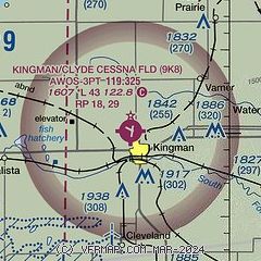
|
| Airport distance calculator |
|---|
|
|
| Sunrise and sunset |
|---|
|
Times for 28-Apr-2026
| | Local
(UTC-5) | | Zulu
(UTC) |
|---|
| Morning civil twilight | | 06:13 | | 11:13 |
| Sunrise | | 06:41 | | 11:41 |
| Sunset | | 20:19 | | 01:19 |
| Evening civil twilight | | 20:47 | | 01:47 |
|
| Current date and time |
|---|
| Zulu (UTC) | 29-Apr-2026 00:20:26 |
|---|
| Local (UTC-5) | 28-Apr-2026 19:20:26 |
|---|
|
| METAR |
|---|
KHUT
27nm NE | 282352Z 02008G18KT 10SM SCT030 14/06 A3001 RMK AO2 PRESRR SLP150 T01390061 10172 20128 53016 $
|
KPTT
30nm W | 282355Z AUTO 36012KT 10SM CLR 16/05 A3001 RMK AO2 T01620048 10185 20128
|
KANY
31nm S | 282355Z AUTO 01013KT 10SM CLR 20/06 A2996 RMK AO2 10213 20142
|
KP28
31nm SW | 282356Z AUTO 35009G19KT 20/06 A2998 RMK AO1 SLP147 T02000056 10228 20156 53016 $
|
KICT
33nm E | 282353Z 01013KT 10SM BKN041 16/07 A2998 RMK AO2 SLP151 T01610072 10194 20133 53015
|
KLYO
41nm N | 282355Z AUTO 36012G16KT 10SM SCT037 13/06 A3002 RMK AO2 T01320056 10159 20119 401810043
|
KEGT
41nm SE | 282355Z AUTO 02012KT 10SM SCT045 18/08 A2997 RMK AO2 T01760079 10205 20143 402250081
|
KIAB
41nm E | 282355Z AUTO 01010KT 10SM OVC036 16/08 A2996 RMK AO2 SLP147 T01600080 10185 20137 53013
|
KBEC
43nm E | 282355Z AUTO 36008KT 10SM SCT035 OVC041 15/07 A2998 RMK AO2 T01510074 10174 20129
|
KAAO
43nm E | 282354Z AUTO 01012KT 10SM OVC042 15/07 A2998 RMK AO2 SLP153 T01500072 10178 20128 53014
|
|
| TAF |
|---|
KHUT
27nm NE | 281742Z 2818/2918 04010KT P6SM BKN020 FM282000 03009KT P6SM BKN035 FM282200 01010KT P6SM SCT070 FM291200 34005KT P6SM BKN180
|
KICT
33nm E | 281742Z 2818/2918 01010G18KT P6SM SCT020 BKN050 FM282200 01010KT P6SM SCT040 FM291200 35007KT P6SM BKN200
|
|
| NOTAMs |
|---|
NOTAMs are issued by the DoD/FAA and will open in a separate window not controlled by AirNav.
|
|

