FAA INFORMATION EFFECTIVE 14 MAY 2026
Location
| FAA Identifier: | ABQ |
| Lat/Long: | 35-02-20.1536N 106-36-29.7438W
35-02.335893N 106-36.495730W
35.0389316,-106.6082622
(estimated) |
| Elevation: | 5354.9 ft. / 1632.2 m (surveyed) |
| Variation: | 11E (1995) |
| From city: | 3 miles SE of ALBUQUERQUE, NM |
| Time zone: | UTC -6 (UTC -7 during Standard Time) |
| Zip code: | 87106 |
Airport Operations
| Airport use: | Open to the public |
| Activation date: | 11/1938 |
| Control tower: | yes |
| ARTCC: | ALBUQUERQUE CENTER |
| FSS: | ALBUQUERQUE FLIGHT SERVICE STATION |
| NOTAMs facility: | ABQ (NOTAM-D service available) |
| Attendance: | CONTINUOUS |
| Wind indicator: | lighted |
| Segmented circle: | no |
| Lights: | SS-SR |
| Beacon: | white-green (lighted land airport)
Operates sunset to sunrise. |
| Fire and rescue: | ARFF index C |
| International operations: | customs landing rights airport |
Airport Communications
| UNICOM: | 122.95 |
| WX ASOS: | PHONE 505-373-2492 |
| ALBUQUERQUE GROUND: | 121.9 348.6 |
| ALBUQUERQUE TOWER: | 120.3 351.9 123.775 |
| ALBUQUERQUE APPROACH: | 123.9 ;SOUTH OF V12 127.4 ;ON OR NORTH OF V12 253.5 ;ON OR NORTH OF V12 354.1 ;SOUTH OF V12 126.3 |
| ALBUQUERQUE DEPARTURE: | 123.9 ;SOUTH OF V12 127.4 ;ON OR NORTH OF V12 253.5 ;ON OR NORTH OF V12 354.1 ;SOUTH OF V12 |
| CLEARANCE DELIVERY: | 119.2 259.3 |
| CLASS C: | 123.9 ;SOUTH OF V12 127.4 ;ON OR NORTH OF V12 253.5 ;ON OR NORTH OF V12 354.1 ;SOUTH OF V12 |
| CURLY STAR: | 127.4 253.5 |
| D-ATIS: | 118.0 257.7 |
| EMERG: | 121.5 243.0 |
| IC: | 123.9 ;SOUTH OF V12 354.1 ;SOUTH OF V12 |
| LAVAN STAR: | 123.9 354.1 |
| MIERA STAR: | 123.9 354.1 |
| PMSV METRO: | 342.3 |
| PTD: | 372.2 |
| WX AWOS-3PT at AEG (11 nm NW): | PHONE 505-842-2009 |
- OTHER OPNS CALLS ARE KING/JOLLY/SAVE AND TAM OPERATED BY ANG AND NAVY.
- SAID IN USE. OPERATE TRANSPONDERS WITH ALTITUDE REPORTING MODE AND ADS-B (IF EQUIPPED) ENABLED ON ALL AIRPORT SURFACES.
- PTD OTS.
Nearby radio navigation aids
| VOR radial/distance | | VOR name | | Freq | | Var |
|---|
| ABQr079/10.2 | | ALBUQUERQUE VORTAC | | 113.20 | | 13E |
| OTOr254/(33.1) | | OTTO VOR | | 114.45 | | 13E |
| NDB name | | Hdg/Dist | | Freq | | Var | | ID |
|---|
| DUDLE | | 143/11.9 | | 351 | | 11E | | AE | .- . |
Airport Services
| Fuel available: | 100LL JET-A JET-A1 JET-A1+ |
| Parking: | hangars and tiedowns |
| Airframe service: | MAJOR |
| Powerplant service: | MAJOR |
| Bottled oxygen: | HIGH/LOW |
| Bulk oxygen: | HIGH/LOW |
Runway Information
Runway 8/26
| Dimensions: | 13793 x 150 ft. / 4204 x 46 m |
| Surface: | concrete/grooved, in good condition |
| Weight bearing capacity: | | Single wheel: | 100.0 | | Double wheel: | 210.0 | | Double tandem: | 360.0 | | Dual double tandem: | 720.0 |
|
| Runway edge lights: | high intensity |
| RUNWAY 8 | | RUNWAY 26 |
| Latitude: | 35-02.661160N | | 35-02.643772N |
| Longitude: | 106-37.295310W | | 106-34.531440W |
| Elevation: | 5311.9 ft. | | 5354.9 ft. |
| Traffic pattern: | right | | left |
| Runway heading: | 079 magnetic, 090 true | | 259 magnetic, 270 true |
| Displaced threshold: | 1000 ft. | | no |
| Declared distances: | TORA:13793 TODA:13793 ASDA:13793 LDA:12793 | | TORA:13793 TODA:13793 ASDA:13793 LDA:13793 |
| Markings: | precision, in good condition | | precision, in good condition |
| Visual slope indicator: | 6-box VASI on left (2.95 degrees glide path) | | 4-light PAPI on left (3.00 degrees glide path)
PAPI DOES NOT PRVD OBST CLNC BYD 3.5 NM FM THR; UNUSBL BYD 3.5 NM. |
| RVR equipment: | touchdown | | rollout |
| Approach lights: | MALSR: 1,400 foot medium intensity approach lighting system with runway alignment indicator lights | | |
| Runway end identifier lights: | | | yes |
| Centerline lights: | yes | | yes |
| Touchdown point: | yes, lighted | | yes, no lights |
| Instrument approach: | ILS/DME | | |
Runway 3/21
| Dimensions: | 10000 x 150 ft. / 3048 x 46 m |
| Surface: | concrete/grooved, in good condition |
| Weight bearing capacity: | | Single wheel: | 100.0 | | Double wheel: | 210.0 | | Double tandem: | 360.0 | | Dual double tandem: | 720.0 |
|
| Runway edge lights: | high intensity |
| RUNWAY 3 | | RUNWAY 21 |
| Latitude: | 35-01.334890N | | 35-02.504457N |
| Longitude: | 106-37.836092W | | 106-36.424388W |
| Elevation: | 5305.1 ft. | | 5316.1 ft. |
| Traffic pattern: | right | | left |
| Runway heading: | 034 magnetic, 045 true | | 214 magnetic, 225 true |
| Declared distances: | TORA:10000 TODA:10000 ASDA:9754 LDA:9754 | | TORA:10000 TODA:10000 ASDA:10000 LDA:10000 |
| Markings: | precision, in good condition | | precision, in good condition |
| Visual slope indicator: | 4-light PAPI on left (3.00 degrees glide path) | | 4-light PAPI on left (3.00 degrees glide path) |
| RVR equipment: | touchdown, rollout | | touchdown, rollout |
| Approach lights: | MALSR: 1,400 foot medium intensity approach lighting system with runway alignment indicator lights | | |
| Runway end identifier lights: | no | | yes |
| Centerline lights: | yes | | yes |
| Touchdown point: | yes, lighted | | yes, no lights |
| Instrument approach: | ILS | | |
Runway 12/30
| Dimensions: | 6000 x 150 ft. / 1829 x 46 m |
| Surface: | concrete/grooved, in good condition |
| Weight bearing capacity: | | Single wheel: | 65.0 | | Double wheel: | 120.0 | | Double tandem: | 155.0 |
|
| Runway edge lights: | medium intensity |
| RUNWAY 12 | | RUNWAY 30 |
| Latitude: | 35-02.612007N | | 35-01.991678N |
| Longitude: | 106-37.245090W | | 106-36.308812W |
| Elevation: | 5312.4 ft. | | 5313.6 ft. |
| Traffic pattern: | right | | left |
| Runway heading: | 118 magnetic, 129 true | | 298 magnetic, 309 true |
| Declared distances: | TORA:6000 TODA:6000 ASDA:6000 LDA:6000 | | TORA:6000 TODA:6000 ASDA:6000 LDA:6000 |
| Markings: | basic, in good condition | | basic, in good condition |
| Visual slope indicator: | | | 4-light PAPI on left (3.00 degrees glide path) |
| RVR equipment: | rollout | | touchdown |
| Runway end identifier lights: | | | yes |
| Touchdown point: | yes, no lights | | yes, no lights |
Airport Ownership and Management from official FAA records
| Ownership: | Publicly-owned |
| Owner: | CITY OF ALBUQUERQUE
PO BOX 1293
ALBUQUERQUE, NM 87103
Phone 505-768-3000 |
| Manager: | MANNY MANRIQUEZ
PO BOX 9948
ALBUQUERQUE, NM 87119
Phone 505-244-7700
RICHARD MCCURLEY |
Additional Remarks
| A39-12/30 | PCR VALUE: 460/R/D/W/T |
| A39-03/21 | PCR VALUE: 800/R/D/W/T |
| A39-08/26 | PCR VALUE: 700/R/B/W/T |
| A30A-08 | RWY 08 & 12 APCH END DECOUPLED; COMMON HOLD SHORT LINE SHARED. |
| A30A-03 | DEP RSTRD; PPR - ATCT. |
| A30A-30 | LNDG: LAST AVBL EXIT TXY E; EXIT E1 NOT PSBL. |
| A30A-12 | TKOF VIA TXY E; FULL LEN AVBL VIA BACK TAX. RWY 08 & 12 APCH ENDS DECOUPLED; COMMON HOLD SHORT LINE SHARED. |
| A57-08 | APCH RATIO 50:1 TO DTHR. |
| - | ACR GND HANDLING NA 0100-0430. |
| - | BIRD HAZ OCT-DEC & MAR-MAY; STUDENT HEL TFC. |
| - | TWY H MIL USE ONLY. |
| - | FIGHTER ACFT DEP S ONLY. |
| - | TWY E5 CLSD. |
| - | SVC: MIL FUEL A++; A++ 100. |
| - | MIL WX SVC AVBL 1300-0600Z++ MON-FRI; CLSD WKEND, HOL & DOWN DAYS. AFT HR MSN WX SUPPORT BRIEFINGS - 25 OWS/DAVIS-MONTHAN AFB D228-6604/C520-228-6604. NWS KABQ FCST - D246-9707/C505-846-9707. FAA OBS H24 - C505-246-4200. |
| - | MISC: FOR TMPRY DUTY OF 2 OR MORE DAYS, OR MSN REQ SPECIAL HANDLING, CTC 377ABW/IG AT DSN 253-4376/1304 OR C505-853-4376/1304 NLT 14 DAYS PRIOR TO ANTICIPATED ARR DATE. |
| - | AF - MIL WX SVC AVBL 1300-0600Z++ MON-FRI. |
| - | AF - KIRTLAND AFB AFLD MGMNT OPR 1400-0300Z++ MON-FRI. |
| - | CTL FIRING AREA S. |
| - | ARFF PRVDD BY USAF. |
Instrument Procedures
NOTE: All procedures below are presented as PDF files. If you need a reader for these files, you should download the free Adobe Reader.NOT FOR NAVIGATION. Please procure official charts for flight.
FAA instrument procedures published for use from 14 May 2026 at 0901Z to 11 June 2026 at 0900Z.
STARs - Standard Terminal Arrivals |
|---|
| BRRTO ONE (RNAV) | |
2 pages:
[1] [2] (407KB) |
| COLTR FOUR (RNAV) | |
download (311KB) |
| CURLY THREE | |
download (138KB) |
| CURLY THREE | |
download (138KB) |
| FRIHO FOUR | |
download (134KB) |
| LAVAN THREE | |
download (154KB) |
| LOWBO THREE (RNAV) | |
2 pages:
[1] [2] (433KB) |
| LZZRD FOUR (RNAV) | |
2 pages:
[1] [2] (365KB) |
| MIERA TWO | |
download (201KB) |
| SNDIA FOUR (RNAV) | |
download (317KB) |
IAPs - Instrument Approach Procedures |
|---|
| HI-ILS OR LOC RWY 08 | |
download (283KB) |
| ILS OR LOC RWY 03 | |
download (301KB) |
| ILS OR LOC RWY 08 | |
download (275KB) |
| RNAV (RNP) Y RWY 21 | |
download (229KB) |
| RNAV (RNP) Y RWY 26 | |
download (235KB) |
| RNAV (RNP) Z RWY 03 | |
download (254KB) |
| RNAV (RNP) Z RWY 08 | |
download (261KB) |
| RNAV (RNP) Z RWY 21 | |
download (274KB) |
| RNAV (RNP) Z RWY 26 | |
download (262KB) |
| RNAV (GPS) Y RWY 03 | |
download (250KB) |
| RNAV (GPS) Y RWY 08 | |
download (243KB) |
| VOR RWY 08 | |
download (293KB) |
| HI-TACAN RWY 08 | |
download (216KB) |
| Radar Approach Procedures available | |
download |
| NOTE: Special Alternate Minimums apply | |
download (145KB) |
Departure Procedures |
|---|
| ADYOS THREE (RNAV) | |
download (253KB) |
| ALBUQUERQUE THREE | |
download (246KB) |
| ATOMK THREE (RNAV) | |
download (227KB) |
| BOSQE THREE (RNAV) | |
download (286KB) |
| DOOKK THREE (RNAV) | |
download (295KB) |
| FYSTA THREE (RNAV) | |
download (246KB) |
| GRZZZ FOUR (RNAV) | |
download (228KB) |
| JEMEZ THREE (RNAV) | |
download (196KB) |
| LARGO THREE | |
download (271KB) |
| MNZNO THREE (RNAV) | |
2 pages:
[1] [2] (414KB) |
| RDRNR THREE (RNAV) | |
download (230KB) |
| NOTE: Special Take-Off Minimums/Departure Procedures apply | |
download |
Other nearby airports with instrument procedures:
KAEG - Double Eagle II Airport (11 nm NW)
KBRG - Belen Regional Airport (26 nm SW)
0E0 - Moriarty Municipal Airport (30 nm E)
KSAF - Santa Fe Regional Airport (43 nm NE)
KLAM - Los Alamos Airport (53 nm N)
|
|

Road maps at:
MapQuest
Bing
Google
| Aerial photo |
|---|
WARNING: Photo may not be current or correct
 Photo by Imagewerx.us Aerial Photography
Photo taken 23-Feb-2017
looking East. Taken from 10,500.
Photo by Imagewerx.us Aerial Photography
Photo taken 23-Feb-2017
looking East. Taken from 10,500.
Do you have a better or more recent aerial photo of Albuquerque International Sunport Airport that you would like to share? If so, please send us your photo.
|
| Sectional chart |
|---|
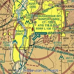
|
CAUTION: Diagram may not be current
 Download PDF
of official airport diagram from the FAA
| Airport distance calculator |
|---|
|
|
| Sunrise and sunset |
|---|
|
Times for 23-May-2026
| | Local
(UTC-6) | | Zulu
(UTC) |
|---|
| Morning civil twilight | | 05:30 | | 11:30 |
| Sunrise | | 05:58 | | 11:58 |
| Sunset | | 20:08 | | 02:08 |
| Evening civil twilight | | 20:37 | | 02:37 |
|
| Current date and time |
|---|
| Zulu (UTC) | 24-May-2026 00:42:06 |
|---|
| Local (UTC-6) | 23-May-2026 18:42:06 |
|---|
|
| METAR |
|---|
| KABQ | 232352Z 29012KT 10SM SCT130 SCT250 28/M04 A3002 RMK AO2 SLP086 VIRGA SE T02831044 10283 20233 58010
|
KAEG
11nm NW | 232250Z 29006KT 10SM CLR 27/M06 A3007
|
|
| TAF |
|---|
| KABQ | 231721Z 2318/2418 VRB05KT P6SM FEW070 FM232100 25008KT P6SM SCT120 FM240300 10007KT P6SM SCT150 FM240800 09011G18KT P6SM BKN150 FM241300 12006KT P6SM SCT150
|
KAEG
11nm NW | 231945Z 2320/2418 18007KT P6SM SCT110 PROB30 2320/2322 VRB15G30KT -SHRA BKN090 FM240300 VRB05KT P6SM BKN150
|
|
| NOTAMs |
|---|
NOTAMs are issued by the DoD/FAA and will open in a separate window not controlled by AirNav.
|
|


