FAA INFORMATION EFFECTIVE 14 MAY 2026
Location
| FAA Identifier: | AIG |
| Lat/Long: | 45-09-14.2189N 089-06-38.2203W
45-09.236982N 089-06.637005W
45.1539497,-89.1106167
(estimated) |
| Elevation: | 1523 ft. / 464.2 m (surveyed) |
| Variation: | 02W (1995) |
| From city: | 2 miles NE of ANTIGO, WI |
| Time zone: | UTC -5 (UTC -6 during Standard Time) |
| Zip code: | 54409 |
Airport Operations
| Airport use: | Open to the public |
| Activation date: | 10/1944 |
| Control tower: | no |
| ARTCC: | MINNEAPOLIS CENTER |
| FSS: | GREEN BAY FLIGHT SERVICE STATION |
| NOTAMs facility: | AIG (NOTAM-D service available) |
| Attendance: | MON-SAT 0800-1700, ALL SUN 0900-1600 |
| Wind indicator: | lighted |
| Segmented circle: | no |
| Lights: | MIRL RWY 17/35 & 09/27 PRESET TO LOW SS-SR; TO INCR INTST AND ACTVT REIL RWY 17 & 35; PAPI RWY 09, 17, 27 & 35 - CTAF. |
| Beacon: | white-green (lighted land airport)
Operates sunset to sunrise. |
Airport Communications
| CTAF/UNICOM: | 122.8 |
| WX AWOS-3: | 119.075 (715-627-2869) |
- APCH/DEP SVC PRVDD BY MINNEAPOLIS ARTCC ON FREQS 124.4/317.7 (MOSINEE RCAG).
Nearby radio navigation aids
| VOR radial/distance | | VOR name | | Freq | | Var |
|---|
| RHIr151/32.3 | | RHINELANDER VOR/DME | | 115.05 | | 02E |
Airport Services
| Fuel available: | 100LL JET-A |
| Parking: | hangars and tiedowns |
| Airframe service: | MINOR |
| Powerplant service: | MINOR |
| Bottled oxygen: | NONE |
| Bulk oxygen: | NONE |
Runway Information
Runway 17/35
| Dimensions: | 4010 x 75 ft. / 1222 x 23 m |
| Surface: | asphalt/aggregate friction seal coat, in fair condition |
| Weight bearing capacity: | |
| Runway edge lights: | medium intensity |
| RUNWAY 17 | | RUNWAY 35 |
| Latitude: | 45-09.548467N | | 45-08.913880N |
| Longitude: | 089-06.616692W | | 089-06.361308W |
| Elevation: | 1520.5 ft. | | 1517.9 ft. |
| Traffic pattern: | left | | left |
| Runway heading: | 166 magnetic, 164 true | | 346 magnetic, 344 true |
| Markings: | nonprecision, in fair condition | | nonprecision, in fair condition |
| Visual slope indicator: | 2-light PAPI on left (3.00 degrees glide path) | | 2-light PAPI on left (3.00 degrees glide path)
PAPI UNUSBL BYD 7 DEGS LEFT OF CNTRLN. |
| Runway end identifier lights: | yes | | yes |
| Touchdown point: | yes, no lights | | yes, no lights |
Runway 9/27
| Dimensions: | 3400 x 75 ft. / 1036 x 23 m |
| Surface: | asphalt/aggregate friction seal coat, in excellent condition |
| Weight bearing capacity: | |
| Runway edge lights: | medium intensity |
| RUNWAY 9 | | RUNWAY 27 |
| Latitude: | 45-09.210220N | | 45-09.277447N |
| Longitude: | 089-07.203987W | | 089-06.419143W |
| Elevation: | 1516.0 ft. | | 1522.8 ft. |
| Traffic pattern: | left | | left |
| Runway heading: | 085 magnetic, 083 true | | 265 magnetic, 263 true |
| Markings: | nonprecision, in good condition | | nonprecision, in good condition |
| Visual slope indicator: | 2-light PAPI on left (3.00 degrees glide path) | | 2-light PAPI on left (3.00 degrees glide path) |
| Touchdown point: | yes, no lights | | yes, no lights |
Airport Ownership and Management from official FAA records
| Ownership: | Publicly-owned |
| Owner: | LANGLADE COUNTY
N3689 N LANGLADE RD
ANTIGO, WI 54409
Phone (715) 623-3539 |
| Manager: | DONALD BINTZ
N3689 N LANGLADE RD
ANTIGO, WI 54409
Phone 702-324-9966 |
Additional Remarks
| - | FOR CD CTC MINNEAPOLIS ARTCC AT 651-463-5588. |
Instrument Procedures
NOTE: All procedures below are presented as PDF files. If you need a reader for these files, you should download the free Adobe Reader.NOT FOR NAVIGATION. Please procure official charts for flight.
FAA instrument procedures published for use from 14 May 2026 at 0901Z to 11 June 2026 at 0900Z.
IAPs - Instrument Approach Procedures |
|---|
| RNAV (GPS) RWY 09 | |
download (205KB) |
| RNAV (GPS) RWY 17 | |
download (232KB) |
| RNAV (GPS) RWY 27 | |
download (198KB) |
| RNAV (GPS) RWY 35 | |
download (234KB) |
| NOTE: Special Alternate Minimums apply | |
download (163KB) |
| NOTE: Special Take-Off Minimums/Departure Procedures apply | |
download (203KB) |
Other nearby airports with instrument procedures:
Y55 - Crandon/Steve Conway Municipal Airport (23 nm N)
KRRL - Merrill Municipal Airport (26 nm W)
KAUW - Wausau Downtown Airport (26 nm SW)
KEZS - Shawano Municipal Airport (32 nm SE)
KRHI - Rhinelander/Oneida County Airport (32 nm NW)
|
|

Road maps at:
MapQuest
Bing
Google
| Aerial photo |
|---|
WARNING: Photo may not be current or correct
 Photo by Laurie Probst
Photo taken 22-Sep-2007
Photo by Laurie Probst
Photo taken 22-Sep-2007
Do you have a better or more recent aerial photo of Langlade County Airport that you would like to share? If so, please send us your photo.
|
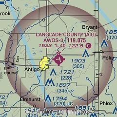
| Sectional chart |
|---|
|
| Airport distance calculator |
|---|
|
|
| Sunrise and sunset |
|---|
|
Times for 20-May-2026
| | Local
(UTC-5) | | Zulu
(UTC) |
|---|
| Morning civil twilight | | 04:48 | | 09:48 |
| Sunrise | | 05:23 | | 10:23 |
| Sunset | | 20:23 | | 01:23 |
| Evening civil twilight | | 20:58 | | 01:58 |
|
| Current date and time |
|---|
| Zulu (UTC) | 20-May-2026 23:29:53 |
|---|
| Local (UTC-5) | 20-May-2026 18:29:53 |
|---|
|
| METAR |
|---|
KAIG
8nm S | 202315Z AUTO 00000KT 10SM CLR 13/01 A3027 RMK AO2 T01260005
|
|
| TAF |
|---|
KAUW
25nm SW | 201730Z 2018/2118 35003KT P6SM BKN040 FM210100 10003KT P6SM SCT090 FM210900 10004KT P6SM SCT120 FM211300 11005KT P6SM BKN120
|
|
| NOTAMs |
|---|
NOTAMs are issued by the DoD/FAA and will open in a separate window not controlled by AirNav.
|
|

