FAA INFORMATION EFFECTIVE 19 MARCH 2026
Location
| FAA Identifier: | AJZ |
| Lat/Long: | 38-47-08.1720N 108-03-43.2490W
38-47.136200N 108-03.720817W
38.7856033,-108.0620136
(estimated) |
| Elevation: | 5193.1 ft. / 1582.9 m (surveyed) |
| Variation: | 10E (2020) |
| From city: | 3 miles N of DELTA, CO |
| Time zone: | UTC -6 (UTC -7 during Standard Time) |
| Zip code: | 81416 |
Airport Operations
| Airport use: | Open to the public |
| Activation date: | 03/1962 |
| Control tower: | no |
| ARTCC: | DENVER CENTER |
| FSS: | DENVER FLIGHT SERVICE STATION |
| NOTAMs facility: | DEN (NOTAM-D service available) |
| Attendance: | MON-FRI 0800-1700
AFT HRS EMERG FONE, SHERIFF DEPT 970-874-2000/AFT HRS SVC 970-209-0883. |
| Pattern altitude: | 6200.1 ft. MSL |
| Wind indicator: | lighted |
| Segmented circle: | yes |
| Lights: | ACTVT REIL RWY 03 & 21; MIRL RWY 03/21 - CTAF. PAPI RWY 03 & 21 ON CONSLY. |
| Beacon: | white-green (lighted land airport)
Operates sunset to sunrise. |
Airport Communications
| CTAF/UNICOM: | 122.8 |
| WX AWOS-3: | 134.0 (970-874-3251) |
| WX ASOS at MTJ (18 nm SE): | 135.225 (970-249-1534) |
- APCH/DEP CTLSVC PRVDD BY DENVER ARTCC (ZDV) ON 127.1(GRAND MESA/A/ RCAG & MONTROSE RCAG) 343.65 (MESA/A RCAG).
Nearby radio navigation aids
| VOR radial/distance | | VOR name | | Freq | | Var |
|---|
| MTJr324/18.4 | | MONTROSE VOR/DME | | 117.10 | | 12E |
| JNCr101/37.9 | | GRAND JUNCTION VOR/DME | | 112.40 | | 15E |
Airport Services
| Fuel available: | 100LL JET-A |
| Parking: | hangars and tiedowns |
| Airframe service: | MAJOR |
| Powerplant service: | MINOR |
| Bottled oxygen: | HIGH |
| Bulk oxygen: | NONE |
Runway Information
Runway 3/21
| Dimensions: | 5598 x 75 ft. / 1706 x 23 m |
| Surface: | asphalt, in good condition |
| Weight bearing capacity: | | Single wheel: | 30.0 | | Double wheel: | 30.0 |
|
| Runway edge lights: | medium intensity |
| RUNWAY 3 | | RUNWAY 21 |
| Latitude: | 38-46.840562N | | 38-47.528962N |
| Longitude: | 108-04.209177W | | 108-03.425662W |
| Elevation: | 5111.1 ft. | | 5193.1 ft. |
| Traffic pattern: | right | | left |
| Runway heading: | 032 magnetic, 042 true | | 212 magnetic, 222 true |
| Markings: | nonprecision, in good condition | | nonprecision, in good condition |
| Visual slope indicator: | 2-light PAPI on left (3.00 degrees glide path) | | 2-light PAPI on left (3.00 degrees glide path) |
| Runway end identifier lights: | yes | | yes |
| Touchdown point: | yes, no lights | | yes, no lights |
Runway 14/32
| Dimensions: | 2494 x 60 ft. / 760 x 18 m |
| Surface: | dirt, in good condition |
| RUNWAY 14 | | RUNWAY 32 |
| Latitude: | 38-47.203867N | | 38-46.850583N |
| Longitude: | 108-03.638000W | | 108-03.370000W |
| Elevation: | 5151.6 ft. | | 5116.3 ft. |
| Traffic pattern: | left | | left |
| Runway heading: | 139 magnetic, 149 true | | 319 magnetic, 329 true |
| Touchdown point: | yes, no lights | | yes, no lights |
Airport Ownership and Management from official FAA records
| Ownership: | Publicly-owned |
| Owner: | COUNTY OF DELTA
DELTA COUNTY
DELTA, CO 81416
Phone (970) 874-5181 |
| Manager: | MARK HUSMANN
870 - 1575 ROAD
DELTA, CO 81416
Phone 970-874-5181 |
Additional Remarks
| A56-03 | 4 FT FENCE 580 FT FM THLD ON EXTDD CNTRLN. |
| - | ANTELOPE ON AND INVOF ARPT. |
| - | RY 21 HAS TURN AROUND TAXI HAS BLUE/WHITE REFLECTORS. |
| - | RY 03/21 SLOPES UP TO THE NE. |
| - | RY 03/21 HAS 4 FT BUSHES 15-20 FT FROM RY EDGE ON BOTH SIDES IN VARIOUS PLACES. |
| - | 24 HOUR SELF SERVE FUEL AVBL. |
| - | RY 3 HAS +4 FT FENCE 580 FT FM THLD OB. |
| - | POWER LINES 2640' NW RY 03/21, +52 FT AGL. |
| - | FOR CD CTC DENVER ARTCC AT 303-651-4257. |
Instrument Procedures
NOTE: All procedures below are presented as PDF files. If you need a reader for these files, you should download the free Adobe Reader.NOT FOR NAVIGATION. Please procure official charts for flight.
FAA instrument procedures published for use from 19 March 2026 at 0901Z to 16 April 2026 at 0900Z.
IAPs - Instrument Approach Procedures |
|---|
| RNAV (GPS) RWY 03 | |
download (386KB) |
| NOTE: Special Alternate Minimums apply | |
download (149KB) |
| NOTE: Special Take-Off Minimums/Departure Procedures apply | |
download (299KB) |
Other nearby airports with instrument procedures:
KMTJ - Montrose Regional Airport (18 nm SE)
KGJT - Grand Junction Regional Airport (30 nm NW)
KAIB - Hopkins Field Airport (40 nm SW)
KRIL - Rifle Garfield County Airport (47 nm N)
KTEX - Telluride Regional Airport (50 nm S)
|
|

Road maps at:
MapQuest
Bing
Google
| Aerial photo |
|---|
WARNING: Photo may not be current or correct
 Photo taken 30-Aug-2014
looking northeast.
Photo taken 30-Aug-2014
looking northeast.
Do you have a better or more recent aerial photo of Blake Field Airport that you would like to share? If so, please send us your photo.
|
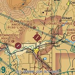
| Sectional chart |
|---|
|
| Airport distance calculator |
|---|
|
|
| Sunrise and sunset |
|---|
|
Times for 23-Mar-2026
| | Local
(UTC-6) | | Zulu
(UTC) |
|---|
| Morning civil twilight | | 06:45 | | 12:45 |
| Sunrise | | 07:12 | | 13:12 |
| Sunset | | 19:26 | | 01:26 |
| Evening civil twilight | | 19:52 | | 01:52 |
|
| Current date and time |
|---|
| Zulu (UTC) | 23-Mar-2026 21:15:12 |
|---|
| Local (UTC-6) | 23-Mar-2026 15:15:12 |
|---|
|
| METAR |
|---|
| KAJZ | 232055Z AUTO 00000KT 10SM CLR 25/M05 A3003 RMK AO2 T02511052
|
KMTJ
19nm SE | 232053Z AUTO 23011KT 10SM CLR 24/M06 A3007 RMK AO2 SLP111 T02441056 58025
|
|
| TAF |
|---|
KMTJ
19nm SE | 231739Z 2318/2418 29008KT P6SM FEW130 BKN250 FM232000 30010G20KT P6SM SCT130 BKN250 FM240000 30011KT P6SM SCT130 BKN250 FM240400 14008KT P6SM SCT130 SCT250 FM241300 VRB04KT P6SM FEW250
|
|
| NOTAMs |
|---|
NOTAMs are issued by the DoD/FAA and will open in a separate window not controlled by AirNav.
|
|


