FAA INFORMATION EFFECTIVE 18 APRIL 2024
Location
| FAA Identifier: | AXV |
| Lat/Long: | 40-29-36.7730N 084-17-53.0680W
40-29.612883N 084-17.884467W
40.4935481,-84.2980744
(estimated) |
| Elevation: | 912.3 ft. / 278.1 m (surveyed) |
| Variation: | 04W (1985) |
| From city: | 8 miles SW of WAPAKONETA, OH |
| Time zone: | UTC -4 (UTC -5 during Standard Time) |
| Zip code: | 45871 |
Airport Operations
| Airport use: | Open to the public |
| Activation date: | 05/1956 |
| Control tower: | no |
| ARTCC: | INDIANAPOLIS CENTER |
| FSS: | DAYTON FLIGHT SERVICE STATION |
| NOTAMs facility: | DAY (NOTAM-D service available) |
| Attendance: | MON-FRI 0700-1700, ALL SAT-SUN ON CALL
FOR SVC & FUEL CALL AMGR. |
| Pattern altitude: | 1902.3 ft. MSL |
| Wind indicator: | lighted |
| Segmented circle: | no |
| Lights: | ACTVT REIL RWY 08 & 26; MIRL RWY 08/26 - 122.7. |
| Beacon: | white-green (lighted land airport)
Operates sunset to sunrise. |
Airport Communications
| CTAF/UNICOM: | 122.8 |
| WX AWOS-3PT: | 128.325 (419-753-2821) |
| COLUMBUS APPROACH: | 134.45 |
| COLUMBUS DEPARTURE: | 134.45 |
| WX AWOS-3 at SCA (17 nm SE): | 120.425 (937-492-3683) |
| WX ASOS at AOH (18 nm NE): | 128.725 (419-224-6098) |
Nearby radio navigation aids
| VOR radial/distance | | VOR name | | Freq | | Var |
|---|
| RODr322/17.0 | | ROSEWOOD VORTAC | | 117.50 | | 05W |
| DQNr010/29.0 | | DAYTON VOR/DME | | 114.50 | | 01W |
| FBCr224/37.1 | | FLAG CITY VORTAC | | 108.20 | | 02W |
Airport Services
| Fuel available: | 100LL JET-A1+
100LL:100LL & JET A1+ AVBL H24 SELF SVC VIA CREDIT CARD. |
| Parking: | tiedowns |
| Airframe service: | MAJOR |
| Powerplant service: | MAJOR |
| Bottled oxygen: | HIGH |
| Bulk oxygen: | NONE |
Runway Information
Runway 8/26
| Dimensions: | 5500 x 100 ft. / 1676 x 30 m |
| Surface: | asphalt/grooved, in good condition |
| Runway edge lights: | medium intensity |
| RUNWAY 8 | | RUNWAY 26 |
| Latitude: | 40-29.507773N | | 40-29.717953N |
| Longitude: | 084-18.461433W | | 084-17.307480W |
| Elevation: | 907.7 ft. | | 908.0 ft. |
| Traffic pattern: | left | | left |
| Runway heading: | 081 magnetic, 077 true | | 261 magnetic, 257 true |
| Displaced threshold: | 698 ft. | | 237 ft. |
| Markings: | nonprecision, in good condition | | nonprecision, in good condition |
| Visual slope indicator: | 4-light PAPI on left (4.00 degrees glide path) | | 4-light PAPI on left (3.00 degrees glide path) |
| Runway end identifier lights: | yes | | yes |
| Touchdown point: | yes, no lights | | yes, no lights |
| Instrument approach: | | | LOC/DME |
| Obstructions: | 89 ft. trees, 479 ft. from runway, 248 ft. left of centerline, 3:1 slope to clear
3 FT CROPS, 0-70 FT DIST, 200 FT R. | | 15 ft. road, 330 ft. from runway, 275 ft. right of centerline, 8:1 slope to clear
8 FT TRRN, 0-40 FT DIST, 190 FT L; 8 FT FENCE, 65-200 FT DIST, 220-230 FT L. |
Airport Ownership and Management from official FAA records
| Ownership: | Publicly-owned |
| Owner: | AUGLAIZE CO ARPT AUTH
PO BOX 400
NEW KNOXVILLE, OH 45871-0400
Phone 419-753-2810 |
| Manager: | TED BERGSTROM
PO BOX 400
NEW KNOXVILLE, OH 45871-0400
Phone 419-753-2810 |
Airport Operational Statistics
| Aircraft based on the field: | | 33 | | Single engine airplanes: | | 26 | | Multi engine airplanes: | | 2 | | Jet airplanes: | | 5 |
| |  | |
| Aircraft operations: avg 34/day * | | 57% | local general aviation | | 28% | transient general aviation | | 15% | air taxi | | <1% | military | | * for 12-month period ending 14 September 2021 | |
Additional Remarks
| - | FOR CD CTC COLUMBUS APCH AT 614-338-8537. |
| - | WILDLIFE ON & INVOF ARPT. |
Instrument Procedures
NOTE: All procedures below are presented as PDF files. If you need a reader for these files, you should download the free Adobe Reader.NOT FOR NAVIGATION. Please procure official charts for flight.
FAA instrument procedures published for use from 18 April 2024 at 0901Z to 16 May 2024 at 0900Z.
IAPs - Instrument Approach Procedures |
|---|
| RNAV (GPS) RWY 08 | |
download (212KB) |
| RNAV (GPS) RWY 26 | |
download (231KB) |
| VOR-A | |
download (192KB) |
| NOTE: Special Take-Off Minimums/Departure Procedures apply | |
download (164KB) |
Other nearby airports with instrument procedures:
KCQA - Lakefield Airport (12 nm W)
KSCA - Sidney Municipal Airport (17 nm SE)
KAOH - Lima Allen County Airport (18 nm NE)
I17 - Piqua Airport/Hartzell Field (20 nm S)
KVES - Darke County Airport (20 nm SW)
|
|

Road maps at:
MapQuest
Bing
Google
| Aerial photo |
|---|
WARNING: Photo may not be current or correct
 Photo taken 24-Jul-2006
from a Cessna 340 at 12000 ft MSL
Photo taken 24-Jul-2006
from a Cessna 340 at 12000 ft MSL
Do you have a better or more recent aerial photo of Neil Armstrong Airport that you would like to share? If so, please send us your photo.
|
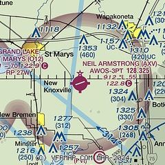
| Sectional chart |
|---|
|
| Airport distance calculator |
|---|
|
|
| Sunrise and sunset |
|---|
|
Times for 19-Apr-2024
| | Local
(UTC-4) | | Zulu
(UTC) |
|---|
| Morning civil twilight | | 06:24 | | 10:24 |
| Sunrise | | 06:52 | | 10:52 |
| Sunset | | 20:20 | | 00:20 |
| Evening civil twilight | | 20:49 | | 00:49 |
|
| Current date and time |
|---|
| Zulu (UTC) | 19-Apr-2024 15:38:37 |
|---|
| Local (UTC-4) | 19-Apr-2024 11:38:37 |
|---|
|
| METAR |
|---|
| KAXV | 191515Z AUTO 33009G15KT 10SM OVC012 10/07 A3005 RMK AO2
|
KAOH
18nm NE | 191453Z AUTO 31013KT 10SM OVC012 10/08 A3004 RMK AO2 SLP171 T01000083 51032
|
|
| TAF |
|---|
KDAY
36nm S | 191419Z 1914/2012 33014KT P6SM OVC012 FM191630 32014KT P6SM SCT025 FM191900 32012KT P6SM SCT200 FM200200 29006KT P6SM BKN200 FM200600 27006KT P6SM BKN120
|
KFFO
42nm S | 191113Z 1911/2017 30015G25KT 9999 OVC012 510101 QNH2991INS WND 270V340 BECMG 1911/1913 31015G25KT 9999 OVC009 510101 QNH2996INS WND 270V350 BECMG 1912/1914 32014KT 9999 OVC015 510101 QNH2998INS TEMPO 1914/1916 32015G25KT WND 270V350 BECMG 1914/1916 32012KT 9999 BKN020 BKN200 QNH3001INS TEMPO 1916/1923 32012G18KT WND 280V350 BECMG 1922/1923 31009KT 9999 SCT120 BKN200 QNH3009INS WND VRB06KT AFT 2003 BECMG 2014/2015 29012G18KT 9999 SCT050 QNH3011INS TX16/1911Z TN06/2011Z
|
KFDY
43nm NE | 191131Z 1912/2012 31014G24KT P6SM OVC010 TEMPO 1912/1914 4SM BR BKN004 FM191600 31015G23KT P6SM BKN025 FM191800 29015G25KT P6SM SKC FM200100 29007KT P6SM BKN250
|
|
| NOTAMs |
|---|
NOTAMs are issued by the DoD/FAA and will open in a separate window not controlled by AirNav.
|
|

