FAA INFORMATION EFFECTIVE 09 JULY 2026
Location
| FAA Identifier: | SCA |
| Lat/Long: | 40-14-28.6000N 084-08-52.3000W
40-14.476667N 084-08.871667W
40.2412778,-84.1478611
(estimated) |
| Elevation: | 1044 ft. / 318.2 m (surveyed) |
| Variation: | 05W (1995) |
| From city: | 3 miles S of SIDNEY, OH |
| Time zone: | UTC -4 (UTC -5 during Standard Time) |
| Zip code: | 45365 |
Airport Operations
| Airport use: | Open to the public |
| Activation date: | 12/1956 |
| Control tower: | no |
| ARTCC: | INDIANAPOLIS CENTER |
| FSS: | DAYTON FLIGHT SERVICE STATION |
| NOTAMs facility: | DAY (NOTAM-D service available) |
| Attendance: | MON-SAT 0800-1800 |
| Pattern altitude: | 1844 ft. MSL |
| Wind indicator: | lighted |
| Segmented circle: | no |
| Lights: | ACTVT REIL RWY 10 & 28; MIRL RWY 10/28 - CTAF. PAPI RWY 10 & 28 OPR CONSLY. |
| Beacon: | white-green (lighted land airport)
Operates sunset to sunrise. |
Airport Communications
| CTAF/UNICOM: | 123.05 |
| WX AWOS-3: | 120.425 (937-492-3683) |
| COLUMBUS APPROACH: | 134.45 |
| COLUMBUS DEPARTURE: | 134.45 |
| WX AWOS-3PT at AXV (17 nm NW): | 128.325 (419-753-2821) |
| WX AWOS-3 at EDJ (17 nm NE): | 118.075 (937-599-4654) |
| WX AWOS-3PT at VES (18 nm W): | 125.9 (937-526-3154) |
| WX AWOS-3 at I74 (19 nm E): | 118.325 (937-484-5863) |
Nearby radio navigation aids
| VOR radial/distance | | VOR name | | Freq | | Var |
|---|
| RODr245/5.5 | | ROSEWOOD VORTAC | | 117.50 | | 05W |
| DQNr041/17.7 | | DAYTON VOR/DME | | 114.50 | | 01W |
Airport Services
| Fuel available: | 100LL JET-A
100LL:100LL & JET A AVBL H24 VIA CREDIT CARD.
A:ANTI-ICING ADDITIVE AVBL AT NOZZLE. |
| Parking: | hangars and tiedowns |
| Airframe service: | MAJOR |
| Powerplant service: | MAJOR |
| Bottled oxygen: | NONE |
| Bulk oxygen: | HIGH |
Runway Information
Runway 10/28
| Dimensions: | 5013 x 75 ft. / 1528 x 23 m |
| Surface: | asphalt, in fair condition |
| Runway edge lights: | medium intensity |
| Runway edge markings: | FADED EXC RWY NR. |
| RUNWAY 10 | | RUNWAY 28 |
| Latitude: | 40-14.562002N | | 40-14.501402N |
| Longitude: | 084-09.268428W | | 084-08.193928W |
| Elevation: | 1039.9 ft. | | 1041.4 ft. |
| Traffic pattern: | left | | left |
| Runway heading: | 099 magnetic, 094 true | | 279 magnetic, 274 true |
| Markings: | nonprecision, in poor condition | | nonprecision, in poor condition |
| Visual slope indicator: | 2-light PAPI on left (3.00 degrees glide path) | | 2-light PAPI on left (3.00 degrees glide path) |
| Runway end identifier lights: | yes | | yes |
| Touchdown point: | yes, no lights | | yes, no lights |
| Obstructions: | 7 ft. crops, 201 ft. from runway, 215 ft. left of centerline
7 FT CROPS, 0-200 FT DIST, 215 FT L. | | 15 ft. crops, 201 ft. from runway, 110 ft. left and right of centerline
15 FT CROPS ON SLP, 0-200 FT DIST, 110 FT L/R. |
Runway 5/23
| Dimensions: | 2981 x 50 ft. / 909 x 15 m |
| Surface: | asphalt, in fair condition |
| RUNWAY 5 | | RUNWAY 23 |
| Latitude: | 40-14.196817N | | 40-14.573717N |
| Longitude: | 084-09.310567W | | 084-08.900017W |
| Elevation: | 1034.8 ft. | | 1040.5 ft. |
| Traffic pattern: | left | | left |
| Runway heading: | 045 magnetic, 040 true | | 225 magnetic, 220 true |
| Markings: | nonprecision, in fair condition | | nonprecision, in fair condition |
| Runway end identifier lights: | no | | no |
| Touchdown point: | yes, no lights | | yes, no lights |
| Obstructions: | none | | 8 ft. crops, 201 ft. from runway, 125 ft. both sides of centerline
8 FT CROPS AT PAVEMENT END. |
Airport Ownership and Management from official FAA records
| Ownership: | Publicly-owned |
| Owner: | CITY OF SIDNEY
201 W POPLAR ST
SIDNEY, OH 45365-2720
Phone 937-498-2335 |
| Manager: | MIKE CHAPPIE
14833 SIDNEY-PLATTSVILLE RD
SIDNEY, OH 45365-8772
Phone 937-492-9794 |
Additional Remarks
| - | FOR CD CTC COLUMBUS APCH AT 614-338-8537. |
Instrument Procedures
NOTE: All procedures below are presented as PDF files. If you need a reader for these files, you should download the free Adobe Reader.NOT FOR NAVIGATION. Please procure official charts for flight.
FAA instrument procedures published for use from 09 July 2026 at 0901Z to 06 August 2026 at 0900Z.
IAPs - Instrument Approach Procedures |
|---|
| RNAV (GPS) RWY 10 | |
download (253KB) |
| RNAV (GPS) RWY 28 | |
download (240KB) |
| VOR-A | |
download (187KB) |
| NOTE: Special Take-Off Minimums/Departure Procedures apply | |
download (187KB) |
Other nearby airports with instrument procedures:
I17 - Piqua Airport/Hartzell Field (9 nm SW)
KAXV - Neil Armstrong Airport (17 nm NW)
KEDJ - Bellefontaine Regional Airport (17 nm NE)
KVES - Darke County Airport (18 nm W)
I74 - Grimes Field Airport (19 nm E)
|
|

Road maps at:
MapQuest
Bing
Google
| Aerial photo |
|---|
WARNING: Photo may not be current or correct
 Taken late September 2008
Do you have a better or more recent aerial photo of Sidney Municipal Airport that you would like to share? If so, please send us your photo.
|
| Sectional chart |
|---|
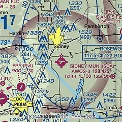
|
| Airport distance calculator |
|---|
|
|
| Sunrise and sunset |
|---|
|
Times for 24-Jul-2026
| | Local
(UTC-4) | | Zulu
(UTC) |
|---|
| Morning civil twilight | | 05:57 | | 09:57 |
| Sunrise | | 06:28 | | 10:28 |
| Sunset | | 20:58 | | 00:58 |
| Evening civil twilight | | 21:29 | | 01:29 |
|
| Current date and time |
|---|
| Zulu (UTC) | 24-Jul-2026 08:48:01 |
|---|
| Local (UTC-4) | 24-Jul-2026 04:48:01 |
|---|
|
| METAR |
|---|
KAXV
17nm NW | 240835Z AUTO 00000KT 10SM BKN050 13/12 A3017 RMK AO2
|
KEDJ
17nm NE | 240835Z AUTO 00000KT 10SM OVC050 15/13 A3018 RMK A01
|
KVES
18nm W | 240835Z AUTO 06002KT 10SM OVC050 14/14 A3017 RMK AO2
|
KI74
19nm E | 240835Z AUTO 00000KT 10SM CLR 11/11 A3016 RMK AO2
|
KDAY
21nm S | 240756Z 04003KT 10SM SCT250 14/12 A3016 RMK AO2 SLP210 T01440117 $
|
KFFO
26nm S | 240755Z AUTO 00000KT 6SM HZ CLR 16/13 A3015 RMK AO2 SLP208 T01620131
|
KAOH
28nm N | 240753Z AUTO 10005KT 10SM BKN055 14/12 A3017 RMK AO2 SLP214 T01390117
|
KSGH
30nm SE | 240756Z AUTO 00000KT 10SM CLR 13/12 A3017 RMK AO2 SLP214 T01280117
|
|
| TAF |
|---|
KDAY
21nm S | 240529Z 2406/2506 05005KT P6SM BKN250 FM241700 01006KT P6SM FEW050 BKN200 FM250000 34004KT P6SM BKN120
|
|
| NOTAMs |
|---|
NOTAMs are issued by the DoD/FAA and will open in a separate window not controlled by AirNav.
|
|


