FAA INFORMATION EFFECTIVE 16 APRIL 2026
Location
| FAA Identifier: | BFF |
| Lat/Long: | 41-52-26.5000N 103-35-44.3000W
41-52.441667N 103-35.738333W
41.8740278,-103.5956389
(estimated) |
| Elevation: | 3967.3 ft. / 1209.2 m (surveyed) |
| Variation: | 10E (2000) |
| From city: | 3 miles E of SCOTTSBLUFF, NE |
| Time zone: | UTC -6 (UTC -7 during Standard Time) |
| Zip code: | 69361 |
Airport Operations
| Airport use: | Open to the public |
| Activation date: | 02/1944 |
| Control tower: | no |
| ARTCC: | DENVER CENTER |
| FSS: | COLUMBUS FLIGHT SERVICE STATION |
| NOTAMs facility: | BFF (NOTAM-D service available) |
| Attendance: | 0600-2100
FOR SVC AFTER HRS CALL 308-635-0162. |
| Wind indicator: | lighted |
| Segmented circle: | no |
| Lights: | ACTVT MIRL RY 05/23; HIRL RY 12/30; MALSR RYS 12 & 30 & VASI RY 05 & PAPI RYS 12 , 23 AND 30 - CTAF. |
| Beacon: | white-green (lighted land airport)
Operates sunset to sunrise. |
| Fire and rescue: | ARFF index A |
| Airline operations: | PPR 24 HRS FOR ACR OPNS WITH MORE THAN 30 PSGR SEATS CALL AMGR 308-635-4941. AIR CARRIER OPS OVER 9 PASSENGER SEATS NOT AUTHORIZED IN EXCESS OF 15 MINUTES BEFORE OR AFTER SCHEDULED ARRIVAL/DEP TIMES EXCEPT WITH PRIOR COORDINATION WITH AIRPORT MGR. ARFF INDEX B EQUIPMENT IS PROVIDED. |
Airport Communications
| CTAF/UNICOM: | 123.0 |
| WX ASOS: | 121.025 (308-281-6014) |
- APCH/DEP CTL SVC PRVDD BY DENVER ARTCC (ZDV) ON FREQS 127.95/338.2 (CRAWFORD RCAG).
Nearby radio navigation aids
| VOR radial/distance | | VOR name | | Freq | | Var |
|---|
| BFFr244/5.2 | | SCOTTSBLUFF VORTAC | | 112.60 | | 13E |
| AIAr242/36.9 | | ALLIANCE VOR/DME | | 111.80 | | 11E |
| NDB name | | Hdg/Dist | | Freq | | Var | | ID |
|---|
| TORRINGTON | | 108/27.4 | | 293 | | 07E | | TOR | - --- .-. |
Airport Services
| Fuel available: | 100LL JET-A |
| Oil available: | PER AMGR USE CTAF WHEN OPERATING ON THE ARPT. |
| Parking: | hangars and tiedowns |
| Airframe service: | MAJOR |
| Powerplant service: | MAJOR |
| Bottled oxygen: | NONE |
| Bulk oxygen: | LOW |
Runway Information
Runway 12/30
| Dimensions: | 8279 x 150 ft. / 2523 x 46 m |
| Surface: | asphalt, in good condition |
| Weight bearing capacity: | | Single wheel: | 109.0 | | Double wheel: | 178.0 | | Double tandem: | 321.0 |
|
| Runway edge lights: | high intensity |
| RUNWAY 12 | | RUNWAY 30 |
| Latitude: | 41-52.937075N | | 41-51.963392N |
| Longitude: | 103-36.297098W | | 103-35.021105W |
| Elevation: | 3961.8 ft. | | 3944.1 ft. |
| Traffic pattern: | left | | left |
| Runway heading: | 126 magnetic, 136 true | | 306 magnetic, 316 true |
| Declared distances: | TORA:8279 TODA:8279 ASDA:8279 LDA:8279 | | TORA:8279 TODA:8279 ASDA:8279 LDA:8279 |
| Markings: | precision, in good condition | | precision, in good condition |
| Visual slope indicator: | 4-light PAPI on left (3.00 degrees glide path) | | 4-light PAPI on left (3.00 degrees glide path) |
| Approach lights: | MALSR: 1,400 foot medium intensity approach lighting system with runway alignment indicator lights | | MALSR: 1,400 foot medium intensity approach lighting system with runway alignment indicator lights |
| Runway end identifier lights: | no | | |
| Touchdown point: | yes, no lights | | yes, no lights |
| Instrument approach: | ILS/DME | | ILS/DME |
Runway 5/23
| Dimensions: | 8002 x 150 ft. / 2439 x 46 m |
| Surface: | asphalt, in good condition |
| Weight bearing capacity: | | Single wheel: | 98.0 | | Double wheel: | 158.0 | | Double tandem: | 285.0 |
|
| Runway edge lights: | medium intensity |
| RUNWAY 5 | | RUNWAY 23 |
| Latitude: | 41-52.186828N | | 41-52.678215N |
| Longitude: | 103-36.638362W | | 103-35.003090W |
| Elevation: | 3949.2 ft. | | 3967.3 ft. |
| Traffic pattern: | left | | left |
| Runway heading: | 058 magnetic, 068 true | | 238 magnetic, 248 true |
| Declared distances: | TORA:8002 TODA:8002 ASDA:8002 LDA:8002 | | TORA:8002 TODA:8002 ASDA:8002 LDA:8002 |
| Markings: | nonprecision, in good condition | | nonprecision, in good condition |
| Visual slope indicator: | 4-box VASI on left (3.00 degrees glide path) | | 4-light PAPI on left (3.00 degrees glide path) |
| Touchdown point: | yes, no lights | | yes, no lights |
| Obstructions: | none | | 31 ft. road, 1650 ft. from runway, 46:1 slope to clear |
Airport Ownership and Management from official FAA records
| Ownership: | Publicly-owned |
| Owner: | AIRPORT AUTHORITY OF SCOTTSBLUFF CO
250023 AIRPORT TERMINAL ST., SUITE 10
SCOTTSBLUFF, NE 69361
Phone 308-635-4941 |
| Manager: | RAUL AGUALLO
250023 AIRPORT TERMINAL ST., SUITE 10
SCOTTSBLUFF, NE 69361
Phone (308) 631-7449
CELL PHONE 308-631-8098 OR 308-631-1591. |
Additional Remarks
| A39-05/23 | PCR VALUE: 2472/F/C/X/T |
| A39-12/30 | PCR VALUE: 2472/F/C/X/T |
| - | RY 30 DESIGNATED CALM WIND RY. |
| - | WATERFOWL ON & INVOF ARPT. |
| - | LINE OF SITE RESTRICTIONS BTWN APCH ENDS OF RYS 05 & 30 & ALSO BTWN THE APCH ENDS OF RYS 12 & 23. |
| - | APRON PAVEMENT STRENGTH, S-85, D-117, DT-232. PCN IS 31/R/A/W/T. |
| - | AC AND DC GROUND POWER UNITS AVAILABLE |
| - | LAVATORY SERVICE AVAILABLE |
| - | FOR CD CTC DENVER ARTCC ON FREQ. IF UNA, CTC FSS ON FREQ VIA RCO. IF UNA, CTC DENVER ARTCC AT 303-651-4257. |
Instrument Procedures
NOTE: All procedures below are presented as PDF files. If you need a reader for these files, you should download the free Adobe Reader.NOT FOR NAVIGATION. Please procure official charts for flight.
FAA instrument procedures published for use from 16 April 2026 at 0901Z to 14 May 2026 at 0900Z.
IAPs - Instrument Approach Procedures |
|---|
| ILS OR LOC RWY 30 | |
download (245KB) |
| ILS OR LOC/DME RWY 12 | |
download (269KB) |
| RNAV (GPS) RWY 05 | |
download (273KB) |
| RNAV (GPS) RWY 12 | |
download (269KB) |
| RNAV (GPS) RWY 23 | |
download (289KB) |
| RNAV (GPS) RWY 30 | |
download (279KB) |
| VOR/DME RWY 05 | |
download (222KB) |
| VOR OR TACAN RWY 23 | |
download (237KB) |
| NOTE: Special Alternate Minimums apply | |
download (147KB) |
| NOTE: Special Take-Off Minimums/Departure Procedures apply | |
download (375KB) |
Other nearby airports with instrument procedures:
KTOR - Torrington Municipal Airport (27 nm NW)
KAIA - Alliance Municipal Airport (37 nm E)
KIBM - Kimball Municipal Airport/Robert E Arraj Field (41 nm S)
82V - Pine Bluffs Municipal Airport (50 nm SW)
KSNY - Sidney Municipal Airport/Lloyd W. Carr Field (54 nm SE)
|
|

Road maps at:
MapQuest
Bing
Google
| Aerial photo |
|---|
WARNING: Photo may not be current or correct

Do you have a better or more recent aerial photo of Scottsbluff (Western Nebraska Regional Airport) William B Heilig Field that you would like to share? If so, please send us your photo.
|
| Sectional chart |
|---|
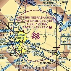
|
CAUTION: Diagram may not be current
 Download PDF
of official airport diagram from the FAA
| Airport distance calculator |
|---|
|
|
| Sunrise and sunset |
|---|
|
Times for 26-Apr-2026
| | Local
(UTC-6) | | Zulu
(UTC) |
|---|
| Morning civil twilight | | 05:29 | | 11:29 |
| Sunrise | | 05:58 | | 11:58 |
| Sunset | | 19:46 | | 01:46 |
| Evening civil twilight | | 20:16 | | 02:16 |
|
| Current date and time |
|---|
| Zulu (UTC) | 27-Apr-2026 00:46:44 |
|---|
| Local (UTC-6) | 26-Apr-2026 18:46:44 |
|---|
|
| METAR |
|---|
| KBFF | 262353Z AUTO 09010KT 10SM BKN011 07/04 A2968 RMK AO2 SLP058 T00670039 10067 20033 58005
|
|
| TAF |
|---|
| KBFF | 261739Z 2618/2718 13009KT P6SM OVC007 FM261900 13010G20KT P6SM BKN010 FM270200 10010KT P6SM VCSH OVC015 FM270800 VRB06KT P6SM OVC010 FM271000 35010KT 2SM BR OVC005
|
|
| NOTAMs |
|---|
NOTAMs are issued by the DoD/FAA and will open in a separate window not controlled by AirNav.
|
|


