FAA INFORMATION EFFECTIVE 17 APRIL 2025
Location
| FAA Identifier: | BIJ |
| Lat/Long: | 31-23-51.0310N 084-53-41.2720W
31-23.850517N 084-53.687867W
31.3975086,-84.8947978
(estimated) |
| Elevation: | 214.6 ft. / 65.4 m (surveyed) |
| Variation: | 03W (2000) |
| From city: | 3 miles E of BLAKELY, GA |
| Time zone: | UTC -4 (UTC -5 during Standard Time) |
| Zip code: | 31723 |
Airport Operations
| Airport use: | Open to the public |
| Activation date: | 01/1968 |
| Control tower: | no |
| ARTCC: | JACKSONVILLE CENTER |
| FSS: | MACON FLIGHT SERVICE STATION |
| NOTAMs facility: | MCN (NOTAM-D service available) |
| Attendance: | MON-FRI 0800-1600 |
| Pattern altitude: | 1201.6 ft. MSL |
| Wind indicator: | lighted |
| Segmented circle: | yes |
| Lights: | ACTVT MALSF RWY 23; PAPI RWYS 05 & 23; MIRL RWY 05/23 - CTAF. |
| Beacon: | white-green (lighted land airport)
Operates sunset to sunrise. |
Airport Communications
| CTAF: | 122.9 |
| WX AWOS-3PT: | 118.475 (229-723-5511) |
| CAIRNS APPROACH: | 125.4 [0645-2300] |
| CAIRNS DEPARTURE: | 125.4 [0645-2300] |
- APCH/DEP SVC PRVDD BY JACKSONVILLE ARTCC ON FREQS 134.3/322.55 (DOTHAN RCAG) WHEN CAIRNS APCH/DEP CLSD.
Nearby radio navigation aids
| VOR radial/distance | | VOR name | | Freq | | Var |
|---|
| RRSr074/28.3 | | WIREGRASS VORTAC | | 111.60 | | 02E |
| PZDr245/34.4 | | PECAN VOR/DME | | 116.10 | | 02W |
| EUFr158/35.3 | | EUFAULA VORTAC | | 109.20 | | 02E |
| MAIr018/38.5 | | MARIANNA VORTAC | | 114.00 | | 00E |
| HEYr091/(38.8) | | HANCHEY VOR | | 110.60 | | 03W |
| NDB name | | Hdg/Dist | | Freq | | Var | | ID |
|---|
| WILLIS | | 327/31.8 | | 359 | | 04W | | LYZ | .-.. -.-- --.. |
Airport Services
| Fuel available: | 100LL JET-A |
| Parking: | hangars and tiedowns |
| Airframe service: | NONE |
| Powerplant service: | NONE |
| Bottled oxygen: | NONE |
| Bulk oxygen: | NONE |
Runway Information
Runway 5/23
| Dimensions: | 5494 x 98 ft. / 1675 x 30 m |
| Surface: | asphalt, in fair condition |
| Weight bearing capacity: | |
| Runway edge lights: | medium intensity |
| RUNWAY 5 | | RUNWAY 23 |
| Latitude: | 31-23.555750N | | 31-24.143685N |
| Longitude: | 084-54.090775W | | 084-53.286805W |
| Elevation: | 214.2 ft. | | 204.7 ft. |
| Traffic pattern: | left | | left |
| Runway heading: | 053 magnetic, 050 true | | 233 magnetic, 230 true |
| Markings: | nonprecision, in fair condition | | nonprecision, in fair condition |
| Visual slope indicator: | 2-light PAPI on left (3.00 degrees glide path) | | 2-light PAPI on left (3.00 degrees glide path) |
| Approach lights: | | | MALSF: 1,400 foot medium intensity approach lighting system with sequenced flashers |
| Touchdown point: | yes, no lights | | yes, no lights |
| Instrument approach: | | | LOCALIZER |
| Obstructions: | 96 ft. trees, 2792 ft. from runway, 480 ft. right of centerline, 27:1 slope to clear | | 82 ft. trees, 1430 ft. from runway, 336 ft. right of centerline, 15:1 slope to clear |
Airport Ownership and Management from official FAA records
| Ownership: | Publicly-owned |
| Owner: | EARLY COUNTY
204 COURT SQUARE
BLAKELY, GA 39823
Phone 229-723-4304 |
| Manager: | STEPHANIE CHANDLER
204 COURT SQUARE
BLAKELY, GA 39823
Phone 229-723-4304 |
Additional Remarks
| - | FOR CD CTC JACKSONVILLE ARTCC AT 904-845-1592. |
Instrument Procedures
NOTE: All procedures below are presented as PDF files. If you need a reader for these files, you should download the free Adobe Reader.NOT FOR NAVIGATION. Please procure official charts for flight.
FAA instrument procedures published for use from 17 April 2025 at 0901Z to 15 May 2025 at 0900z.
IAPs - Instrument Approach Procedures |
|---|
| RNAV (GPS) RWY 05 | |
download (266KB) |
| RNAV (GPS) RWY 23 | |
download (265KB) |
| NOTE: Special Alternate Minimums apply | |
download (154KB) |
| NOTE: Special Take-Off Minimums/Departure Procedures apply | |
download (189KB) |
Other nearby airports with instrument procedures:
KHDL - Headland Municipal Airport (21 nm W)
17J - Donalsonville Municipal Airport (23 nm S)
KBGE - Decatur County Industrial Air Park (29 nm SE)
KDHN - Dothan Regional Airport (29 nm W)
16J - Dawson Municipal Airport (32 nm NE)
|
|

Road maps at:
MapQuest
Bing
Google
| Aerial photo |
|---|
WARNING: Photo may not be current or correct

Do you have a better or more recent aerial photo of Early County Airport that you would like to share? If so, please send us your photo.
|
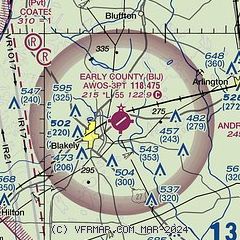
| Sectional chart |
|---|
|
| Airport distance calculator |
|---|
|
|
| Sunrise and sunset |
|---|
|
Times for 07-May-2025
| | Local
(UTC-4) | | Zulu
(UTC) |
|---|
| Morning civil twilight | | 06:24 | | 10:24 |
| Sunrise | | 06:50 | | 10:50 |
| Sunset | | 20:22 | | 00:22 |
| Evening civil twilight | | 20:48 | | 00:48 |
|
| Current date and time |
|---|
| Zulu (UTC) | 07-May-2025 10:26:46 |
|---|
| Local (UTC-4) | 07-May-2025 06:26:46 |
|---|
|
| METAR |
|---|
| KBIJ | 071015Z AUTO 00000KT 10SM -DZ OVC110 19/13 A3006 RMK AO2
|
|
| TAF |
|---|
KDHN
29nm W | 070523Z 0706/0806 VRB03KT P6SM BKN100 FM071000 VRB04KT 5SM -SHRA BR BKN025 OVC050 FM071700 20009KT P6SM SCT040 BKN100 PROB30 0719/0801 6SM -TSRA BKN040CB
|
|
| NOTAMs |
|---|
NOTAMs are issued by the DoD/FAA and will open in a separate window not controlled by AirNav.
|
|


