FAA INFORMATION EFFECTIVE 14 MAY 2026
Location
| FAA Identifier: | BMI |
| Lat/Long: | 40-28-37.6000N 088-54-57.3000W
40-28.626667N 088-54.955000W
40.4771111,-88.9159167
(estimated) |
| Elevation: | 871.4 ft. / 265.6 m (surveyed) |
| Variation: | 03W (2015) |
| From city: | 3 miles E of central business district of the associated city |
| Time zone: | UTC -5 (UTC -6 during Standard Time) |
| Zip code: | 61704 |
Airport Operations
| Airport use: | Open to the public |
| Activation date: | 04/1940 |
| Control tower: | yes |
| ARTCC: | KANSAS CITY CENTER |
| FSS: | KANKAKEE FLIGHT SERVICE STATION |
| NOTAMs facility: | BMI (NOTAM-D service available) |
| Attendance: | 0400L-2400L |
| Wind indicator: | lighted |
| Segmented circle: | no |
| Lights: | ACTVT MALSR RWY 02 & 29; TDZ RWY 20; CNTLN 02/20; PAPI RWY 02; HIRL RWY 02/20 & 11/29 - CTAF. ALSF AVBL WHEN ATCT OPEN. |
| Beacon: | white-green (lighted land airport)
Operates sunset to sunrise. |
| Fire and rescue: | ARFF index B |
| Airline operations: | 48 HR PPR FOR UNSKED ACR OPS MORE THAN 30 PAX SEATS - AMGR. |
Airport Communications
| CTAF: | 124.6 |
| UNICOM: | 122.95 |
| ATIS: | 119.575 |
| WX AWOS-3PT: | 135.35 (309-661-9478) |
| BLOOMINGTON GROUND: | 121.65 [0600-2200] |
| BLOOMINGTON TOWER: | 124.6 269.575 [0600-2200] |
| SAINT LOUIS APPROACH: | 128.725 |
| SAINT LOUIS DEPARTURE: | 128.725 |
| EMERG: | 121.5 |
Nearby radio navigation aids
| VOR radial/distance | | VOR name | | Freq | | Var |
|---|
| RBSr258/34.8 | | ROBERTS VOR/DME | | 116.80 | | 02E |
| CMIr309/39.5 | | CHAMPAIGN VORTAC | | 115.75 | | 03E |
| NDB name | | Hdg/Dist | | Freq | | Var | | ID |
|---|
| EGROW | | 204/5.3 | | 334 | | 03W | | LH | .-.. .... |
| ABRAHAM | | 045/27.1 | | 329 | | 00E | | AAA | .- .- .- |
Airport Services
| Fuel available: | 100LL JET-A |
| Parking: | hangars and tiedowns |
| Airframe service: | MAJOR |
| Powerplant service: | MAJOR |
| Bottled oxygen: | LOW |
Runway Information
Runway 2/20
| Dimensions: | 8000 x 150 ft. / 2438 x 46 m |
| Surface: | concrete/grooved, in good condition |
| Weight bearing capacity: | | Single wheel: | 120.0 | | Double wheel: | 211.0 | | Double tandem: | 322.0 | | Dual double tandem: | 753.0 |
|
| Runway edge lights: | high intensity |
| RUNWAY 2 | | RUNWAY 20 |
| Latitude: | 40-27.843008N | | 40-29.096698N |
| Longitude: | 088-54.961520W | | 088-54.431047W |
| Elevation: | 856.4 ft. | | 862.5 ft. |
| Traffic pattern: | left | | left |
| Runway heading: | 021 magnetic, 018 true | | 201 magnetic, 198 true |
| Declared distances: | TORA:8000 TODA:8000 ASDA:8000 LDA:8000 | | TORA:8000 TODA:8000 ASDA:8000 LDA:8000 |
| Markings: | precision, in fair condition | | precision, in fair condition |
| Visual slope indicator: | 4-light PAPI on right (3.00 degrees glide path) | | |
| RVR equipment: | touchdown, midfield, rollout | | touchdown, midfield, rollout |
| Approach lights: | MALSR: 1,400 foot medium intensity approach lighting system with runway alignment indicator lights | | ALSF2: standard 2,400 foot high intensity approach lighting system with centerline sequenced flashers (category II or III)
WHEN ATCT CLSD ALSF2 OPR AS SSALR. |
| Centerline lights: | yes | | yes |
| Touchdown point: | yes, no lights | | yes, lighted |
| Instrument approach: | ILS/DME | | ILS/DME |
| Obstructions: | none | | 40 ft. pline, 2007 ft. from runway, 770 ft. left of centerline, 45:1 slope to clear |
Runway 11/29
| Dimensions: | 6525 x 150 ft. / 1989 x 46 m
SE END 565 FT CONC; RMNG 5960 FT ASPH. |
| Surface: | asphalt/concrete/grooved, in good condition |
| Weight bearing capacity: | | Single wheel: | 120.0 | | Double wheel: | 216.0 | | Double tandem: | 349.0 | | Dual double tandem: | 814.0 |
|
| Runway edge lights: | high intensity |
| RUNWAY 11 | | RUNWAY 29 |
| Latitude: | 40-28.984202N | | 40-28.654173N |
| Longitude: | 088-55.940557W | | 088-54.601402W |
| Elevation: | 871.4 ft. | | 871.1 ft. |
| Traffic pattern: | left | | left |
| Runway heading: | 110 magnetic, 107 true | | 290 magnetic, 287 true |
| Declared distances: | TORA:6525 TODA:6525 ASDA:6525 LDA:6525 | | TORA:6525 TODA:6525 ASDA:6525 LDA:6525 |
| Markings: | precision, in good condition | | precision, in good condition |
| Visual slope indicator: | 4-box VASI on right (3.00 degrees glide path) | | |
| RVR equipment: | rollout | | touchdown |
| Approach lights: | | | MALSR: 1,400 foot medium intensity approach lighting system with runway alignment indicator lights |
| Runway end identifier lights: | no | | no |
| Touchdown point: | yes, no lights | | yes, no lights |
| Instrument approach: | | | ILS/DME |
Airport Ownership and Management from official FAA records
| Ownership: | Publicly-owned |
| Owner: | CENTRAL ILLINOIS REGIONAL ARPT AUTH
3201 CIRA DRIVE
BLOOMINGTON, IL 61704
Phone 309-663-7383 |
| Manager: | CARL G. OLSON
3201 CIRA DRIVE
BLOOMINGTON, IL 61704
Phone 309-663-7383 |
Additional Remarks
| A39-11/29 | PCR VALUE: 700/R/C/W/T |
| A39-02/20 | PCR VALUE: 700/R/D/W/T |
| - | BIRDS ON & INVOF ARPT. |
| - | SNOW REMOVAL OPS WINTER MONTHS; WHEN ATCT CLSD MNT CTAF. |
| - | WHEN ATCT CLSD LNDG/TKOF ANNOUNCE INTENTIONS ON CTAF. |
| - | ARPT OPS H24 - 309-834-7396. |
Instrument Procedures
NOTE: All procedures below are presented as PDF files. If you need a reader for these files, you should download the free Adobe Reader.NOT FOR NAVIGATION. Please procure official charts for flight.
FAA instrument procedures published for use from 14 May 2026 at 0901Z to 11 June 2026 at 0900Z.
IAPs - Instrument Approach Procedures |
|---|
| ILS OR LOC RWY 02 | |
download (289KB) |
| ILS OR LOC RWY 20 | |
download (296KB) |
| ILS OR LOC RWY 29 | |
download (297KB) |
| ILS RWY 20 (CAT II) | |
download (221KB) |
| RNAV (GPS) RWY 02 | |
download (314KB) |
| RNAV (GPS) RWY 11 | |
download (248KB) |
| RNAV (GPS) RWY 20 | |
download (272KB) |
| RNAV (GPS) RWY 29 | |
download (275KB) |
| LOC BC RWY 11 | |
download (235KB) |
| NOTE: Special Alternate Minimums apply | |
download (162KB) |
| NOTE: Special Take-Off Minimums/Departure Procedures apply | |
download (482KB) |
Other nearby airports with instrument procedures:
KAAA - Logan County Airport (27 nm SW)
KPNT - Pontiac Municipal Airport (30 nm NE)
C15 - Pekin Municipal Airport (35 nm W)
1C1 - Paxton Airport (36 nm E)
KTIP - Rantoul National Aviation Center Airport-Frank Elliott Field (37 nm E)
|
|

Road maps at:
MapQuest
Bing
Google
| Aerial photo |
|---|
WARNING: Photo may not be current or correct
 Photo by Bob Tridle
Do you have a better or more recent aerial photo of Central Illinois Regional Airport/Bloomington-Normal that you would like to share? If so, please send us your photo.
|
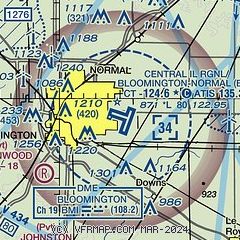
| Sectional chart |
|---|
|
CAUTION: Diagram may not be current
 Download PDF
of official airport diagram from the FAA
| Airport distance calculator |
|---|
|
|
| Sunrise and sunset |
|---|
|
Times for 08-Jun-2026
| | Local
(UTC-5) | | Zulu
(UTC) |
|---|
| Morning civil twilight | | 04:53 | | 09:53 |
| Sunrise | | 05:26 | | 10:26 |
| Sunset | | 20:23 | | 01:23 |
| Evening civil twilight | | 20:56 | | 01:56 |
|
| Current date and time |
|---|
| Zulu (UTC) | 08-Jun-2026 06:15:55 |
|---|
| Local (UTC-5) | 08-Jun-2026 01:15:55 |
|---|
|
| METAR |
|---|
| KBMI | 080556Z AUTO 10005KT 10SM CLR 22/22 A2994 RMK AO2 SLP128 60011 T02170217 10267 20217 402890206 58001
|
|
| TAF |
|---|
| KBMI | 080522Z 0806/0906 12009KT P6SM SCT050 BKN120 FM081000 14011KT P6SM -SHRA BKN040 FM081400 15013KT P6SM VCSH BKN018 FM081800 18013KT P6SM VCSH BKN045 TEMPO 0820/0824 4SM TSRA BKN045CB FM090000 19008KT P6SM BKN050
|
|
| NOTAMs |
|---|
NOTAMs are issued by the DoD/FAA and will open in a separate window not controlled by AirNav.
|
|


