FAA INFORMATION EFFECTIVE 14 MAY 2026
Location
| FAA Identifier: | AAA |
| Lat/Long: | 40-09-31.3000N 089-20-06.1000W
40-09.521667N 089-20.101667W
40.1586944,-89.3350278
(estimated) |
| Elevation: | 594.3 ft. / 181.1 m (surveyed) |
| Variation: | 00E (1990) |
| From city: | 2 miles NE of LINCOLN, IL |
| Time zone: | UTC -5 (UTC -6 during Standard Time) |
| Zip code: | 62656 |
Airport Operations
| Airport use: | Open to the public |
| Activation date: | 04/1950 |
| Control tower: | no |
| ARTCC: | KANSAS CITY CENTER |
| FSS: | SAINT LOUIS FLIGHT SERVICE STATION |
| NOTAMs facility: | AAA (NOTAM-D service available) |
| Attendance: | MON-SAT IREG
FOR SVC CALL 309-838-5694 OR 217-737-3517. |
| Wind indicator: | lighted |
| Segmented circle: | no |
| Lights: | ACTVT REIL RWY 03; PAPI RWY 03 & 21; MIRL RWY 03/21 - CTAF. |
| Beacon: | white-green (lighted land airport)
Operates sunset to sunrise. |
Airport Communications
| CTAF/UNICOM: | 122.8 |
| WX AWOS-3: | 118.775 (217-732-9605) |
| SAINT LOUIS APPROACH: | 126.15 |
| SAINT LOUIS DEPARTURE: | 126.15 |
Nearby radio navigation aids
| VOR radial/distance | | VOR name | | Freq | | Var |
|---|
| SPIr040/24.8 | | SPINNER VORTAC | | 112.70 | | 01W |
| AXCr316/33.5 | | ADDERS VORTAC | | 117.20 | | 03E |
| PIAr142/37.6 | | PEORIA VORTAC | | 115.20 | | 04E |
| NDB name | | Hdg/Dist | | Freq | | Var | | ID |
|---|
| ABRAHAM | | at field | | 329 | | 00E | | AAA | .- .- .- |
Airport Services
| Fuel available: | 100LL |
| Parking: | hangars and tiedowns |
| Airframe service: | MAJOR |
| Powerplant service: | MAJOR |
| Bottled oxygen: | NONE |
| Bulk oxygen: | NONE |
Runway Information
Runway 3/21
| Dimensions: | 4000 x 75 ft. / 1219 x 23 m
225 FT STWY NE END. |
| Surface: | asphalt, in excellent condition |
| Weight bearing capacity: | |
| Runway edge lights: | medium intensity |
| RUNWAY 3 | | RUNWAY 21 |
| Latitude: | 40-09.198638N | | 40-09.736320N |
| Longitude: | 089-20.397753W | | 089-19.901758W |
| Elevation: | 592.6 ft. | | 594.3 ft. |
| Traffic pattern: | left | | left |
| Runway heading: | 035 | | 215 |
| Markings: | nonprecision, in good condition | | nonprecision, in good condition |
| Visual slope indicator: | 4-light PAPI on left (3.50 degrees glide path) | | 4-light PAPI on left (3.00 degrees glide path) |
| Runway end identifier lights: | yes | | no |
| Touchdown point: | yes, no lights | | yes, no lights |
| Obstructions: | none
CHURCH STEEPLE 21:1. | | 49 ft. tree, 1059 ft. from runway, 200 ft. right of centerline, 17:1 slope to clear |
Runway 14/32
| Dimensions: | 3021 x 135 ft. / 921 x 41 m |
| Surface: | turf, in good condition |
| Operational restrictions: | PPR TO USE DEC-APR & AFT RAIN CALL 217-732-6400. |
| RUNWAY 14 | | RUNWAY 32 |
| Latitude: | 40-09.797300N | | 40-09.392570N |
| Longitude: | 089-20.225675W | | 089-19.848353W |
| Elevation: | 590.5 ft. | | 589.0 ft. |
| Traffic pattern: | left | | left |
| Runway heading: | 144 | | 324 |
| Displaced threshold: | 307 ft. | | no |
| Runway end identifier lights: | no | | no |
| Touchdown point: | yes, no lights | | yes, no lights |
| Obstructions: | 57 ft. trees, 797 ft. from runway, 52 ft. right of centerline, 13:1 slope to clear
APP SLP TO DTHR 19:1, RWY 21 APCH SLP TO RWY END IS 21:1. | | 13 ft. road, 260 ft. from runway, 148 ft. right of centerline, 20:1 slope to clear |
Airport Ownership and Management from official FAA records
| Ownership: | Publicly-owned |
| Owner: | LOGAN COUNTY BOARD
COUNTY COURTHOUSE, P.O. BOX 39
LINCOLN, IL 62656
Phone 217-732-6400 |
| Manager: | GENE ROHLFS
COUNTY COURT HOUSE, P.O. BOX 39
LINCOLN, IL 62656
Phone 217-732-6400 |
Additional Remarks
| - | TEMPO AND LONG-TERM HNGR SPACE AVBL - DLY, WEEKLY, MONTHLY, YEARLY. |
| - | FOR CD CTC ST LOUIS APCH 314-890-1017. |
| - | (CONTACT PHONE NR) ADDITIONAL OPERATOR PHONE NUMBER: 217-737-3517. |
Instrument Procedures
NOTE: All procedures below are presented as PDF files. If you need a reader for these files, you should download the free Adobe Reader.NOT FOR NAVIGATION. Please procure official charts for flight.
FAA instrument procedures published for use from 14 May 2026 at 0901Z to 11 June 2026 at 0900Z.
IAPs - Instrument Approach Procedures |
|---|
| RNAV (GPS) RWY 03 | |
download (212KB) |
| RNAV (GPS) RWY 21 | |
download (184KB) |
| NOTE: Special Alternate Minimums apply **CHANGED** | |
download (162KB) |
| NOTE: Special Take-Off Minimums/Departure Procedures apply | |
download (317KB) |
Other nearby airports with instrument procedures:
KSPI - Abraham Lincoln Capital Airport (25 nm SW)
C15 - Pekin Municipal Airport (25 nm NW)
KBMI - Central Illinois Regional Airport/Bloomington-Normal (27 nm NE)
KDEC - Decatur Airport (29 nm SE)
KPIA - General Downing - Peoria International Airport (34 nm NW)
|
|

Road maps at:
MapQuest
Bing
Google
| Aerial photo |
|---|
WARNING: Photo may not be current or correct
 Photo taken 01-Jul-2008
Do you have a better or more recent aerial photo of Logan County Airport that you would like to share? If so, please send us your photo.
|
| Sectional chart |
|---|
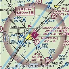
|
| Airport distance calculator |
|---|
|
|
| Sunrise and sunset |
|---|
|
Times for 27-May-2026
| | Local
(UTC-5) | | Zulu
(UTC) |
|---|
| Morning civil twilight | | 05:02 | | 10:02 |
| Sunrise | | 05:34 | | 10:34 |
| Sunset | | 20:15 | | 01:15 |
| Evening civil twilight | | 20:47 | | 01:47 |
|
| Current date and time |
|---|
| Zulu (UTC) | 27-May-2026 16:26:02 |
|---|
| Local (UTC-5) | 27-May-2026 11:26:02 |
|---|
|
| METAR |
|---|
| KAAA | 271555Z AUTO 03006KT 10SM CLR 27/15 A3001 RMK AO2 T02680147
|
|
| TAF |
|---|
KSPI
24nm SW | 271120Z 2712/2812 03006KT P6SM SCT060 OVC100 FM272100 05006KT P6SM SCT250
|
KBMI
27nm NE | 271120Z 2712/2812 02008KT P6SM SCT100 BKN250 FM271900 05009KT P6SM SCT250
|
KDEC
30nm SE | 271120Z 2712/2812 03007KT P6SM -RA OVC040 FM271500 03009KT P6SM BKN040 FM272100 05006KT P6SM BKN250
|
|
| NOTAMs |
|---|
NOTAMs are issued by the DoD/FAA and will open in a separate window not controlled by AirNav.
|
|

