FAA INFORMATION EFFECTIVE 14 MAY 2026
Location
| FAA Identifier: | BRD |
| Lat/Long: | 46-24-15.2000N 094-08-01.7000W
46-24.253333N 094-08.028333W
46.4042222,-94.1338056
(estimated) |
| Elevation: | 1232.2 ft. / 375.6 m (surveyed) |
| Variation: | 03E (1995) |
| From city: | 3 miles NE of BRAINERD, MN |
| Time zone: | UTC -5 (UTC -6 during Standard Time) |
| Zip code: | 56401 |
Airport Operations
| Airport use: | Open to the public |
| Activation date: | 10/1948 |
| Control tower: | no |
| ARTCC: | MINNEAPOLIS CENTER |
| FSS: | PRINCETON FLIGHT SERVICE STATION |
| NOTAMs facility: | BRD (NOTAM-D service available) |
| Attendance: | JUL-OCT 0500-2300, NOV-JUN 0500-2300 |
| Wind indicator: | lighted |
| Segmented circle: | yes |
| Lights: | HIRL RWY 05/23 & HIRL RWY 16/34 PRESET ON LOW INTST; TO INCR INTST & ACTVT REIL RWY 05 & 16 AND MALSR RWY 23 & 34 - CTAF. |
| Beacon: | white-green (lighted land airport)
Operates sunset to sunrise. |
| Fire and rescue: | ARFF index A |
Airport Communications
| CTAF/UNICOM: | 122.7 |
| WX ASOS: | 126.775 (218-828-3314) |
- APCH/DEP SVC PRVDD BY MINNEAPOLIS ARTCC ON FREQS 118.05/239.0 (BRAINERD RCAG).
Nearby radio navigation aids
| NDB name | | Hdg/Dist | | Freq | | Var | | ID |
|---|
| LAREW | | 233/5.6 | | 251 | | 03E | | BR | -... .-. |
| RIPLEY | | 021/21.4 | | 404 | | 03E | | XCR | -..- -.-. .-. |
Airport Services
| Fuel available: | 100LL JET-A |
| Parking: | hangars and tiedowns |
| Airframe service: | MAJOR |
| Powerplant service: | MAJOR |
| Bottled oxygen: | HIGH |
| Bulk oxygen: | HIGH |
Runway Information
Runway 16/34
| Dimensions: | 7100 x 150 ft. / 2164 x 46 m |
| Surface: | concrete/grooved, in excellent condition |
| Weight bearing capacity: | | Single wheel: | 75.0 | | Double wheel: | 125.0 | | Double tandem: | 220.0 |
|
| Runway edge lights: | high intensity |
| RUNWAY 16 | | RUNWAY 34 |
| Latitude: | 46-25.046785N | | 46-23.931862N |
| Longitude: | 094-08.161823W | | 094-07.658290W |
| Elevation: | 1226.2 ft. | | 1232.2 ft. |
| Traffic pattern: | left | | left |
| Runway heading: | 160 magnetic, 163 true | | 340 magnetic, 343 true |
| Markings: | precision, in good condition | | precision, in good condition |
| Visual slope indicator: | 4-light PAPI on left (3.00 degrees glide path) | | 4-light PAPI on right (3.00 degrees glide path) |
| Approach lights: | | | MALSR: 1,400 foot medium intensity approach lighting system with runway alignment indicator lights |
| Runway end identifier lights: | yes | | no |
| Touchdown point: | yes, no lights | | yes, no lights |
| Instrument approach: | | | ILS/DME |
Runway 5/23
| Dimensions: | 6512 x 150 ft. / 1985 x 46 m |
| Surface: | concrete/grooved, in good condition |
| Weight bearing capacity: | | Single wheel: | 75.0 | | Double wheel: | 125.0 | | Double tandem: | 220.0 |
|
| Runway edge lights: | high intensity |
| RUNWAY 5 | | RUNWAY 23 |
| Latitude: | 46-23.677788N | | 46-24.314495N |
| Longitude: | 094-08.779362W | | 094-07.533918W |
| Elevation: | 1220.3 ft. | | 1222.6 ft. |
| Traffic pattern: | left | | left |
| Runway heading: | 051 magnetic, 054 true | | 231 magnetic, 234 true |
| Markings: | precision, in good condition | | precision, in good condition |
| Visual slope indicator: | 4-box VASI on left (3.00 degrees glide path) | | 4-light PAPI on left (3.00 degrees glide path)
PAPI UNUSBL BYD 9 DEG RIGHT OF CRS. |
| Approach lights: | | | MALSR: 1,400 foot medium intensity approach lighting system with runway alignment indicator lights |
| Runway end identifier lights: | yes | | no |
| Touchdown point: | yes, no lights | | yes, no lights |
| Instrument approach: | | | ILS |
| Obstructions: | none | | 68 ft. trees, 2803 ft. from runway, 800 ft. left of centerline, 38:1 slope to clear |
Helipad H1
| Dimensions: | 60 x 60 ft. / 18 x 18 m |
| Surface: | concrete/grooved, in good condition |
| Runway edge lights: | PERI |
| Latitude: | 46-23.348833N | | |
| Longitude: | 094-08.332500W | | |
| Elevation: | 1226.0 ft. | | |
| Traffic pattern: | left | | left |
| Markings: | basic, in good condition | | |
Airport Ownership and Management from official FAA records
| Ownership: | Publicly-owned |
| Owner: | BRAINERD/CROW WING CNTY
16384 AIRPORT RD, SUITE 5
BRAINERD, MN 56401
Phone 218-825-2166 |
| Manager: | JENNIFER ROACH
BRAINERD LAKES REGIONAL ARPT, 16384 AIRPORT RD SUITE 5
BRAINERD, MN 56401
Phone 218-825-2166
SWRIGHT@BRAINERDAIRPORT.COM. |
Additional Remarks
| A39-05/23 | PCR VALUE: 170/R/A/W/T |
| A39-16/34 | PCR VALUE: 320/R/A/W/T |
| A30A-34 | CALM WIND RWY. |
| - | DEER AND GULLS ON & INVOF ARPT. |
| - | FOR ATNDC OTHER HRS, SEE FONE LISTING IN PILOT LOUNGE, 218-829-3398. |
| - | PPR FOR UNSKED ACR OPNS WITH MORE THAN 30 PSGR SEATS CALL AMGR 218-825-2166 BTN 0800-1700. ACR OPNS INVOLVING ACFT WITH MORE THAN 30 PSGRS ARE NOT AUZD IN EXCESS OF 15 MINS BEFORE OR AFTER SKEDD ARR/DEP TIMES WITHOUT PRIOR COORDINATION WITH AMGR AND CFMN THAT ARFF IS AVBL PRIOR TO LNDG OR TKOF. |
| - | FOR CD IF UNA TO CTC ON FSS FREQ, CTC MINNEAPOLIS ARTCC AT 651-463-5588. |
Instrument Procedures
NOTE: All procedures below are presented as PDF files. If you need a reader for these files, you should download the free Adobe Reader.NOT FOR NAVIGATION. Please procure official charts for flight.
FAA instrument procedures published for use from 14 May 2026 at 0901Z to 11 June 2026 at 0900Z.
IAPs - Instrument Approach Procedures |
|---|
| ILS OR LOC RWY 23 | |
download (268KB) |
| ILS OR LOC RWY 34 | |
download (293KB) |
| RNAV (GPS) RWY 05 | |
download (262KB) |
| RNAV (GPS) RWY 23 | |
download (270KB) |
| RNAV (GPS) RWY 34 | |
download (283KB) |
| NOTE: Special Alternate Minimums apply | |
download (81KB) |
| NOTE: Special Take-Off Minimums/Departure Procedures apply | |
download (156KB) |
Other nearby airports with instrument procedures:
KAIT - Aitkin Municipal Airport - Steve Kurtz Field (21 nm NE)
KRYM - Ray S Miller Army Airfield (21 nm SW)
KPWC - Pine River Regional Airport (22 nm NW)
KSAZ - Staples Municipal Airport (28 nm W)
KLXL - Little Falls/Morrison County Airport-Lindbergh Field (29 nm S)
|
|

Road maps at:
MapQuest
Bing
Google
| Aerial photo |
|---|
WARNING: Photo may not be current or correct
 Photo by Andrew Dunlap
Photo taken 03-Nov-2011
looking north.
Photo by Andrew Dunlap
Photo taken 03-Nov-2011
looking north.
Do you have a better or more recent aerial photo of Brainerd Lakes Regional Airport that you would like to share? If so, please send us your photo.
|
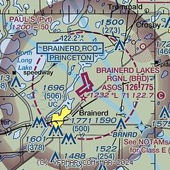
| Sectional chart |
|---|
|
| Airport distance calculator |
|---|
|
|
| Sunrise and sunset |
|---|
|
Times for 05-Jun-2026
| | Local
(UTC-5) | | Zulu
(UTC) |
|---|
| Morning civil twilight | | 04:48 | | 09:48 |
| Sunrise | | 05:27 | | 10:27 |
| Sunset | | 21:03 | | 02:03 |
| Evening civil twilight | | 21:42 | | 02:42 |
|
| Current date and time |
|---|
| Zulu (UTC) | 05-Jun-2026 21:56:58 |
|---|
| Local (UTC-5) | 05-Jun-2026 16:56:58 |
|---|
|
| METAR |
|---|
| KBRD | 052053Z AUTO VRB04KT 10SM SCT110 24/15 A2977 RMK AO2 SLP078 T02440150 58007 $
|
|
| TAF |
|---|
| KBRD | 051950Z 0520/0618 27006KT P6SM VCSH SCT030 PROB30 0520/0523 3SM -TSRA SCT025CB OVC070 FM060100 VRB03KT P6SM SCT150 FM060800 00000KT 1 1/2SM BR FEW002 FM061300 00000KT P6SM SKC
|
|
| NOTAMs |
|---|
NOTAMs are issued by the DoD/FAA and will open in a separate window not controlled by AirNav.
|
|


