FAA INFORMATION EFFECTIVE 14 MAY 2026
Location
| FAA Identifier: | BUY |
| Lat/Long: | 36-02-59.0200N 079-28-22.8290W
36-02.983667N 079-28.380483W
36.0497278,-79.4730081
(estimated) |
| Elevation: | 616.1 ft. / 187.8 m (surveyed) |
| Variation: | 08W (2000) |
| From city: | 3 miles SW of BURLINGTON, NC |
| Time zone: | UTC -4 (UTC -5 during Standard Time) |
| Zip code: | 27215 |
Airport Operations
| Airport use: | Open to the public |
| Activation date: | 03/1943 |
| Control tower: | no |
| ARTCC: | ATLANTA CENTER |
| FSS: | RALEIGH FLIGHT SERVICE STATION |
| NOTAMs facility: | BUY (NOTAM-D service available) |
| Attendance: | 0800-2000
UNATNDD CHRISTMAS DAY. |
| Wind indicator: | lighted |
| Segmented circle: | yes |
| Lights: | ACTVT REIL RWY 06 & 24 - CTAF. PAPI RWY 06 & 24 OPER CONT. HIRL RWY 06/24 ON DUSK-DAWN, TO CHANGE INTST - CTAF. |
| Beacon: | white-green (lighted land airport)
Operates sunset to sunrise. |
Airport Communications
| CTAF/UNICOM: | 122.975 |
| WX ASOS: | 135.325 (336-570-9813) |
| GREENSBORO APPROACH: | 126.6 [0630-2300] |
| GREENSBORO DEPARTURE: | 126.6 [0630-2300] |
| CLEARANCE DELIVERY: | 120.25 |
Nearby radio navigation aids
| VOR radial/distance | | VOR name | | Freq | | Var |
|---|
| LIBr028/15.8 | | LIBERTY VORTAC | | 113.00 | | 03W |
| GSOr092/24.4 | | GREENSBORO VORTAC | | 116.20 | | 03W |
| RDUr297/35.1 | | RALEIGH/DURHAM VORTAC | | 117.20 | | 09W |
| NDB name | | Hdg/Dist | | Freq | | Var | | ID |
|---|
| ALAMM | | 060/6.9 | | 361 | | 08W | | HB | .... -... |
| SLAMMER | | 152/24.4 | | 423 | | 07W | | SIF | ... .. ..-. |
Airport Services
| Fuel available: | 100LL JET-A1+ |
| Parking: | hangars and tiedowns |
| Airframe service: | MAJOR |
| Powerplant service: | MAJOR |
| Bottled oxygen: | HIGH |
| Bulk oxygen: | NONE |
Runway Information
Runway 6/24
| Dimensions: | 6406 x 100 ft. / 1953 x 30 m |
| Surface: | asphalt, in excellent condition |
| Weight bearing capacity: | | PCN 29 /F/C/W/T | | Single wheel: | 73.0 | | Double wheel: | 97.0 | | Double tandem: | 57.0 |
|
| Runway edge lights: | high intensity |
| RUNWAY 6 | | RUNWAY 24 |
| Latitude: | 36-02.659493N | | 36-03.307795N |
| Longitude: | 079-28.893502W | | 079-27.867400W |
| Elevation: | 615.9 ft. | | 586.7 ft. |
| Traffic pattern: | left | | left |
| Runway heading: | 060 magnetic, 052 true | | 240 magnetic, 232 true |
| Markings: | precision, in good condition | | precision, in good condition |
| Visual slope indicator: | 4-light PAPI on left (3.00 degrees glide path) | | 4-light PAPI on left (3.00 degrees glide path) |
| Runway end identifier lights: | yes | | yes |
| Touchdown point: | yes, no lights | | yes, no lights |
| Instrument approach: | ILS | | |
| Obstructions: | 38 ft. trees, 1161 ft. from runway, 450 ft. left of centerline, 25:1 slope to clear
16 FT TREES 116 FT FM END OF RWY OFFSET 363 FT RIGHT OF CNTRLN. | | 51 ft. trees, 1505 ft. from runway, 596 ft. left of centerline, 25:1 slope to clear |
Airport Ownership and Management from official FAA records
| Ownership: | Publicly-owned |
| Owner: | BURLINGTON-ALAMANCE AIRPORT AUTHORI
3441 N. AVIATION DR.
BURLINGTON, NC 27215
Phone 336-227-0771 |
| Manager: | DAN DANIELEY
3441. N AVIATION DRIVE
BURLINGTON, NC 27215-6374
Phone 336-227-0771
ARPT PH# 336-226-3330. |
Additional Remarks
| - | DEER AND WATERFOWL INVOF ARPT. |
| - | RWY 06, 15 FT DROP-OFF 150 FT FM THR 250 FT LEFT OF CNTRLN. |
| - | AFTER HRS FUEL OR EMERG ONLY 336-223-4994. |
| - | FOR CD CTC GREENSBORO APCH AT 743-222-6129. |
| - | RWY 24 HAS UNMKD HIGH VOLTAGE TRANSMISSION LINES APRXLY 4000 FT FROM THR AND BOTH SIDES OF CNTRLN. |
Instrument Procedures
NOTE: All procedures below are presented as PDF files. If you need a reader for these files, you should download the free Adobe Reader.NOT FOR NAVIGATION. Please procure official charts for flight.
FAA instrument procedures published for use from 14 May 2026 at 0901Z to 11 June 2026 at 0900Z.
IAPs - Instrument Approach Procedures |
|---|
| ILS Y OR LOC Y RWY 06 | |
download (250KB) |
| ILS Z OR LOC Z RWY 06 | |
download (244KB) |
| RNAV (GPS) RWY 06 | |
download (241KB) |
| RNAV (GPS) RWY 24 | |
download (251KB) |
| VOR/DME-A | |
download (193KB) |
| NOTE: Special Alternate Minimums apply | |
download (142KB) |
| NOTE: Special Take-Off Minimums/Departure Procedures apply | |
download (356KB) |
Other nearby airports with instrument procedures:
KSCR - Siler City Municipal Airport (21 nm S)
KGSO - Piedmont Triad International Airport (23 nm W)
KTDF - Raleigh Regional Airport at Person County (28 nm NE)
KSIF - Rockingham County NC Shiloh Airport (30 nm NW)
KHBI - Asheboro Regional Airport (31 nm SW)
|
|

Road maps at:
MapQuest
Bing
Google
| Aerial photo |
|---|
WARNING: Photo may not be current or correct
 Photo by Gregory York
Photo taken 17-Mar-2012
looking West at 5,000 MSL.
Photo by Gregory York
Photo taken 17-Mar-2012
looking West at 5,000 MSL.
Do you have a better or more recent aerial photo of Burlington/Alamance Regional Airport that you would like to share? If so, please send us your photo.
|
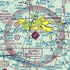
| Sectional chart |
|---|
|
CAUTION: Diagram may not be current

| Airport distance calculator |
|---|
|
|
| Sunrise and sunset |
|---|
|
Times for 18-May-2026
| | Local
(UTC-4) | | Zulu
(UTC) |
|---|
| Morning civil twilight | | 05:42 | | 09:42 |
| Sunrise | | 06:11 | | 10:11 |
| Sunset | | 20:18 | | 00:18 |
| Evening civil twilight | | 20:47 | | 00:47 |
|
| Current date and time |
|---|
| Zulu (UTC) | 18-May-2026 10:52:08 |
|---|
| Local (UTC-4) | 18-May-2026 06:52:08 |
|---|
|
| METAR |
|---|
| KBUY | 180954Z AUTO 00000KT 9SM CLR 17/17 A3020 RMK AO2 SLP220 T01720167
|
|
| TAF |
|---|
KGSO
23nm W | 180520Z 1806/1906 22005KT P6SM SKC
|
|
| NOTAMs |
|---|
NOTAMs are issued by the DoD/FAA and will open in a separate window not controlled by AirNav.
|
|


