FAA INFORMATION EFFECTIVE 19 MARCH 2026
Location
| FAA Identifier: | CBF |
| Lat/Long: | 41-15-36.4000N 095-45-31.1000W
41-15.606667N 095-45.518333W
41.2601111,-95.7586389
(estimated) |
| Elevation: | 1244.8 ft. / 379.4 m (surveyed) |
| Variation: | 05E (2000) |
| From city: | 4 miles E of COUNCIL BLUFFS, IA |
| Time zone: | UTC -5 (UTC -6 during Standard Time) |
| Zip code: | 51503 |
Airport Operations
| Airport use: | Open to the public |
| Activation date: | 11/1967 |
| Control tower: | no |
| ARTCC: | MINNEAPOLIS CENTER |
| FSS: | FORT DODGE FLIGHT SERVICE STATION |
| NOTAMs facility: | CBF (NOTAM-D service available) |
| Attendance: | 0700-2000 |
| Wind indicator: | lighted |
| Segmented circle: | no |
| Lights: | ACTVT MIRL RWY 14/32; HIRL RWY 18/36; REIL RWYS 14, 32, 18 & 36 - CTAF. PAPI RWYS 14, 32, 18 & 36 ARE ON 24/7. |
| Beacon: | white-green (lighted land airport)
Operates sunset to sunrise. |
Airport Communications
| CTAF/UNICOM: | 122.725 |
| WX AWOS-3: | 126.575 (712-323-1542) |
| OMAHA APPROACH: | 124.5 [0500-2330] |
| OMAHA DEPARTURE: | 124.5 [0500-2330] |
| CLEARANCE DELIVERY: | 127.675 |
| WX ASOS at OMA (7 nm NW): | PHONE 402-271-7515 |
| WX AWOS-3 at MLE (16 nm W): | 118.25 (402-895-6778) |
| WX AWOS-3 at BTA (18 nm NW): | 120.225 (402-426-0448) |
Nearby radio navigation aids
| VOR radial/distance | | VOR name | | Freq | | Var |
|---|
| OVRr342/5.7 | | OMAHA VORTAC | | 116.30 | | 08E |
| NDB name | | Hdg/Dist | | Freq | | Var | | ID |
|---|
| PLATTSMOUTH | | 015/20.2 | | 329 | | 05E | | PMV | .--. -- ...- |
| WAHOO | | 082/37.9 | | 400 | | 06E | | AHQ | .- .... --.- |
Airport Services
| Fuel available: | 100LL JET-A |
| Parking: | hangars and tiedowns |
| Airframe service: | MAJOR |
| Powerplant service: | MAJOR |
| Bottled oxygen: | LOW |
| Bulk oxygen: | NONE |
Runway Information
Runway 18/36
| Dimensions: | 5500 x 100 ft. / 1676 x 30 m |
| Surface: | concrete/grooved, in good condition |
| Weight bearing capacity: | | PCN 13 /R/C/W/U | | Single wheel: | 30.0 | | Double wheel: | 60.0 |
|
| Runway edge lights: | high intensity |
| RUNWAY 18 | | RUNWAY 36 |
| Latitude: | 41-16.116838N | | 41-15.211507N |
| Longitude: | 095-45.445053W | | 095-45.477020W |
| Elevation: | 1231.1 ft. | | 1242.1 ft. |
| Traffic pattern: | left | | left |
| Runway heading: | 176 magnetic, 181 true | | 356 magnetic, 001 true |
| Markings: | nonprecision, in good condition | | nonprecision, in good condition |
| Visual slope indicator: | 2-light PAPI on left (3.00 degrees glide path) | | 2-light PAPI on left (3.00 degrees glide path) |
| Runway end identifier lights: | yes | | yes |
| Touchdown point: | yes, no lights | | yes, no lights |
| Instrument approach: | | | ILS/DME |
Runway 14/32
| Dimensions: | 3650 x 60 ft. / 1113 x 18 m |
| Surface: | concrete, in good condition |
| Weight bearing capacity: | | PCN 9 /R/C/W/U | | Single wheel: | 30.0 | | Double wheel: | 30.0 |
|
| Runway edge lights: | medium intensity |
| Operational restrictions: | RY 14 PREFERRED CALM WIND RUNWAY. |
| RUNWAY 14 | | RUNWAY 32 |
| Latitude: | 41-15.754527N | | 41-15.287593N |
| Longitude: | 095-45.856972W | | 095-45.355627W |
| Elevation: | 1239.8 ft. | | 1241.7 ft. |
| Traffic pattern: | left | | left |
| Runway heading: | 136 magnetic, 141 true | | 316 magnetic, 321 true |
| Markings: | nonprecision, in good condition | | nonprecision, in good condition |
| Visual slope indicator: | 2-light PAPI on left (3.00 degrees glide path) | | 2-light PAPI on left (3.50 degrees glide path) |
| Runway end identifier lights: | yes | | yes |
| Touchdown point: | yes, no lights | | yes, no lights |
| Obstructions: | 32 ft. tree, 1191 ft. from runway, 236 ft. right of centerline, 30:1 slope to clear | | none |
Airport Ownership and Management from official FAA records
| Ownership: | Publicly-owned |
| Owner: | COUNCIL BLUFFS AIRPORT AUTHORITY
COUNCIL BLUFFS, IA 51501
Phone 712-322-2284 |
| Manager: | ANDY BILLER
101 MCCANDLESS LANE
COUNCIL BLUFFS, IA 51503
Phone 712-322-2284 |
Instrument Procedures
NOTE: All procedures below are presented as PDF files. If you need a reader for these files, you should download the free Adobe Reader.NOT FOR NAVIGATION. Please procure official charts for flight.
FAA instrument procedures published for use from 19 March 2026 at 0901Z to 16 April 2026 at 0900Z.
IAPs - Instrument Approach Procedures |
|---|
| ILS OR LOC RWY 36 **CHANGED** | |
download (277KB) |
| RNAV (GPS) RWY 14 **CHANGED** | |
download (212KB) |
| RNAV (GPS) RWY 18 **CHANGED** | |
download (251KB) |
| RNAV (GPS) RWY 32 **CHANGED** | |
download (206KB) |
| RNAV (GPS) RWY 36 **CHANGED** | |
download (253KB) |
| VOR-A **CHANGED** | |
download (173KB) |
| NOTE: Special Alternate Minimums apply | |
download (59KB) |
| NOTE: Special Take-Off Minimums/Departure Procedures apply | |
download |
Other nearby airports with instrument procedures:
KOMA - Eppley Airfield (7 nm NW)
KOFF - Offutt Air Force Base (11 nm SW)
KMLE - Millard Airport (16 nm W)
KBTA - Blair Executive Airport (18 nm NW)
KPMV - Plattsmouth Municipal Airport/Douglas V Duey Field (20 nm S)
|
|

Road maps at:
MapQuest
Bing
Google
| Aerial photo |
|---|
WARNING: Photo may not be current or correct
 Photo taken 01-Oct-2008
Do you have a better or more recent aerial photo of Council Bluffs Municipal Airport that you would like to share? If so, please send us your photo.
|
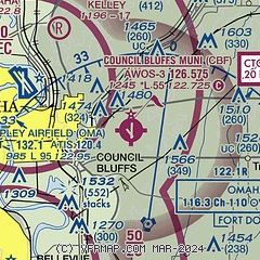
| Sectional chart |
|---|
|
CAUTION: Diagram may not be current

| Airport distance calculator |
|---|
|
|
| Sunrise and sunset |
|---|
|
Times for 14-Apr-2026
| | Local
(UTC-5) | | Zulu
(UTC) |
|---|
| Morning civil twilight | | 06:17 | | 11:17 |
| Sunrise | | 06:46 | | 11:46 |
| Sunset | | 20:01 | | 01:01 |
| Evening civil twilight | | 20:29 | | 01:29 |
|
| Current date and time |
|---|
| Zulu (UTC) | 14-Apr-2026 17:04:15 |
|---|
| Local (UTC-5) | 14-Apr-2026 12:04:15 |
|---|
|
| METAR |
|---|
| KCBF | 141655Z AUTO VRB04KT 10SM FEW020 FEW025 25/19 A2965 RMK AO2
|
KOMA
7nm NW | 141652Z 00000KT 10SM CLR 22/18 A2966 RMK AO2 SLP038 T02220178
|
KOFF
11nm SW | 141555Z 04004KT 10SM FEW022 FEW033 SCT130 22/17 A2965 RMK AO2A SLP038 T02210168
|
KMLE
16nm W | 141655Z AUTO 00000KT 10SM CLR 22/17 A2967 RMK AO2 T02200169
|
KBTA
18nm NW | 141655Z AUTO 05003KT 7SM SCT011 BKN032 BKN039 21/17 A2968 RMK AO2 T02110174
|
|
| TAF |
|---|
KOMA
7nm NW | 141623Z 1416/1512 36011KT P6SM FEW009 FM141800 14006KT P6SM FEW030 FM141900 24010G18KT P6SM FEW050 FM150000 36010KT P6SM SCT100 FM150500 06008KT P6SM BKN070
|
KOFF
11nm SW | 141000Z 1410/1516 14009KT 9999 FEW250 QNH2966INS BECMG 1415/1416 21012G18KT 9999 SCT150 QNH2961INS WND 24012G18KT AFT 1422 BECMG 1423/1424 34012G18KT 9999 BKN050 QNH2960INS BECMG 1501/1502 34012G18KT 9999 BKN025 QNH2965INS BECMG 1504/1505 VRB25G35KT 1600 -TSRAGR OVC005CB QNH2968INS BECMG 1509/1510 35010G15KT 4800 -RA OVC015 QNH2970INS TX27/1422Z TN16/1410Z
|
|
| NOTAMs |
|---|
NOTAMs are issued by the DoD/FAA and will open in a separate window not controlled by AirNav.
|
|


