FAA INFORMATION EFFECTIVE 30 OCTOBER 2025
Location
| FAA Identifier: | OFF |
| Lat/Long: | 41-07-09.5840N 095-54-30.6610W
41-07.159733N 095-54.511017W
41.1193289,-95.9085169
(estimated) |
| Elevation: | 1048.2 ft. / 319.5 m (surveyed) |
| Variation: | 02E (2020) |
| From city: | 8 miles SE of OMAHA, NE |
| Time zone: | UTC -6 (UTC -5 during Daylight Saving Time) |
| Zip code: | 68113 |
Airport Operations
| Airport use: | Private use. Permission required prior to landing |
| Activation date: | 05/1941 |
| Control tower: | yes |
| ARTCC: | MINNEAPOLIS CENTER |
| FSS: | COLUMBUS FLIGHT SERVICE STATION |
| NOTAMs facility: | OFF (NOTAM-D service available) |
| Attendance: | MON-FRI 0600-2200, ALL SAT-SUN 0700-1900 |
| Pattern altitude: | 3548.2 ft. MSL
TPA: VFR RECTANGULAR TFC PAT 2500 FT MSL, OVHD TFC PAT 3000 FT MSL, OVHD TFC RMN WI 5 NM. |
| Wind indicator: | yes |
| Segmented circle: | no |
| Beacon: | white-green (lighted land airport)
Operates sunset to sunrise. |
| International operations: | ACFT ARR FM FOREIGN AREAS CONFIRM ETA & CSTMS RQR
ONE HR PRIOR NTC THRU FSS. |
Airport Communications
| ATIS: | 126.025 273.5 |
| OFFUTT GROUND: | 121.7 289.4 |
| OFFUTT TOWER: | 123.7 279.625 |
| OMAHA APPROACH: | 124.5 ;EAST 135.875 ;WEST |
| OMAHA DEPARTURE: | 124.5 ;EAST 135.875 ;WEST |
| AANDY STAR: | 124.5 ;EAST 135.875 ;WEST |
| CLASS C: | 124.5 ;EAST 135.875 ;WEST |
| COMD POST: | 311.0 321.0 |
| EMERG: | 121.5 243.0 |
| GCA: | 290.55 340.9 378.8 |
| HOWRY STAR: | 124.5 ;EAST 135.875 ;WEST |
| IC: | 135.875 ;WEST |
| LANTK STAR: | 124.5 ;EAST 135.875 ;WEST |
| MARWI STAR: | 124.5 ;EAST 135.875 ;WEST |
| OPS: | 318.7 ;RAF OPS |
| PMSV METRO: | 227.4 |
| SFA: | 379.4 |
| TIMMO STAR: | 124.5 ;EAST 135.875 ;WEST |
| WX AWOS-3 at PMV (10 nm S): | 118.975 (402-298-7524) |
| WX AWOS-3 at MLE (10 nm NW): | 118.25 (402-895-6778) |
| WX AWOS-3 at CBF (11 nm NE): | 126.575 (712-323-1542) |
| WX ASOS at OMA (11 nm N): | PHONE 402-271-7515 |
| WX AWOS-3 at BTA (20 nm NW): | 120.225 (402-426-0448) |
- ALL RAF AIRCRAFT CONTACT RAF OPERATIONS; CALL SIGN PLAINSMAN; 30 MINUTES PRIOR TO ARRIVAL. PLAINSMAN OPERATES 24 HRS.
- FREQS 263.0 243.0 UNRELIABLE UP TO 12 MILES NW.
- REMARKS: CLASS C AIRSPACE 20 NM OUT ON SCTR FREQ.
- RMK: ATC WILL ENHANCE SFC OBSN WHEN TWR VIS GREATER THAN OR LESS THAN 4 SM, LESS THAN 4 SM AND DIFFERENT THAN RPT VIS, TORNADO, FUNNEL CLOUD, LIGHTNING OR THUNDERSTORMS OBSERVED.
- RMK: REMOTE BRIEFING SVC AVBL 15 OWS DSN 576-9755, C618-256-9755.
- A/G: REMARKS: SEE GLOBAL HF SYSTEMS LISTING IN FIH.
- REMARKS: AN/FMQ-19 FULLY OPR AND OPR IN AUTOMATED MODE. WX SENSOR ON RWY 31 SITED BLW GRADE OF RWY, OCNL CAUSING UNREPRESENTATIVE VIS MEASUREMENTS TO RPRT IN OBSN. OBSN PT OBST FR 360DEG-080DEG AND 130DEG-340DEG. SFC OBSN AUGMENTED WHEN ATC PERS CAN VIS SEE ENTIRE RY AND/OR WF PERS CAN VIS SEE END OF RY.
Nearby radio navigation aids
| VOR radial/distance | | VOR name | | Freq | | Var |
|---|
| OVRr242/8.3 | | OMAHA VORTAC | | 116.30 | | 08E |
| LNKr064/39.5 | | LINCOLN VORTAC | | 116.10 | | 09E |
| NDB name | | Hdg/Dist | | Freq | | Var | | ID |
|---|
| PLATTSMOUTH | | 356/10.5 | | 329 | | 05E | | PMV | .--. -- ...- |
| WAHOO | | 097/32.0 | | 400 | | 06E | | AHQ | .- .... --.- |
Airport Services
| Fuel available: | 100
100:F18 FUEL NOT FOR SALE TO PUBLIC. |
| Parking: | hangars |
| Airframe service: | MAJOR |
| Powerplant service: | MAJOR |
| Bottled oxygen: | LOW |
| Bulk oxygen: | LOW |
Runway Information
Runway 13/31
| Dimensions: | 11703 x 150 ft. / 3567 x 46 m |
| Surface: | asphalt/concrete/grooved, in good condition
SFC TYPE: PEM |
| Weight bearing capacity: | |
| Runway edge lights: | high intensity |
| RUNWAY 13 | | RUNWAY 31 |
| Latitude: | 41-07.767667N | | 41-06.551667N |
| Longitude: | 095-55.499667W | | 095-53.522667W |
| Elevation: | 1048.2 ft. | | 971.7 ft. |
| Traffic pattern: | left | | left |
| Runway heading: | 127 magnetic, 129 true | | 307 magnetic, 309 true |
| Displaced threshold: | 1008 ft. | | 1091 ft. |
| Declared distances: | LDA:10695 | | LDA:10612 |
| Markings: | precision, in good condition | | precision, in good condition |
| Visual slope indicator: | 4-light PAPI on right (3.00 degrees glide path) | | 4-light PAPI on left (2.80 degrees glide path) |
| RVR equipment: | touchdown, midfield, rollout | | touchdown, midfield, rollout |
| Approach lights: | ALSF1: standard 2,400 foot high intensity approach lighting system with centerline sequenced flashers (category I)
RWY 13 ALSF 1 NSTD : RWY 13 MISSING TWO LGT BARS DUE TO OFF BASE ROAD AND RR. | | ALSF1: standard 2,400 foot high intensity approach lighting system with centerline sequenced flashers (category I)
RWY 31 ALSF 1 NSTD : RWY 31 HAS AN ADDNL LGT BAR. |
| Runway end identifier lights: | yes | | yes |
| Touchdown point: | yes, lighted | | yes, lighted |
| Instrument approach: | LOC/GS | | ILS |
| Obstructions: | none | | rr, 450 ft. from runway, 18:1 slope to clear
50+-1 FROM DSPLCD THR. |
Airport Ownership and Management from official FAA records
| Ownership: | U.S. Air Force |
| Owner: | USAF
3902D AIR BASE WING/SAC/
OFFUTT AFB, OMAHA, NE 68113 |
| Manager: | CHIEF OF AFLD MANAGEMENT
3902D AIR BASE WING/SAC/
OFFUTT AFB, OMAHA, NE 68113
Phone 402-294-2793 |
Additional Remarks
| A30A-13 | FST 2025 FT CONC, NEXT 1742 FT TO TWY M HAS 75 FT WIDE CONC MID WITH ASPH EDGES. |
| A30A-31 | FST 2100 FT CONC, MID 5834 FT FM TWY M-TWY P ASPH. |
| - | JASU: (M32A-86) (AM32A-95). |
| - | FUEL: A++. |
| - | FLUID: W SP PRESAIR LHOX LOX. |
| - | OIL: O-148-156 SOAP. |
| - | TRAN ALERT: OPR MON-FRI 1130-0330Z++, SAT-SUN SBY FOR OFFL BUS ONLY. |
| - | CSTMS/AG/IMG: LCL ACFT COORD WITH CMD POST 2 HR PN DSN 271-325, MIL TRAN ACFT COORD WITH AMOPS 48 HR PN 1200Z++ MON-FRI AT DSN 271-3240. |
| - | PMSV METRO: FULL WX SVC AVBL H24 UNLESS SPECIFIED IN NOTAM. DSN 271-3459, C402-294-3459. REMOTE BRIEF AVBL VIA 15 OWS; DSN 576-9755, C618-256-9755. |
| - | RSTD: ALL ACFT MUST CMPLT 180 DEG TURN AT EOR OR TWY M AND P INT. ACFT WITH DV AND PAX CTC COMD POST AT LEAST 30 MIN PRIOR TO ETA AND WHEN 60 NM OUT. |
| - | CAUTION: GRADIENT FOR RWY 13 .7 % DOWN SLOPE; RWY 13 HAS HI EMBANKMENT APCH END TURB & HI VRBL CROSSWINDS DURING S TO SW SFC WINDS. NMRS LGT ACFT AT MILLARD ARPT ON APCH FOR RWY 13. |
| - | TFC PAT: ALL PATS ARE S OF RWY CNTRLN; |
| - | MISC: AFLD MGMT ISSUES NO COMSEC FOR TRANS CREWS. 55 WG COMD POST WILL PROVIDE TEMP STORAGE OF SECRET AND TOP SECRET. AM OPS DSN 271-3207/3240, C402-294-3207/3240, FAX DSN 272-4175, C402-232-4175. |
| - | RSTD: PPR, MIN 24 HR NTC RQR AND NO MORE THAN 14 DAYS PRIOR, CTC AM OPS. |
| - | CAUTION: ARRIVALS - RAILROAD/VEHICLE ROAD PENETRATE RWY 31 APCH LIGHT PLANE. |
| - | CSTMS/AG/IMG: LCL ACFT COORD WITH CMD POST 2 HR PN DSN 271-3725, MIL TRANS ACFT COORD WITH AMOPS 48 HR PN 1200-2100Z+ MON-FRI AT DSN 271-3240. |
| - | MISC: RQR ALT CK PT SIGN MISG FOR ARPT ELEV BEING 76 FT GTR THAN RWY 31 END ELEV. |
| - | MISC: RWY END 31 ELEV IS 973 FT, 76 FT BLW FLD ELEV. |
| - | MISC: BIRD HAZ POTENTIAL EXISTS. BIRD MIGRATION. |
| - | TRAN ALERT: EXP UP TO 2 HR FUEL DELAY FOR ALL TRAN ACFT. |
| - | CAUTION: MOWERS ADJ TO MOVEMENT AREA APR-OCT. |
| - | CAUTION: RWY COND CODE (RWY CC) NOT RPTD. |
| - | RSTD: DUE TO OBST, C5 AND 747-8 ACFT ARE NOT AUTHORIZED BYD VFR HOLD LINE ON NW HAMMERHEAD; ACFT MUST COMPLETE 180- TURN WITHIN 355 FT BTN RWY CNTRLN AND VFR HOLD POSN MRK. |
| - | USE CNTR 150 FT OF RWY 13/31, 75 FT EDGES NOT STRESSED FOR ACFT OVER 100,000 LBS. |
Instrument Procedures
NOTE: All procedures below are presented as PDF files. If you need a reader for these files, you should download the free Adobe Reader.NOT FOR NAVIGATION. Please procure official charts for flight.
FAA instrument procedures published for use from 30 October 2025 at 0901Z to 27 November 2025 at 0900Z.
STARs - Standard Terminal Arrivals |
|---|
| AANDY TWO (RNAV) | |
2 pages:
[1] [2] (286KB) |
| HOWRY THREE | |
download (220KB) |
| LANTK TWO | |
download (130KB) |
| MARWI FOUR | |
download (151KB) |
| TIMMO ONE (RNAV) | |
download (193KB) |
IAPs - Instrument Approach Procedures |
|---|
| HI-ILS OR LOC Z RWY 31 | |
download (162KB) |
| ILS OR LOC RWY 13 | |
download (149KB) |
| ILS OR LOC Y RWY 31 | |
download (160KB) |
| RNAV (GPS) RWY 13 | |
download (115KB) |
| RNAV (GPS) RWY 31 | |
download (105KB) |
| HI-TACAN Z RWY 13 | |
download (149KB) |
| HI-TACAN Z RWY 31 | |
download (140KB) |
| TACAN Y RWY 13 | |
download (150KB) |
| TACAN Y RWY 31 | |
download (140KB) |
| NOTE: Special Take-Off Minimums/Departure Procedures apply | |
download (355KB) |
Other nearby airports with instrument procedures:
KPMV - Plattsmouth Municipal Airport/Douglas V Duey Field (10 nm S)
KMLE - Millard Airport (10 nm NW)
KCBF - Council Bluffs Municipal Airport (11 nm NE)
KOMA - Eppley Airfield (11 nm N)
KBTA - Blair Executive Airport (20 nm NW)
|
|

Road maps at:
MapQuest
Bing
Google
| Aerial photo |
|---|
WARNING: Photo may not be current or correct
 Photo by Beau Linn
Photo taken 13-Oct-2012
from 2500' AGL looking northwest.
Photo by Beau Linn
Photo taken 13-Oct-2012
from 2500' AGL looking northwest.
Do you have a better or more recent aerial photo of Offutt Air Force Base that you would like to share? If so, please send us your photo.
|
| Sectional chart |
|---|
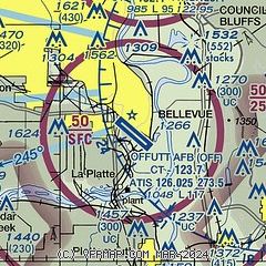
|
 Download PDF
of official airport diagram from the FAA
| Airport distance calculator |
|---|
|
|
| Sunrise and sunset |
|---|
|
Times for 25-Nov-2025
| | Local
(UTC-6) | | Zulu
(UTC) |
|---|
| Morning civil twilight | | 06:54 | | 12:54 |
| Sunrise | | 07:24 | | 13:24 |
| Sunset | | 16:57 | | 22:57 |
| Evening civil twilight | | 17:27 | | 23:27 |
|
| Current date and time |
|---|
| Zulu (UTC) | 26-Nov-2025 00:50:05 |
|---|
| Local (UTC-6) | 25-Nov-2025 18:50:05 |
|---|
|
| METAR |
|---|
| KOFF | 252355Z 31025G38KT 10SM BKN042 05/M05 A3005 RMK AO2A PK WND 31044/35 SLP185 T00451048 10099 20044 52035 $
|
KPMV
10nm S | 260030Z AUTO 31032G44KT 10SM SCT041 SCT047 SCT055 03/M04 A3007 RMK AO2 T00321045
|
KMLE
10nm NW | 260035Z AUTO 32019G31KT 7SM OVC036 03/M04 A3010 RMK AO2 T00341042
|
KCBF
11nm NE | 260035Z AUTO 31027G36KT 10SM BKN033 OVC039 03/M04 A3003 RMK AO2
|
KOMA
12nm N | 252352Z 31022G33KT 10SM OVC037 04/M03 A3004 RMK AO2 PK WND 30049/2317 SLP175 T00391033 10100 20039 51033
|
KBTA
20nm NW | 260035Z AUTO 30022G35KT 10SM OVC033 03/M04 A3007 RMK AO2 T00271041
|
|
| TAF |
|---|
| KOFF | 252115Z 2521/2701 31020G35KT 9999 BKN050 BKN250 510003 WSCONDS QNH2991INS BECMG 2606/2607 31015G25KT 9999 BKN040 510003 QNH3020INS TEMPO 2607/2609 31020G35KT BECMG 2608/2609 32010G18KT 9999 SCT030 QNH3028INS BECMG 2620/2621 33009KT 9999 SKC QNH3028INS TX08/2521Z TNM03/2613Z
|
KOMA
12nm N | 251723Z 2518/2618 31019G30KT P6SM SCT030 SCT250 FM252000 30022G42KT P6SM SCT050 FM260000 31024G40KT P6SM OVC026 FM260700 32021G31KT P6SM SCT030 FM261200 32016KT P6SM FEW210
|
|
| NOTAMs |
|---|
NOTAMs are issued by the DoD/FAA and will open in a separate window not controlled by AirNav.
|
|


