FAA INFORMATION EFFECTIVE 14 MAY 2026
Location
| FAA Identifier: | CGF |
| Lat/Long: | 41-33-52.5000N 081-29-14.0000W
41-33.875000N 081-29.233333W
41.5645833,-81.4872222
(estimated) |
| Elevation: | 876.1 ft. / 267.0 m (surveyed) |
| Variation: | 08W (1995) |
| From city: | 10 miles E of CLEVELAND, OH |
| Time zone: | UTC -4 (UTC -5 during Standard Time) |
| Zip code: | 44143 |
Airport Operations
| Airport use: | Open to the public |
| Activation date: | 06/1950 |
| Control tower: | yes |
| ARTCC: | CLEVELAND CENTER |
| FSS: | CLEVELAND FLIGHT SERVICE STATION |
| NOTAMs facility: | CGF (NOTAM-D service available) |
| Attendance: | 0600-2300
FOR AFT HRS SVC CALL 216-261-8800 DRG ATNDD HRS. |
| Wind indicator: | lighted |
| Segmented circle: | no |
| Lights: | WHEN ATCT CLSD ACTVT WINDSOCKS; MALSR RWY 24; REIL RWY 06; PAPI RWY 06; HIRL RWY 06/24 - CTAF. PAPI RWY 24 OPR CONSLY. |
| Beacon: | white-green (lighted land airport)
Operates sunset to sunrise. |
Airport Communications
| CTAF: | 118.5 |
| WX AWOS-3PT: | PHONE 216-998-7640 |
| COUNTY GROUND: | 121.85 [0700-2300] |
| COUNTY TOWER: | 118.5 [0700-2300] |
| CLEVELAND APPROACH: | 125.35 |
| CLEVELAND DEPARTURE: | 125.35 |
| CLEARANCE DELIVERY: | 121.85 ;WHEN TWR CLSD |
| BRWNZ STAR: | 126.55 |
| D-ATIS: | 119.95 |
| ROKNN STAR: | 126.55 |
| ROLLN STAR: | 126.55 |
| TRYBE STAR: | 126.55 |
| WX AWOS-3PT at LNN (8 nm NE): | 119.225 (440-942-0809) |
| WX ASOS at BKL (9 nm W): | PHONE 216-241-6904 |
| WX ASOS at CLE (19 nm SW): | PHONE 216-264-9022 |
- ATCT IS CONTRACTED.
- EMRG FREQ 121.5 UNMONITORED.
Nearby radio navigation aids
| VOR radial/distance | | VOR name | | Freq | | Var |
|---|
| ACOr339/30.3 | | AKRON VOR/DME | | 114.40 | | 04W |
| DJBr073/32.8 | | DRYER VOR/DME | | 113.60 | | 05W |
Airport Services
| Fuel available: | 100LL JET-A JET-A+ |
| Parking: | hangars and tiedowns |
| Airframe service: | MAJOR |
| Powerplant service: | MAJOR |
| Bottled oxygen: | HIGH |
| Bulk oxygen: | NONE |
Runway Information
Runway 6/24
| Dimensions: | 5502 x 100 ft. / 1677 x 30 m |
| Surface: | asphalt/grooved, in good condition |
| Weight bearing capacity: | | PCN 35 /F/C/X/U | | Single wheel: | 90.0 | | Double wheel: | 123.0 | | Double tandem: | 213.0 |
|
| Runway edge lights: | high intensity |
| RUNWAY 6 | | RUNWAY 24 |
| Latitude: | 41-33.579855N | | 41-34.168458N |
| Longitude: | 081-29.691603W | | 081-28.774553W |
| Elevation: | 876.1 ft. | | 874.0 ft. |
| Traffic pattern: | left | | left |
| Runway heading: | 057 magnetic, 049 true | | 237 magnetic, 229 true |
| Displaced threshold: | 318 ft. | | 500 ft. |
| Declared distances: | TORA:5502 TODA:5502 ASDA:5502 LDA:5184 | | TORA:5502 TODA:5502 ASDA:5502 LDA:5000 |
| Markings: | nonprecision, in good condition | | precision, in good condition |
| Visual slope indicator: | 4-light PAPI on left (3.00 degrees glide path) | | 4-light PAPI on left (3.00 degrees glide path) |
| Approach lights: | | | MALSR: 1,400 foot medium intensity approach lighting system with runway alignment indicator lights |
| Runway end identifier lights: | yes | | no |
| Touchdown point: | yes, no lights | | yes, no lights |
| Instrument approach: | | | ILS/DME |
| Obstructions: | 86 ft. tree, 1769 ft. from runway, 336 ft. right of centerline, 18:1 slope to clear
APCH SLP 24:1 TO DTHR 86 FT TREES, 2087 FT DIST, 336 FT R. | | 7 ft. road, 201 ft. from runway, 325 ft. left of centerline
7 FT ROAD, 0 FT DIST, 525 FT L; 2 FT FENCE, 0 FT DIST, 500 FT L. |
Airport Ownership and Management from official FAA records
| Ownership: | Publicly-owned |
| Owner: | CUYAHOGA COUNTY
26300 CURTISS WRIGHT PKWY
RICHMOND HEIGHTS, OH 44143-4408
Phone 216-289-4111 |
| Manager: | J MYERS
26300 CURTISS WRIGHT PKWY
RICHMOND HEIGHTS, OH 44143-4408
Phone 216-289-4111
CCAIRPORT@CUYAHOGACOUNTY.US. |
Additional Remarks
| - | NOISE ABATEMENT PROCS IN EFCT CALL ARPT. |
| - | FOR CD WHEN ATCT CLSD CTC CLEVELAND APCH AT 216-352-2323. |
| - | BIRDS & WILDLIFE ON & INVOF ARPT. |
| - | ATCT VIS SW LTD WI 500 FT AER 06. |
| - | FLT TRG PROHIBITED 2300-0700. |
Instrument Procedures
NOTE: All procedures below are presented as PDF files. If you need a reader for these files, you should download the free Adobe Reader.NOT FOR NAVIGATION. Please procure official charts for flight.
FAA instrument procedures published for use from 14 May 2026 at 0901Z to 11 June 2026 at 0900Z.
STARs - Standard Terminal Arrivals |
|---|
| BRWNZ FOUR (RNAV) **CHANGED** | |
2 pages:
[1] [2] (453KB) |
| BRWNZ FOUR (RNAV), CONT.2 | |
download (235KB) |
| ROKNN FOUR (RNAV) | |
2 pages:
[1] [2] (450KB) |
| ROLLN TWO (RNAV) **CHANGED** | |
download (347KB) |
| TRYBE FOUR (RNAV) **CHANGED** | |
2 pages:
[1] [2] (384KB) |
IAPs - Instrument Approach Procedures |
|---|
| ILS OR LOC RWY 24 | |
download (239KB) |
| RNAV (GPS) RWY 06 | |
download (218KB) |
| RNAV (GPS) RWY 24 | |
download (226KB) |
| NOTE: Special Alternate Minimums apply | |
download (150KB) |
Departure Procedures |
|---|
| AHMET FIVE (RNAV) | |
download (191KB) |
| CAVVS FIVE (RNAV) | |
download (178KB) |
| GTLKE FIVE (RNAV) | |
download (233KB) |
| MYCAR FIVE (RNAV) | |
download (174KB) |
| ZAAPA SIX (RNAV) | |
download (206KB) |
| NOTE: Special Take-Off Minimums/Departure Procedures apply | |
download (276KB) |
Other nearby airports with instrument procedures:
KLNN - Lake County Executive Airport (8 nm NE)
KBKL - Burke Lakefront Airport (9 nm W)
2G1 - Concord Airpark (14 nm NE)
KCLE - Cleveland-Hopkins International Airport (19 nm SW)
7G8 - Geauga County Airport (20 nm E)
|
|

Road maps at:
MapQuest
Bing
Google
| Aerial photo |
|---|
WARNING: Photo may not be current or correct

Do you have a better or more recent aerial photo of Cuyahoga County Airport that you would like to share? If so, please send us your photo.
|
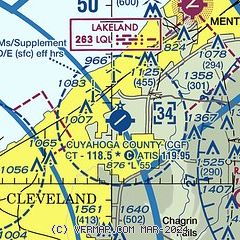
| Sectional chart |
|---|
|
CAUTION: Diagram may not be current
 Download PDF
of official airport diagram from the FAA
| Airport distance calculator |
|---|
|
|
| Sunrise and sunset |
|---|
|
Times for 05-Jun-2026
| | Local
(UTC-4) | | Zulu
(UTC) |
|---|
| Morning civil twilight | | 05:20 | | 09:20 |
| Sunrise | | 05:54 | | 09:54 |
| Sunset | | 20:55 | | 00:55 |
| Evening civil twilight | | 21:29 | | 01:29 |
|
| Current date and time |
|---|
| Zulu (UTC) | 05-Jun-2026 19:09:38 |
|---|
| Local (UTC-4) | 05-Jun-2026 15:09:38 |
|---|
|
| METAR |
|---|
| KCGF | 051845Z 23010G19KT 10SM SCT065 29/13 A2999
|
KLNN
8nm NE | 051855Z AUTO 25008KT 110V280 10SM SCT070 28/12 A2997 RMK AO1 T02760117
|
KBKL
8nm W | 051853Z 23016G22KT 10SM SCT070 30/13 A2996 RMK AO2 PK WND 23027/1807 SLP141 T03000133 $
|
KCLE
19nm SW | 051851Z 21020G25KT 10SM FEW065 SCT220 BKN250 29/13 A2997 RMK AO2 PK WND 25027/1753 SLP157 T02940133 $
|
|
| TAF |
|---|
KCLE
19nm SW | 051740Z 0518/0624 24012G22KT P6SM SCT060 FM060000 23010KT P6SM SCT070 BKN200 FM060700 22012G20KT P6SM VCSH BKN060 TEMPO 0608/0612 6SM -SHRA SCT025 BKN040 FM061700 24015G25KT P6SM VCSH BKN040 PROB30 0618/0621 3SM -TSRA OVC025CB
|
|
| NOTAMs |
|---|
NOTAMs are issued by the DoD/FAA and will open in a separate window not controlled by AirNav.
|
|


