FAA INFORMATION EFFECTIVE 19 MARCH 2026
Location
| FAA Identifier: | CGI |
| Lat/Long: | 37-13-31.1350N 089-34-14.7340W
37-13.518917N 089-34.245567W
37.2253153,-89.5707594
(estimated) |
| Elevation: | 341.5 ft. / 104.1 m (surveyed) |
| Variation: | 02W (2015) |
| From city: | 5 miles SW of CAPE GIRARDEAU, MO |
| Time zone: | UTC -5 (UTC -6 during Standard Time) |
| Zip code: | 63780 |
Airport Operations
| Airport use: | Open to the public |
| Activation date: | 04/1943 |
| Control tower: | yes |
| ARTCC: | MEMPHIS CENTER |
| FSS: | SAINT LOUIS FLIGHT SERVICE STATION |
| NOTAMs facility: | CGI (NOTAM-D service available) |
| Attendance: | MON-FRI 0600-1900, ALL SAT-SUN 0600-1800
FOR SVC AFT HRS CALL 573-335-6632. |
| Wind indicator: | lighted |
| Segmented circle: | no |
| Lights: | ACTVT MALSR RWY 10; ODALS RWY 28; HIRL RWY 10/28; MIRL RWY 02/20 - CTAF. |
| Beacon: | white-green (lighted land airport)
Operates sunset to sunrise. |
| Fire and rescue: | ARFF index A |
Airport Communications
| CTAF: | 125.525 |
| UNICOM: | 122.95 |
| WX ASOS: | 120.55 (573-335-3811) |
| CAPE GIRARDEAU GROUND: | 124.7 [0700-1900 MON-FRI; 0700-1700 SAT-SUN] |
| CAPE GIRARDEAU TOWER: | 125.525 [0700-1900 MON-FRI; 0700-1700 SAT-SUN] |
| WX AWOS-3 at CIR (19 nm SE): | 118.025 (618-734-9173) |
| WX AWOS-3 at SIK (20 nm S): | 119.175 (573-471-7371) |
- APCH/DEP SVC PRVDD BY MEMPHIS ARTCC ON FREQS 133.65/292.15 (PADUCAH RCAG).
Nearby radio navigation aids
| VOR radial/distance | | VOR name | | Freq | | Var |
|---|
| CNGr287/37.4 | | CUNNINGHAM VOR/DME | | 113.10 | | 03E |
| NDB name | | Hdg/Dist | | Freq | | Var | | ID |
|---|
| DUTCH | | 107/6.4 | | 248 | | 02W | | CG | -.-. --. |
Airport Services
| Fuel available: | 100LL JET-A |
| Parking: | hangars and tiedowns |
| Airframe service: | MAJOR |
| Powerplant service: | MAJOR |
| Bottled oxygen: | HIGH |
| Bulk oxygen: | NONE |
Runway Information
Runway 10/28
| Dimensions: | 6500 x 150 ft. / 1981 x 46 m |
| Surface: | concrete/grooved, in good condition |
| Weight bearing capacity: | | Single wheel: | 93.0 | | Double wheel: | 125.0 | | Double tandem: | 215.0 |
|
| Runway edge lights: | high intensity |
| RUNWAY 10 | | RUNWAY 28 |
| Latitude: | 37-13.642508N | | 37-13.350715N |
| Longitude: | 089-34.904917W | | 089-33.616140W |
| Elevation: | 336.9 ft. | | 340.6 ft. |
| Traffic pattern: | left | | left |
| Runway heading: | 108 magnetic, 106 true | | 288 magnetic, 286 true |
| Declared distances: | TORA:6500 TODA:6500 ASDA:6500 LDA:6500 | | TORA:6500 TODA:6500 ASDA:6500 LDA:6500 |
| Markings: | precision, in good condition | | nonprecision, in good condition |
| Visual slope indicator: | | | 2-box VASI on left (3.00 degrees glide path) |
| RVR equipment: | touchdown | | rollout |
| Approach lights: | MALSR: 1,400 foot medium intensity approach lighting system with runway alignment indicator lights | | ODALS: omnidirectional approach lighting system |
| Touchdown point: | yes, no lights | | yes, no lights |
| Instrument approach: | ILS/DME | | |
| Obstructions: | none | | 160 ft. tree, 5600 ft. from runway, 1100 ft. right of centerline, 33:1 slope to clear |
Runway 2/20
| Dimensions: | 3997 x 100 ft. / 1218 x 30 m |
| Surface: | asphalt/concrete, in fair condition |
| Weight bearing capacity: | | Single wheel: | 45.0 | | Double wheel: | 60.0 | | Double tandem: | 100.0 |
|
| Runway edge lights: | medium intensity |
| Operational restrictions: | RWY 02/20 NOT AVBL FOR PART 121/PART 380 OPS WITH SKED PAX CARRYING OPS MORE THAN 9 PAX SEATS AND NON-SKED PAX CARRYING OPS MORE THAN 30 PAX SEATS. |
| RUNWAY 2 | | RUNWAY 20 |
| Latitude: | 37-13.248113N | | 37-13.862160N |
| Longitude: | 089-34.370210W | | 089-34.072300W |
| Elevation: | 341.5 ft. | | 335.7 ft. |
| Traffic pattern: | left | | left |
| Runway heading: | 023 magnetic, 021 true | | 203 magnetic, 201 true |
| Declared distances: | TORA:3997 TODA:3997 ASDA:3997 LDA:3997 | | TORA:3997 TODA:3997 ASDA:3997 LDA:3997 |
| Markings: | nonprecision, in good condition | | nonprecision, in good condition |
| Visual slope indicator: | 4-box VASI on left (4.00 degrees glide path) | | 4-box VASI on left (3.00 degrees glide path) |
| Touchdown point: | yes, no lights | | yes, no lights |
| Obstructions: | 70 ft. tree, 1500 ft. from runway, 450 ft. left of centerline, 18:1 slope to clear | | none |
Airport Ownership and Management from official FAA records
| Ownership: | Publicly-owned |
| Owner: | CITY OF CAPE GIRARDEAU
CITY HALL, 401 INDEPENDENCE
CAPE GIRARDEAU, MO 63701
Phone 573-334-1212 |
| Manager: | JOJO STUART
PO BOX 617
CAPE GIRARDEAU, MO 63702
Phone 573-334-6230 |
Additional Remarks
| A39-02/20 | PCR VALUE: 185/R/D/W/T |
| A39-10/28 | PCR VALUE: 310/R/D/W/T |
| - | NORTHERN 100 FT TWY 'C' NOT VISIBLE FM CONTROL TOWER. |
| - | FOR CD CTC MEMPHIS ARTCC AT 901-368-8453/8449. |
| E110 | STANDBY GEN FOR FAA FAC ONLY |
Instrument Procedures
NOTE: All procedures below are presented as PDF files. If you need a reader for these files, you should download the free Adobe Reader.NOT FOR NAVIGATION. Please procure official charts for flight.
FAA instrument procedures published for use from 19 March 2026 at 0901Z to 16 April 2026 at 0900Z.
IAPs - Instrument Approach Procedures |
|---|
| ILS OR LOC RWY 10 | |
download (288KB) |
| RNAV (GPS) RWY 02 | |
download (270KB) |
| RNAV (GPS) RWY 10 | |
download (265KB) |
| RNAV (GPS) RWY 20 | |
download (253KB) |
| RNAV (GPS) RWY 28 | |
download (266KB) |
| LOC BC RWY 28 | |
download (275KB) |
| NOTE: Special Alternate Minimums apply | |
download (137KB) |
| NOTE: Special Take-Off Minimums/Departure Procedures apply | |
download (435KB) |
Other nearby airports with instrument procedures:
KCIR - Cairo Regional Airport (19 nm SE)
KSIK - Sikeston Memorial Municipal Airport (20 nm S)
KCHQ - Mississippi County Airport (25 nm SE)
KDXE - Dexter Municipal Airport (32 nm SW)
KMDH - Southern Illinois Airport (36 nm NE)
|
|

Road maps at:
MapQuest
Bing
Google
| Aerial photo |
|---|
WARNING: Photo may not be current or correct
 Photo by Danny Schnautz from a Mooney M20R w/ iPhone 6s
Photo taken 28-Apr-2018
looking southeast.
Photo by Danny Schnautz from a Mooney M20R w/ iPhone 6s
Photo taken 28-Apr-2018
looking southeast.
Do you have a better or more recent aerial photo of Cape Girardeau Regional Airport that you would like to share? If so, please send us your photo.
|
| Sectional chart |
|---|
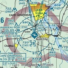
|
 Download PDF
of official airport diagram from the FAA
| Airport distance calculator |
|---|
|
|
| Sunrise and sunset |
|---|
|
Times for 30-Mar-2026
| | Local
(UTC-5) | | Zulu
(UTC) |
|---|
| Morning civil twilight | | 06:22 | | 11:22 |
| Sunrise | | 06:48 | | 11:48 |
| Sunset | | 19:18 | | 00:18 |
| Evening civil twilight | | 19:44 | | 00:44 |
|
| Current date and time |
|---|
| Zulu (UTC) | 30-Mar-2026 15:31:28 |
|---|
| Local (UTC-5) | 30-Mar-2026 10:31:28 |
|---|
|
| METAR |
|---|
| KCGI | 301522Z 20018G29KT 10SM BKN028 BKN049 22/16 A3014 RMK AO2 PK WND 19031/1457 T02170156
|
KCIR
19nm SE | 301515Z AUTO 22013G22KT 10SM BKN025 22/16 A3018 RMK AO2 T02190156
|
KSIK
20nm S | 301515Z AUTO 22015G21KT 10SM 22/16 A3016 RMK AO2 T02160162 $
|
|
| TAF |
|---|
| KCGI | 301120Z 3012/3112 20012G20KT P6SM BKN060 TEMPO 3012/3016 BKN020 FM301700 21020G30KT P6SM BKN035 FM310200 19013KT P6SM FEW250 FM310600 19011KT P6SM FEW250 WS020/22040KT
|
|
| NOTAMs |
|---|
NOTAMs are issued by the DoD/FAA and will open in a separate window not controlled by AirNav.
|
|


