FAA INFORMATION EFFECTIVE 09 JULY 2026
Location
| FAA Identifier: | CKF |
| Lat/Long: | 31-59-19.8400N 083-46-26.0600W
31-59.330667N 083-46.434333W
31.9888444,-83.7739056
(estimated) |
| Elevation: | 309.6 ft. / 94.4 m (surveyed) |
| Variation: | 06W (2020) |
| From city: | 2 miles NE of CORDELE, GA |
| Time zone: | UTC -4 (UTC -5 during Standard Time) |
| Zip code: | 31015 |
Airport Operations
| Airport use: | Open to the public |
| Activation date: | 03/1943 |
| Control tower: | no |
| ARTCC: | JACKSONVILLE CENTER |
| FSS: | MACON FLIGHT SERVICE STATION |
| NOTAMs facility: | MCN (NOTAM-D service available) |
| Attendance: | MON-FRI 0800-1700 |
| Wind indicator: | yes |
| Segmented circle: | yes |
| Lights: | MIRL RWY 10/28 & PAPI RWY 10 & 28 PRESET ON LOW INTST DUSK-2200; TO INCR INTST & ACTVT AFT 2200 - CTAF. ACTVT ODALS RWY 10 & REIL RWY 10 & 28 - CTAF. |
| Beacon: | white-green (lighted land airport)
Operates sunset to sunrise. |
Airport Communications
| CTAF/UNICOM: | 123.05 |
| WX AWOS-3PT: | 119.325 (229-276-2669) |
- APCH/DEP SVC PRVDD BY JACKSONVILLE ARTCC ON FREQS 125.75/363.075 (ALBANY RCAG).
Nearby radio navigation aids
| VOR radial/distance | | VOR name | | Freq | | Var |
|---|
| VNAr225/19.5 | | VIENNA VORTAC | | 116.50 | | 01E |
| PZDr055/33.2 | | PECAN VOR/DME | | 116.10 | | 02W |
| NDB name | | Hdg/Dist | | Freq | | Var | | ID |
|---|
| CONEY | | 103/4.5 | | 400 | | 06W | | OHY | --- .... -.-- |
| LINDBERGH | | 127/20.3 | | 242 | | 04W | | LKG | .-.. -.- --. |
| EASTMAN | | 259/32.7 | | 366 | | 04W | | EZM | . --.. -- |
| FITZGERALD | | 317/33.4 | | 362 | | 05W | | SUR | ... ..- .-. |
Airport Services
| Fuel available: | 100LL JET-A+ |
| Parking: | hangars and tiedowns |
| Airframe service: | MAJOR |
| Powerplant service: | MAJOR |
| Bottled oxygen: | NONE |
| Bulk oxygen: | NONE |
Runway Information
Runway 6/24
| Dimensions: | 5008 x 100 ft. / 1526 x 30 m |
| Surface: | asphalt, in fair condition |
| Weight bearing capacity: | |
| RUNWAY 6 | | RUNWAY 24 |
| Latitude: | 31-59.159512N | | 31-59.694110N |
| Longitude: | 083-46.836988W | | 083-46.098318W |
| Elevation: | 309.5 ft. | | 306.5 ft. |
| Traffic pattern: | left | | right |
| Runway heading: | 056 magnetic, 050 true | | 236 magnetic, 230 true |
| Displaced threshold: | 126 ft. | | 140 ft. |
| Markings: | nonprecision, in good condition | | nonprecision, in good condition |
| Touchdown point: | yes, no lights | | yes, no lights |
| Obstructions: | 27 ft. tree, 490 ft. from runway, 236 ft. right of centerline, 10:1 slope to clear | | 17 ft. trees, 414 ft. from runway, 271 ft. right of centerline, 12:1 slope to clear |
Runway 10/28
| Dimensions: | 5001 x 150 ft. / 1524 x 46 m |
| Surface: | asphalt, in good condition |
| Weight bearing capacity: | | Single wheel: | 30.0 | | Double wheel: | 45.0 |
|
| Runway edge lights: | medium intensity |
| RUNWAY 10 | | RUNWAY 28 |
| Latitude: | 31-59.288260N | | 31-59.180505N |
| Longitude: | 083-46.880677W | | 083-45.921208W |
| Elevation: | 301.4 ft. | | 308.3 ft. |
| Traffic pattern: | left | | right |
| Runway heading: | 104 magnetic, 098 true | | 284 magnetic, 278 true |
| Markings: | nonprecision, in good condition | | nonprecision, in good condition |
| Visual slope indicator: | 2-light PAPI on left (3.00 degrees glide path) | | 2-light PAPI on left (3.00 degrees glide path) |
| Approach lights: | ODALS: omnidirectional approach lighting system | | |
| Runway end identifier lights: | yes | | yes |
| Touchdown point: | yes, no lights | | yes, no lights |
| Instrument approach: | LOCALIZER | | |
| Obstructions: | 92 ft. trees, 2325 ft. from runway, 438 ft. right of centerline, 23:1 slope to clear | | 39 ft. trees, 600 ft. from runway, 278 ft. left of centerline, 10:1 slope to clear |
Airport Ownership and Management from official FAA records
| Ownership: | Publicly-owned |
| Owner: | CRISP COUNTY
210 7TH ST SOUTH
CORDELE, GA 31015
Phone 229-276-2672 |
| Manager: | SHERRIE LEVERETT
210 S 7TH STREET
CORDELE, GA 31015
Phone 229-276-2673 |
Additional Remarks
| - | FOR CD CTC JACKSONVILLE ARTCC AT 904-845-1592. |
Instrument Procedures
NOTE: All procedures below are presented as PDF files. If you need a reader for these files, you should download the free Adobe Reader.NOT FOR NAVIGATION. Please procure official charts for flight.
FAA instrument procedures published for use from 09 July 2026 at 0901Z to 06 August 2026 at 0900Z.
IAPs - Instrument Approach Procedures |
|---|
| RNAV (GPS) RWY 06 | |
download (223KB) |
| RNAV (GPS) RWY 10 | |
download (213KB) |
| RNAV (GPS) RWY 24 | |
download (218KB) |
| RNAV (GPS) RWY 28 | |
download (223KB) |
| LOC RWY 10 | |
download (249KB) |
| NOTE: Special Alternate Minimums apply | |
download (156KB) |
| NOTE: Special Take-Off Minimums/Departure Procedures apply | |
download (344KB) |
Other nearby airports with instrument procedures:
75J - Turner County Airport (19 nm S)
53A - Dr. C P Savage Sr. Airport (22 nm NW)
KACJ - Jimmy Carter Regional Airport (22 nm W)
KPXE - Perry-Houston County Airport (31 nm N)
KFZG - Fitzgerald Municipal Airport (31 nm SE)
|
|

Road maps at:
MapQuest
Bing
Google
| Aerial photo |
|---|
WARNING: Photo may not be current or correct
 Taken in October 2005
Do you have a better or more recent aerial photo of Crisp County-Cordele Airport that you would like to share? If so, please send us your photo.
|
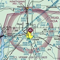
| Sectional chart |
|---|
|
| Airport distance calculator |
|---|
|
|
| Sunrise and sunset |
|---|
|
Times for 30-Jul-2026
| | Local
(UTC-4) | | Zulu
(UTC) |
|---|
| Morning civil twilight | | 06:23 | | 10:23 |
| Sunrise | | 06:50 | | 10:50 |
| Sunset | | 20:33 | | 00:33 |
| Evening civil twilight | | 21:00 | | 01:00 |
|
| Current date and time |
|---|
| Zulu (UTC) | 30-Jul-2026 04:54:55 |
|---|
| Local (UTC-4) | 30-Jul-2026 00:54:55 |
|---|
|
| METAR |
|---|
| KCKF | 300435Z AUTO 24003KT 10SM CLR 26/24 A2991 RMK AO2 T02620239
|
|
| TAF |
|---|
KABY
35nm SW | 291749Z 2918/3018 27008KT P6SM VCTS SCT040CB BKN060 OVC150 TEMPO 2918/2922 VRB20G30KT 3SM TSRA SCT025CB BKN040 OVC060 FM300300 26007KT P6SM SCT025 BKN150 FM301000 28003KT 5SM BR SCT004 FM301400 28005KT P6SM SCT025 SCT050
|
KWRB
39nm N | 300147Z 3001/3101 VRB06KT 9999 SKC QNH2982INS BECMG 3015/3016 30010G15KT 9999 FEW100 QNH2984INS BECMG 3100/3101 VRB06KT 9999 SKC QNH2989INS TX36/3019Z TN23/3011Z LAST NO AMDS AFT 3002 NEXT 3011
|
KMCN
42nm N | 300346Z 3004/3024 26004KT P6SM SKC FM300900 VRB03KT P6SM SKC FM301600 34005KT P6SM FEW040
|
|
| NOTAMs |
|---|
NOTAMs are issued by the DoD/FAA and will open in a separate window not controlled by AirNav.
|
|


