FAA INFORMATION EFFECTIVE 19 MARCH 2026
Location
| FAA Identifier: | WRB |
| Lat/Long: | 32-38-24.6150N 083-35-30.9150W
32-38.410250N 083-35.515250W
32.6401708,-83.5919208
(estimated) |
| Elevation: | 294.1 ft. / 90 m (estimated) |
| Variation: | 02W (1985) |
| From city: | 10 miles SE of WARNER ROBINS, GA |
| Time zone: | UTC -4 (UTC -5 during Standard Time) |
| Zip code: | 31098 |
Airport Operations
| Airport use: | Private use. Permission required prior to landing |
| Activation date: | 09/1943 |
| Control tower: | yes |
| ARTCC: | ATLANTA CENTER |
| FSS: | MACON FLIGHT SERVICE STATION |
| NOTAMs facility: | WRB (NOTAM-D service available) |
| Attendance: | MON-FRI 0500-2300, ALL SAT-SUN & HOLS 0600-2200 |
| Wind indicator: | yes |
| Segmented circle: | no |
| Beacon: | white-green (lighted land airport)
Operates sunset to sunrise. |
Airport Communications
| ATIS: | 119.475 273.475 |
| ROBINS GROUND: | 121.85 275.8 |
| ROBINS TOWER: | 133.225 257.975 |
| ATLANTA APPROACH: | 124.2 |
| ATLANTA ARTCC APPROACH: | 118.95 |
| ATLANTA DEPARTURE: | 124.2 |
| COMD POST: | 311.0 ;AFMC |
| MAINT CTL CENTER: | 225.925 |
| OPS: | 293.525 ;116 ANG OPS |
| PMSV METRO: | 349.85 |
| PTD: | 372.2 |
| WX ASOS at MCN (4 nm NW): | PHONE 478-795-1120 |
| WX AWOS-3 at PXE (12 nm SW): | 123.825 (478-987-8768) |
- ATLANTA TRACON PROVIDES APCH/DEP SVC 0615-2300 ON FREQS 124.2/279.6; ATLANTA ARTCC PROVIDES APCH/DEP SVC 2300-0615 ON FREQS 134.5/360.75 (MACON RCAG).
- ROBINS ALC-MAINT ACFT ONLY, NOT FOR RELAY OF SVC PAX CARGO PICKUP REQ. CALL EAGLE CONTROL 225.925.
- FULL SVC WX DURING AFLD OPR HRS MON-FRI, DSN 468-3573, C478-926-3573. STANDBY ON WKD AND HOL. BRIEFING SVC AVBL CTC C478-960-8471, MIN OF 3 HR PRIOR TO MSN/BRIEF REQ. AUTO FMQ-19 IN USE H24. AUGMENTED/BACKED UP FMQ-19 WHEN RQR. VIS RSTD S THRU WEST DUE TO OBST.
Nearby radio navigation aids
| VOR radial/distance | | VOR name | | Freq | | Var |
|---|
| VNAr348/26.0 | | VIENNA VORTAC | | 116.50 | | 01E |
| DBNr282/38.8 | | DUBLIN VORTAC | | 113.10 | | 05W |
| NDB name | | Hdg/Dist | | Freq | | Var | | ID |
|---|
| EASTMAN | | 328/37.7 | | 366 | | 04W | | EZM | . --.. -- |
| LINDBERGH | | 047/38.3 | | 242 | | 04W | | LKG | .-.. -.- --. |
Airport Services
| Fuel available: | A++ |
| Airframe service: | NONE |
| Powerplant service: | MAJOR |
| Bulk oxygen: | HIGH/LOW |
Runway Information
Runway 15/33
| Dimensions: | 12001 x 300 ft. / 3658 x 91 m |
| Surface: | PEM |
| Weight bearing capacity: | |
| Runway edge lights: | high intensity |
| RUNWAY 15 | | RUNWAY 33 |
| Latitude: | 32-39.211350N | | 32-37.609567N |
| Longitude: | 083-36.202533W | | 083-34.828983W |
| Elevation: | 292.6 ft. | | 272.7 ft. |
| Traffic pattern: | left | | right |
| Runway heading: | 146 magnetic, 144 true | | 326 magnetic, 324 true |
| Visual slope indicator: | 4-light PAPI on left (2.70 degrees glide path) | | 4-light PAPI on left (2.52 degrees glide path) |
| Approach lights: | ALSF1: standard 2,400 foot high intensity approach lighting system with centerline sequenced flashers (category I) | | ALSF1: standard 2,400 foot high intensity approach lighting system with centerline sequenced flashers (category I) |
| Touchdown point: | yes, no lights | | yes, no lights |
| Instrument approach: | ILS | | ILS |
Airport Ownership and Management from official FAA records
| Ownership: | U.S. Air Force |
| Owner: | USAF
ROBINS AFB
WARNER ROBINS, GA 31093 |
| Manager: | AIR FIELD MGR/653 RD OSS/OSA
ROBINS AFB;250 EAGLE ST
WARNER ROBINS, GA 31098-2602
Phone 478-926-2081 |
Additional Remarks
| E60-33 | BAK-14 BAK-12B(B) (1651') |
| E60-15 | BAK-14 BAK-12B(B) (1926') |
| - | FLUID: SP PRESAIR LHOX LOX LHNIT |
| - | OIL: O-148-156- SOAP - AVBL 1200-1900Z++WKD. |
| - | TRAN ALERT: OPR 1200-0300++ WKD, CLSD SAT, SUN AND HOL. AVBL WKEND FOR HHQ MSNS WITH 24 PN TO AMOPS. TRAN ACFT NOT ALLOWED WHEN TRAN ALERT UNAVBL. FLEET SVC NOT AVBL. DEICING UNAVBL. |
| - | CSTMS/AG/IMG: CSTMS, AG ON CALL WITH 2 HR PN RQR. US MIL PERS AND DEPENDENTS ONLY. |
| - | CAUTION: 3 LGT TV TWR 6.5 NM NE 1212 FT. |
| - | MISC: DEP ACFT DO NOT TURN ON TRANSPONDER TIL ENTERING RWY. ACFT WITH VIP CTC PTD 30 MIN PRIOR WITH FIRM BLOCK TIME. STD USAF RSRS APPLIED. |
| - | ANG: AMOPS OPR 1330-2130Z++ MON-FRI, EXC HOL, DSN 241-2313, C478-201-2313. |
| - | RSTD: PPR ALL ACFT, CTC AMOPS DSN 468-2114, C478-926-2114, FAX EXTN 7480. PPR ISSUED UP TO 72 HR PRIOR ARR AND WILL BE GOOD FOR +/- 1 HR. COORD OF PPR OUTSIDE OF BLOCK TIME BY FONE RQR OR WILL BE CONSIDERED CNL. |
| - | RADAR: SEE TERMINAL FLIP FOR RADAR MINIMA. |
| - | SERVICE- A-GEAR: BAK-12B- EXTN DISCONNECTED ON APCH END. |
| - | CAUTION: OBSN VIS RSTD SSW-NNW DUE TO OBST. DEPOT PARKING RAMP FLOODLIGHTS HAMPER NIGHT VIS. APCH END RWY 15 OBST BY BLDG AND ACFT PRK ON DEPOT PARKING RAMP. |
| - | CAUTION: ON APCH RWY 15, DO NOT MISTAKE MIDDLE GEORGIA RGNL ARPT 3.3 NM NW FOR ROBINS AFB. |
| - | AMOPS DOES NOT HAVE COMSEC AVBL FOR TRAN CREWS AND HAS NO STORAGE CAP. PRIOR ARNG MUST BE MADE WITH RCP FOR STORAGE OF CLASSIFIED. |
| - | AMOPS OPR 24 HR. |
| - | COMMUNICATIONS: AFRC COMD CTR - REMARKS: REQ FONE PATCH FR AFMC COMD POST TO (478) 327-0680. |
| - | RSTD: RWY 15/33 CLSD FOR PREVENTATIVE MAINTENANCE ON TUES AND THU FR 1000-1300Z++. |
| - | JASU: 2(A/M-60) 9(A/M323A-86) |
| - | CAUTION: BIRD WATCH COND-PHASE II FR NOV THRU MAR FR SR-30 TO SR+60 AND SS-30 TO SS+60; DATES ARE SUBJECT TO CHANGE WITH THE MIGRATORY SEASON. SEE NOTAMS FOR UPDATES. |
| - | NS ABTMT: STRICT ADHERENCE TO PROCEDURE, ACFT RSTD TO FULL STOP ONLY BETWEEN 0300-1100Z++. |
Instrument Procedures
NOTE: All procedures below are presented as PDF files. If you need a reader for these files, you should download the free Adobe Reader.NOT FOR NAVIGATION. Please procure official charts for flight.
FAA instrument procedures published for use from 19 March 2026 at 0901Z to 16 April 2026 at 0900Z.
Other nearby airports with instrument procedures:
KMCN - Middle Georgia Regional Airport (4 nm NW)
KMAC - Macon Downtown Airport (11 nm N)
KPXE - Perry-Houston County Airport (12 nm SW)
48A - Cochran Airport (21 nm SE)
53A - Dr. C P Savage Sr. Airport (29 nm SW)
|
|

Road maps at:
MapQuest
Bing
Google
| Aerial photo |
|---|
WARNING: Photo may not be current or correct
 Photo taken 07-May-2006
Do you have a better or more recent aerial photo of Robins Air Force Base that you would like to share? If so, please send us your photo.
|
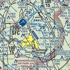
| Sectional chart |
|---|
|
 Download PDF
of official airport diagram from the FAA
| Airport distance calculator |
|---|
|
|
| Sunrise and sunset |
|---|
|
Times for 03-Apr-2026
| | Local
(UTC-4) | | Zulu
(UTC) |
|---|
| Morning civil twilight | | 06:56 | | 10:56 |
| Sunrise | | 07:21 | | 11:21 |
| Sunset | | 19:55 | | 23:55 |
| Evening civil twilight | | 20:19 | | 00:19 |
|
| Current date and time |
|---|
| Zulu (UTC) | 03-Apr-2026 18:48:07 |
|---|
| Local (UTC-4) | 03-Apr-2026 14:48:07 |
|---|
|
| METAR |
|---|
| KWRB | 031755Z AUTO 16005KT 10SM FEW038 28/16 A3024 RMK AO2 SLP240 60000 T02840163 10284 20159 57017 $
|
KMCN
4nm NW | 031753Z 20003KT 10SM FEW043 FEW050 FEW100 27/16 A3026 RMK AO2 SLP242 T02670161 10278 20133 58016
|
KPXE
12nm SW | 031835Z AUTO 10005KT 10SM SCT043 BKN060 BKN085 26/17 A3026 RMK AO2
|
|
| TAF |
|---|
| KWRB | 030200Z 0302/0408 VRB06KT 9999 FEW040 SCT090 QNH3017INS BECMG 0310/0311 VRB03KT 6000 BR BKN008 BKN015 QNH3025INS TEMPO 0311/0313 4800 BR BECMG 0314/0315 VRB06KT 9999 NSW BKN015 BKN030 QNH3027INS BECMG 0320/0321 13009KT 8000 -SHRA VCTS BKN030CB QNH3020INS TEMPO 0321/0324 13012G18KT 6000 -TSRA BKN020CB BECMG 0400/0401 13003KT 9999 NSW FEW007 BKN015 QNH3023INS BECMG 0406/0407 14003KT 8000 BR VCSH BKN007 QNH3019INS TX29/0320Z TN15/0311Z LAST NO AMDS AFT 0302 NEXT 0311
|
KMCN
4nm NW | 031720Z 0318/0418 15005KT P6SM BKN050 PROB30 0322/0401 4SM -TSRA OVC025CB FM040600 14003KT P6SM VCSH SCT025 OVC050 FM040900 00000KT P6SM BKN020 FM041100 00000KT 5SM BR BKN009 FM041400 16004KT P6SM BKN012
|
|
| NOTAMs |
|---|
NOTAMs are issued by the DoD/FAA and will open in a separate window not controlled by AirNav.
|
|


