FAA INFORMATION EFFECTIVE 02 OCTOBER 2025
Location
| FAA Identifier: | COE |
| Lat/Long: | 47-46-27.5000N 116-49-10.5000W
47-46.458333N 116-49.175000W
47.7743056,-116.8195833
(estimated) |
| Elevation: | 2320.3 ft. / 707.2 m (surveyed) |
| Variation: | 19E (1990) |
| From city: | 9 miles NW of COEUR D'ALENE, ID |
| Time zone: | UTC -7 (UTC -8 during Standard Time) |
| Zip code: | 83858 |
Airport Operations
| Airport use: | Open to the public |
| Activation date: | 12/1942 |
| Control tower: | no |
| ARTCC: | SEATTLE CENTER |
| FSS: | BOISE FLIGHT SERVICE STATION |
| NOTAMs facility: | COE (NOTAM-D service available) |
| Attendance: | 0700-1700 |
| Wind indicator: | lighted |
| Segmented circle: | yes |
| Lights: | ACTVT MIRL RY 02/20, HIRL RY 06/24, REIL RYS 02 & 24, & MALSR RY 06 - CTAF. PAPI RYS 02, 20, 06, & 24 OPER CONTINUOUSLY. |
| Beacon: | white-green (lighted land airport)
Operates sunset to sunrise. |
| Fire and rescue: | ARFF index A |
| Airline operations: | 48 HR PPR FOR UNSKED OPNS WITH MORE THAN 30 PSGR SEATS CALL AMGR 208-446-1860. |
| International operations: | US CUSTOMS USER FEE ARPT. |
Airport Communications
| CTAF/UNICOM: | 122.8 |
| WX AWOS-3PT: | 135.075 (208-772-8215) |
| SPOKANE APPROACH: | 132.1 |
| SPOKANE DEPARTURE: | 132.1 |
Nearby radio navigation aids
| VOR radial/distance | | VOR name | | Freq | | Var |
|---|
| COE at field | | COEUR D'ALENE VOR/DME | | 108.80 | | 19E |
| GEGr055/35.0 | | SPOKANE VORTAC | | 115.50 | | 14E |
| NDB name | | Hdg/Dist | | Freq | | Var | | ID |
|---|
| DEER PARK | | 099/27.0 | | 365 | | 16E | | DPY | -.. .--. -.-- |
| SANDPOE | | 184/32.6 | | 264 | | 14E | | SZT | ... --.. - |
Airport Services
| Fuel available: | 100 JET-A
100:AFT HRS FUEL. SELF SVC AVBL WITH CREDIT CARD. |
| Parking: | hangars and tiedowns |
| Airframe service: | MAJOR |
| Powerplant service: | MAJOR |
| Bottled oxygen: | HIGH/LOW |
| Bulk oxygen: | HIGH/LOW |
Runway Information
Runway 6/24
| Dimensions: | 7400 x 100 ft. / 2256 x 30 m |
| Surface: | asphalt/grooved, in good condition |
| Weight bearing capacity: | | Single wheel: | 57.0 | | Double wheel: | 95.0 | | Double tandem: | 165.0 |
|
| Runway edge lights: | high intensity |
| RUNWAY 6 | | RUNWAY 24 |
| Latitude: | 47-46.314572N | | 47-46.729612N |
| Longitude: | 116-50.224980W | | 116-48.527728W |
| Elevation: | 2277.4 ft. | | 2320.3 ft. |
| Traffic pattern: | left | | left |
| Runway heading: | 051 magnetic, 070 true | | 231 magnetic, 250 true |
| Declared distances: | TORA:7400 TODA:7400 ASDA:7400 LDA:7400 | | TORA:7400 TODA:7400 ASDA:7400 LDA:7400 |
| Markings: | precision, in good condition | | precision, in good condition |
| Visual slope indicator: | 4-light PAPI on right (3.00 degrees glide path) | | 4-light PAPI on right (3.00 degrees glide path) |
| Approach lights: | MALSR: 1,400 foot medium intensity approach lighting system with runway alignment indicator lights
RY 06 NSTD MALSR; THLD BAR EXTENDS 5 FT BYD RY EDGE LGTS EACH SIDE. | | |
| Runway end identifier lights: | | | yes |
| Touchdown point: | yes, no lights | | yes, no lights |
| Instrument approach: | ILS | | |
Runway 2/20
| Dimensions: | 5400 x 75 ft. / 1646 x 23 m |
| Surface: | asphalt/grooved, in good condition |
| Weight bearing capacity: | | Single wheel: | 50.0 | | Double wheel: | 83.0 | | Double tandem: | 150.0 |
|
| Runway edge lights: | medium intensity |
| RUNWAY 2 | | RUNWAY 20 |
| Latitude: | 47-45.996098N | | 47-46.746362N |
| Longitude: | 116-49.251938W | | 116-48.546922W |
| Elevation: | 2305.6 ft. | | 2319.0 ft. |
| Traffic pattern: | right | | left |
| Runway heading: | 013 magnetic, 032 true | | 193 magnetic, 212 true |
| Declared distances: | TORA:5400 TODA:5400 ASDA:5400 LDA:5400 | | TORA:5400 TODA:5400 ASDA:5400 LDA:5400 |
| Markings: | nonprecision, in good condition | | nonprecision, in good condition |
| Visual slope indicator: | 2-light PAPI on left (3.00 degrees glide path) | | 2-light PAPI on left (3.00 degrees glide path) |
| Runway end identifier lights: | yes | | |
| Touchdown point: | yes, no lights | | yes, no lights |
Airport Ownership and Management from official FAA records
| Ownership: | Publicly-owned |
| Owner: | KOOTENAI COUNTY
PO BOX 9000
COEUR D ALENE, ID 83816
Phone 208-446-1600 |
| Manager: | GASTON PATTERSON
10375 SENSOR AVE
HAYDEN, ID 83835
Phone 208-446-1860 |
Additional Remarks
| A39-06/24 | PCR VALUE: 470/F/A/X/T |
| A39-02/20 | PCR VALUE: 600/F/B/X/T |
| - | MIGRATORY BIRDS ON & INVOF ARPT OCT-NOV. |
| - | RWY: CONDS NOT MNTD 5 PM TO 7 AM DLY. |
| - | FOR CD IF UNA CTC ON 132.1 CTC SPOKANE APCH AT 509-742-2522. |
| - | PJE IN VCNTY. |
Instrument Procedures
NOTE: All procedures below are presented as PDF files. If you need a reader for these files, you should download the free Adobe Reader.NOT FOR NAVIGATION. Please procure official charts for flight.
FAA instrument procedures published for use from 02 October 2025 at 0901Z to 30 October 2025 at 0900z.
IAPs - Instrument Approach Procedures |
|---|
| ILS OR LOC RWY 06 **CHANGED** | |
download (389KB) |
| RNAV (GPS) RWY 02 **CHANGED** | |
download (293KB) |
| RNAV (GPS) RWY 06 **CHANGED** | |
download (346KB) |
| NOTE: Special Alternate Minimums apply | |
download (210KB) |
|
|---|
| COEUR DALENE TWO (OBSTACLE) | |
download (251KB) |
| NOTE: Special Take-Off Minimums/Departure Procedures apply | |
download (534KB) |
Other nearby airports with instrument procedures:
KSFF - Felts Field Airport (21 nm W)
KDEW - Deer Park Airport (27 nm NW)
KGEG - Spokane International Airport (30 nm W)
KSZT - Sandpoint Airport (33 nm N)
KSKA - Fairchild Air Force Base (35 nm W)
|
|

Road maps at:
MapQuest
Bing
Google
| Aerial photo |
|---|
WARNING: Photo may not be current or correct
 Photo by Carl Stearns
Photo taken 10-Oct-2018
looking southwest.
Photo by Carl Stearns
Photo taken 10-Oct-2018
looking southwest.
Do you have a better or more recent aerial photo of Coeur d'Alene Airport - Pappy Boyington Field that you would like to share? If so, please send us your photo.
|
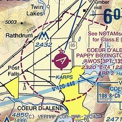
| Sectional chart |
|---|
|
CAUTION: Diagram may not be current

| Airport distance calculator |
|---|
|
|
| Sunrise and sunset |
|---|
|
Times for 22-Oct-2025
| | Local
(UTC-7) | | Zulu
(UTC) |
|---|
| Morning civil twilight | | 06:46 | | 13:46 |
| Sunrise | | 07:18 | | 14:18 |
| Sunset | | 17:46 | | 00:46 |
| Evening civil twilight | | 18:17 | | 01:17 |
|
| Current date and time |
|---|
| Zulu (UTC) | 23-Oct-2025 04:44:15 |
|---|
| Local (UTC-7) | 22-Oct-2025 21:44:15 |
|---|
|
| METAR |
|---|
| KCOE | 230356Z AUTO 25003KT 10SM 09/03 A3005 RMK AO2 SLP200 T00890028 $
|
|
| TAF |
|---|
| KCOE | 221739Z 2218/2318 04011KT P6SM SKC FM222100 04006KT P6SM FEW200 FM230100 VRB05KT P6SM SCT160 BKN200 FM231300 12005KT P6SM VCFG SCT150 FM231700 16007KT P6SM SCT120 BKN150
|
|
| NOTAMs |
|---|
NOTAMs are issued by the DoD/FAA and will open in a separate window not controlled by AirNav.
|
|


