FAA INFORMATION EFFECTIVE 22 JANUARY 2026
Location
| FAA Identifier: | CXO |
| Lat/Long: | 30-21-12.2239N 095-24-54.2950W
30-21.203732N 095-24.904917W
30.3533955,-95.4150819
(estimated) |
| Elevation: | 244.8 ft. / 74.6 m (surveyed) |
| Variation: | 05E (2000) |
| From city: | 37 miles N of HOUSTON, TX |
| Time zone: | UTC -6 (UTC -5 during Daylight Saving Time) |
| Zip code: | 77303 |
Airport Operations
| Airport use: | Open to the public |
| Activation date: | 05/1944 |
| Control tower: | yes |
| ARTCC: | HOUSTON CENTER |
| FSS: | MONTGOMERY COUNTY FLIGHT SERVICE STATION |
| NOTAMs facility: | CXO (NOTAM-D service available) |
| Attendance: | SAT-SUN 0800-1600, ALL MON-FRI 0800-1700 |
| Wind indicator: | lighted |
| Segmented circle: | yes |
| Lights: | HIRL RWY 14/32 PRESET LOW INTST; TO INCR INTST & ACTVT REIL RWY 32 - CTAF. |
| Beacon: | white-green (lighted land airport)
Operates sunset to sunrise. |
| International operations: | INTL ARPT U.S. CUST USER FEE ARPT. CALL U.S. CUST
936-441-7750. |
Airport Communications
| CTAF: | 124.125 |
| ATIS: | 118.325 |
| WX ASOS: | PHONE 936-760-4237 |
| CONROE GROUND: | 120.45 [0600-2100] |
| CONROE TOWER: | 124.125 [0600-2100] |
| HOUSTON APPROACH: | 119.7 |
| HOUSTON DEPARTURE: | 119.7 |
| CLEARANCE DELIVERY: | 120.45 119.55 ;WHEN TWR CLSD |
| ALEXANDRIA DP: | 119.7 |
| BLTWY RNAV DP: | 119.7 |
| BORRN RNAV DP: | 119.7 |
| CESAN STAR: | 121.3 |
| CRIED DP: | 119.7 |
| DREMR DP: | 119.7 |
| EL DORADO DP: | 119.7 |
| GIFFA DP: | 119.7 |
| HOODO RNAV DP: | 119.7 |
| HUDZY STAR: | 120.05 |
| INDIE RNAV DP: | 119.7 |
| JUNCTION DP: | 119.7 |
| KARRR RNAV DP: | 119.7 |
| LAKE CHARLES DP: | 119.7 |
| LEONA DP: | 119.7 |
| LUFKIN DP: | 119.7 |
| LURIC RNAV DP: | 119.7 |
| MMALT RNAV DP: | 119.7 |
| OHIIO STAR: | 120.05 |
| PIEGY RNAV STAR: | 119.7 |
| RIICE STAR: | 124.35 |
| STRYA DP: | 119.7 |
| STYCK DP: | 119.7 |
| WATFO DP: | 119.7 |
| WYLSN RNAV DP: | 119.7 |
| WX ASOS at DWH (19 nm S): | 128.375 (281-251-7853) |
Nearby radio navigation aids
| VOR radial/distance | | VOR name | | Freq | | Var |
|---|
| IAHr346/24.1 | | HUMBLE VORTAC | | 116.60 | | 05E |
| TNVr075/33.5 | | NAVASOTA VOR/DME | | 115.90 | | 08E |
| NDB name | | Hdg/Dist | | Freq | | Var | | ID |
|---|
| ALIBI | | 141/5.7 | | 281 | | 05E | | CX | -.-. -..- |
Airport Services
| Fuel available: | 100LL JET-A |
| Parking: | hangars and tiedowns |
| Airframe service: | MAJOR |
| Powerplant service: | MAJOR |
| Bottled oxygen: | HIGH/LOW |
| Bulk oxygen: | NONE |
Runway Information
Runway 14/32
| Dimensions: | 7501 x 150 ft. / 2286 x 46 m |
| Surface: | concrete, in good condition |
| Weight bearing capacity: | | PCN 36 /R/B/W/T | | Single wheel: | 60.0 | | Double wheel: | 100.0 |
|
| Runway edge lights: | high intensity |
| RUNWAY 14 | | RUNWAY 32 |
| Latitude: | 30-21.761953N | | 30-20.742333N |
| Longitude: | 095-25.226922W | | 095-24.418357W |
| Elevation: | 234.1 ft. | | 241.1 ft. |
| Traffic pattern: | left | | left |
| Runway heading: | 140 magnetic, 145 true | | 320 magnetic, 325 true |
| Markings: | precision, in good condition | | nonprecision, in good condition |
| Visual slope indicator: | 4-light PAPI on left (3.00 degrees glide path) | | 2-light PAPI on left (3.00 degrees glide path) |
| Approach lights: | MALSR: 1,400 foot medium intensity approach lighting system with runway alignment indicator lights | | |
| Runway end identifier lights: | | | yes |
| Touchdown point: | yes, no lights | | yes, no lights |
| Instrument approach: | ILS/DME | | |
| Obstructions: | 73 ft. trees, 2700 ft. from runway, 34:1 slope to clear | | none |
Runway 1/19
| Dimensions: | 5000 x 100 ft. / 1524 x 30 m |
| Surface: | concrete, in good condition |
| Weight bearing capacity: | | Single wheel: | 30.0 | | Double wheel: | 75.0 |
|
| Runway edge lights: | medium intensity |
| RUNWAY 1 | | RUNWAY 19 |
| Latitude: | 30-20.737110N | | 30-21.525098N |
| Longitude: | 095-25.168745W | | 095-24.887955W |
| Elevation: | 229.6 ft. | | 228.7 ft. |
| Traffic pattern: | left | | left |
| Runway heading: | 012 magnetic, 017 true | | 192 magnetic, 197 true |
| Declared distances: | TORA:5000 TODA:5000 ASDA:5000 LDA:5000 | | TORA:5000 TODA:5000 ASDA:5000 LDA:5000 |
| Markings: | nonprecision, in good condition | | nonprecision, in good condition |
| Visual slope indicator: | 2-light PAPI on left (3.15 degrees glide path) | | 2-light PAPI on left (3.00 degrees glide path) |
| Touchdown point: | yes, no lights | | yes, no lights |
| Obstructions: | 56 ft. trees, 1350 ft. from runway, 460 ft. both sides of centerline, 20:1 slope to clear | | 50 ft. trees, 1400 ft. from runway, 460 ft. both sides of centerline, 24:1 slope to clear |
Airport Ownership and Management from official FAA records
| Ownership: | Publicly-owned |
| Owner: | MONTGOMERY COUNTY
501 N. THOMPSON ST.
CONROE, TX 77301
Phone 936-539-7811 |
| Manager: | JAMES BROWN
10260 CARL PICKERING MEMORIAL
CONROE, TX 77303
Phone 936-788-8311 |
Additional Remarks
| A23 | HELS USE RIGHT-HAND TFC. |
| - | EXTSV MIL HEL ACTVY ON ARPT. |
| - | AVOID NOISE SENSITIVE AREA 10 MI SW QUAD OF ARPT. |
| - | MIL SVC FUEL 0600-2100 C936-494-4252. |
| - | FOR CD WHEN ATCT CLSD CTC HOUSTON APCH AT 281-443-5844, TO CNL IFR AT 281-443-5888. |
| - | EXTV STUDENT PILOT (SUNRISE TO SUNSET). |
Instrument Procedures
NOTE: All procedures below are presented as PDF files. If you need a reader for these files, you should download the free Adobe Reader.NOT FOR NAVIGATION. Please procure official charts for flight.
FAA instrument procedures published for use from 22 January 2026 at 0901Z to 19 February 2026 at 0900z.
STARs - Standard Terminal Arrivals |
|---|
| BAZBL ONE (RNAV) | |
download (255KB) |
| CESAN FOUR (RNAV) | |
2 pages:
[1] [2] (405KB) |
| HUDZY FIVE | |
2 pages:
[1] [2] (283KB) |
| OHIIO FOUR | |
download (266KB) |
| PIEGY ONE (RNAV) | |
download (135KB) |
| RIICE ONE | |
2 pages:
[1] [2] (506KB) |
IAPs - Instrument Approach Procedures |
|---|
| ILS OR LOC RWY 14 | |
download (269KB) |
| RNAV (GPS) RWY 01 | |
download (218KB) |
| RNAV (GPS) RWY 14 | |
download (217KB) |
| RNAV (GPS) RWY 19 | |
download (269KB) |
| RNAV (GPS) RWY 32 | |
download (215KB) |
| NDB RWY 14 | |
download (225KB) |
| NOTE: Special Alternate Minimums apply | |
download (148KB) |
Departure Procedures |
|---|
| ALEXANDRIA THREE | |
2 pages:
[1] [2] (320KB) |
| BLTWY SEVEN (RNAV) | |
download (187KB) |
| BORRN SIX (RNAV) | |
2 pages:
[1] [2] (336KB) |
| CRIED ONE | |
download (162KB) |
| EL DORADO ONE | |
download (174KB) |
| GIFFA ONE | |
download (160KB) |
| HOODO SEVEN (RNAV) | |
download (230KB) |
| INDIE EIGHT (RNAV) | |
download (213KB) |
| JUNCTION ONE | |
download (167KB) |
| KARRR SEVEN (RNAV) | |
2 pages:
[1] [2] (283KB) |
| LAKE CHARLES FIVE | |
download (167KB) |
| LEONA FOUR | |
2 pages:
[1] [2] (337KB) |
| LUFKIN FOUR | |
2 pages:
[1] [2] (248KB) |
| LURIC EIGHT (RNAV) | |
download (236KB) |
| MMALT SEVEN (RNAV) | |
download (241KB) |
| STRYA EIGHT (RNAV) | |
download (223KB) |
| STYCK EIGHT (RNAV) | |
download (212KB) |
| WATFO SIX (RNAV) | |
download (195KB) |
| WYLSN EIGHT (RNAV) | |
download (200KB) |
| NOTE: Special Take-Off Minimums/Departure Procedures apply | |
download (207KB) |
Other nearby airports with instrument procedures:
KDWH - David Wayne Hooks Memorial Airport (19 nm S)
6R3 - Cleveland Municipal Airport (21 nm E)
KIAH - George Bush Intercontinental/Houston Airport (22 nm S)
KUTS - Huntsville Municipal Airport (25 nm N)
00R - Livingston Municipal Airport (29 nm NE)
|
|

Road maps at:
MapQuest
Bing
Google
| Aerial photo |
|---|
WARNING: Photo may not be current or correct
 Photo by Galaxy FBO
Photo taken 08-Jan-2020
looking north-northwest.
Photo by Galaxy FBO
Photo taken 08-Jan-2020
looking north-northwest.
Do you have a better or more recent aerial photo of Conroe/North Houston Regional Airport that you would like to share? If so, please send us your photo.
|
| Sectional chart |
|---|
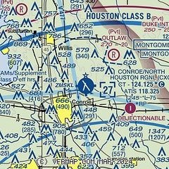
|
CAUTION: Diagram may not be current

| Airport distance calculator |
|---|
|
|
| Sunrise and sunset |
|---|
|
Times for 11-Feb-2026
| | Local
(UTC-6) | | Zulu
(UTC) |
|---|
| Morning civil twilight | | 06:42 | | 12:42 |
| Sunrise | | 07:06 | | 13:06 |
| Sunset | | 18:06 | | 00:06 |
| Evening civil twilight | | 18:30 | | 00:30 |
|
| Current date and time |
|---|
| Zulu (UTC) | 11-Feb-2026 13:12:42 |
|---|
| Local (UTC-6) | 11-Feb-2026 07:12:42 |
|---|
|
| METAR |
|---|
| KCXO | 111253Z 00000KT 4SM -RA BR OVC006 16/16 A3017 RMK AO2 RAB32 SLP213 P0001 T01610161
|
KDWH
19nm S | 111302Z 24003KT 3/4SM BR SCT031 OVC090 16/16 A3016 RMK AO2 T01610161
|
|
| TAF |
|---|
| KCXO | 111121Z 1112/1212 VRB05KT 4SM BR VCSH SCT025 BKN035 PROB30 1112/1114 1 1/2SM -RA BR BKN025 FM111500 33005KT P6SM SCT012 SCT025 BKN035 FM112000 32005KT P6SM SCT040 SCT250 FM120900 36002KT P6SM FEW020 SCT250
|
|
| NOTAMs |
|---|
NOTAMs are issued by the DoD/FAA and will open in a separate window not controlled by AirNav.
|
|


