FAA INFORMATION EFFECTIVE 14 MAY 2026
Location
| FAA Identifier: | DWH |
| Lat/Long: | 30-03-42.4048N 095-33-10.0383W
30-03.706747N 095-33.167305W
30.0617791,-95.5527884
(estimated) |
| Elevation: | 152.4 ft. / 46.5 m (surveyed) |
| Variation: | 05E (2000) |
| From city: | 17 miles NW of HOUSTON, TX |
| Time zone: | UTC -5 (UTC -6 during Standard Time) |
| Zip code: | 77379 |
Airport Operations
| Airport use: | Open to the public |
| Activation date: | 09/1963 |
| Control tower: | yes |
| ARTCC: | HOUSTON CENTER |
| FSS: | MONTGOMERY COUNTY FLIGHT SERVICE STATION |
| NOTAMs facility: | DWH (NOTAM-D service available) |
| Attendance: | CONTINUOUS |
| Wind indicator: | lighted |
| Segmented circle: | yes |
| Lights: | WHEN ATCT CLSD ACTVT REIL RWYS 17R & 35L; HIRL RWY 17R/35L - CTAF. |
| Beacon: | white-green (lighted land airport)
Operates sunset to sunrise. |
Airport Communications
| CTAF: | 118.4 |
| UNICOM: | 122.95 |
| ATIS: | 128.375 |
| WX ASOS: | 128.375 (281-251-7853) |
| HOOKS GROUND: | 121.8 239.0 [0700-2200] |
| HOOKS TOWER: | 118.4 ;WEST 127.4 ;EAST 354.1 [0700-2200] |
| HOUSTON APPROACH: | 119.7 |
| HOUSTON DEPARTURE: | 119.7 |
| CLEARANCE DELIVERY: | 119.45 |
| ALEXANDRIA DP: | 119.7 |
| BLTWY RNAV DP: | 119.7 |
| BORRN RNAV DP: | 119.7 ;RWY 35L, 35R 123.8 ;RWY 17L, 17R |
| CRIED DP: | 119.7 |
| DREMR DP: | 119.7 |
| EL DORADO DP: | 119.7 |
| GIFFA DP: | 119.7 |
| HOODO RNAV DP: | 119.7 ;RWY 35L, 35R 123.8 ;RWY 17L, 17R |
| HUDZY STAR: | 120.05 |
| INDIE RNAV DP: | 119.7 ;RWY 35L, 35R 123.8 ;RWY 17L, 17R |
| JUNCTION DP: | 119.7 ;RWY 35L, 35R 123.8 ;RWY 17L, 17R |
| KARRR RNAV DP: | 119.7 ;RWY 35L, 35R 123.8 ;RWY 17L, 17R |
| LAKE CHARLES DP: | 119.7 |
| LEONA DP: | 119.7 |
| LUFKIN DP: | 119.7 |
| LURIC RNAV DP: | 119.7 |
| MMALT RNAV DP: | 119.7 |
| OHIIO STAR: | 120.05 |
| PIEGY RNAV STAR: | 119.7 |
| RIICE STAR: | 124.35 |
| STRYA DP: | 119.7 |
| STYCK DP: | 119.7 |
| TRUAX DP: | 119.7 |
| WATFO DP: | 119.7 ;RWY 35L, 35R 123.8 ;RWY 17L, 17R |
| WYLSN RNAV DP: | 119.7 ;RWY 35L, 35R 123.8 ;RWY 17L, 17R |
| WX ASOS at IAH (12 nm SE): | PHONE 713-338-9561 |
| WX ASOS at CXO (19 nm N): | PHONE 936-379-2019 |
- GND CTL FREQ 348.6 OTS INDEFLY.
Nearby radio navigation aids
| VOR radial/distance | | VOR name | | Freq | | Var |
|---|
| IAHr295/12.5 | | HUMBLE VORTAC | | 116.60 | | 05E |
| TNVr109/29.5 | | NAVASOTA VOR/DME | | 115.90 | | 08E |
Airport Services
| Fuel available: | 100LL JET-A1+ |
| Parking: | hangars and tiedowns |
| Airframe service: | MAJOR |
| Powerplant service: | MAJOR |
| Bulk oxygen: | LOW |
Runway Information
Runway 17R/35L
| Dimensions: | 7009 x 100 ft. / 2136 x 30 m |
| Surface: | asphalt, in good condition |
| Weight bearing capacity: | | Single wheel: | 30.0 | | Double wheel: | 85.0 |
|
| Runway edge lights: | high intensity |
| RUNWAY 17R | | RUNWAY 35L |
| Latitude: | 30-04.398802N | | 30-03.251697N |
| Longitude: | 095-33.288798W | | 095-33.121113W |
| Elevation: | 150.5 ft. | | 145.3 ft. |
| Traffic pattern: | left | | left |
| Runway heading: | 168 magnetic, 173 true | | 348 magnetic, 353 true |
| Displaced threshold: | 1007 ft. | | no |
| Declared distances: | TORA:7009 TODA:7009 ASDA:7009 LDA:6002 | | TORA:6700 TODA:6700 ASDA:6700 LDA:6700 |
| Markings: | nonprecision, in good condition | | nonprecision, in good condition |
| Visual slope indicator: | 4-light PAPI on right (3.00 degrees glide path) | | 4-light PAPI on left (3.00 degrees glide path) |
| Runway end identifier lights: | yes
REIL LCTD 126 FT BYD DSPLCD THR. | | yes |
| Touchdown point: | yes, no lights | | yes, no lights |
| Instrument approach: | LOC/DME | | |
| Obstructions: | 15 ft. road, 200 ft. from runway, 160 ft. left of centerline
8 FT FENCE, 0 FT DSTC, 240 L, 15 FT RD, 145 FT DSTC, 238 FT L. | | 60 ft. trees, 300 ft. from runway, 260 ft. left of centerline, 1:1 slope to clear |
Runway 17L/35R
| Dimensions: | 3500 x 35 ft. / 1067 x 11 m |
| Surface: | asphalt, in good condition |
| Weight bearing capacity: | |
| RUNWAY 17L | | RUNWAY 35R |
| Latitude: | 30-03.755833N | | 30-03.183042N |
| Longitude: | 095-33.133167W | | 095-33.050648W |
| Elevation: | 149.9 ft. | | 143.7 ft. |
| Traffic pattern: | left | | right |
| Runway heading: | 168 magnetic, 173 true | | 348 magnetic, 353 true |
| Displaced threshold: | no | | 208 ft. |
| Markings: | basic, in good condition | | basic, in good condition |
| Touchdown point: | yes, no lights | | yes, no lights |
| Obstructions: | none | | 60 ft. trees, lighted, 300 ft. from runway, 110 ft. left of centerline, 1:1 slope to clear
OBSTN CLNC SLOPE 7:1 AT DSPLCD THLD. |
Helipad H1
| Dimensions: | 50 x 50 ft. / 15 x 15 m |
| Surface: | asphalt, in fair condition |
| Latitude: | 30-04.134000N | | |
| Longitude: | 095-33.111167W | | |
| Elevation: | 147.0 ft. | | |
| Traffic pattern: | left | | left |
| Markings: | basic, in fair condition | | |
Helipad H2
| Dimensions: | 50 x 50 ft. / 15 x 15 m |
| Surface: | asphalt, in fair condition |
| Latitude: | 30-04.116333N | | |
| Longitude: | 095-33.111167W | | |
| Elevation: | 148.0 ft. | | |
| Traffic pattern: | left | | left |
| Markings: | basic, in fair condition | | |
Helipad H3
| Dimensions: | 50 x 50 ft. / 15 x 15 m |
| Surface: | asphalt, in fair condition |
| Latitude: | 30-04.098500N | | |
| Longitude: | 095-33.111167W | | |
| Elevation: | 148.0 ft. | | |
| Traffic pattern: | left | | left |
| Markings: | basic, in fair condition | | |
Helipad H4
| Dimensions: | 50 x 50 ft. / 15 x 15 m |
| Surface: | asphalt, in fair condition |
| Latitude: | 30-04.080667N | | |
| Longitude: | 095-33.111167W | | |
| Elevation: | 148.0 ft. | | |
| Traffic pattern: | left | | left |
| Markings: | basic, in fair condition | | |
Runway 17W/35W
| Dimensions: | 2530 x 100 ft. / 771 x 30 m |
| Surface: | water, in good condition |
| Runway edge markings: | BUOY |
| RUNWAY 17W | | RUNWAY 35W |
| Latitude: | 30-03.862833N | | 30-03.445500N |
| Longitude: | 095-33.066500W | | 095-33.064333W |
| Elevation: | 138.0 ft. | | 138.0 ft. |
| Traffic pattern: | left | | right |
| Markings: | none, in good condition | | none, in good condition |
| Touchdown point: | yes, no lights | | yes, no lights |
| Obstructions: | 10 ft. berm
ALSO 25 FT HGRS, 185 FT DSTC, 135 FT L, 7:1. | | 4 ft. berm |
Airport Ownership and Management from official FAA records
| Ownership: | Privately-owned |
| Owner: | JAG GILL
20803 STEUBNER AIRLINE, NR 0
SPRING, TX 77379
Phone 281-376-5436
NORTHWEST ARPT MANAGEMENT, L.P. |
| Manager: | AMY MOUNGER
20803 STEUBNER AIRLINE, NR 0
SPRING, TX 77379
Phone 281-376-5436
RSCHMIDT@HOOKSAIRPORT.COM |
Additional Remarks
| - | TWYS UNLGTD. |
| - | TWYS A & B CLSD EAST OF RWY 17R. |
| - | NOISE SENSITIVE AREA SW OF ARPT. ALL MIL ACFT DEPARTING RWY 17R CLIMB RWY HDG TO 650 FT MSL PRIOR TO TURNS OR REJOIN. |
| - | ACFT 25000 LBS & OVR ARE RSTRD TO TWYS C, P, E (BTN TWYS P & G), TWY G (NORTH OF TWY E), RAMPS A AND C AND THE TOMBALL JET CNTR RAMP. ALL OTHER TWYS RSTRD TO ACFT BLW 25000 LBS. |
| - | TWYS D & K RSTRD TO ACFT 12500 LBS AND BLW. |
| - | INT WHERE TWYS PAPA, ECHO, JULIETTE & KILO MEET IS REFERRED TO AS THE TRIANGLE. |
| - | FOR CD WHEN ATCT CLSD, CTC HOUSTON APCH ON CD FREQ OR CALL 281-443-5844. FOR IFR CANCELLATION WHEN ATCT CLSD, CALL 281-443-5888. |
| - | WILDLIFE ON & INVOF ARPT. |
| - | RAPID RFL AVBL HEL DURG FBO HRS, PPR 24 HRS. CTC OPNS MGR 832-953-8572 OR FREQ 122.95 PRIOR TO LNDG. |
| - | AFT SS LRG ACFT USE TWY P BTN TWYS E & C. |
| - | HEL PRACTICE AREA WEST OF ATCT AT OR BLW 600 FT. |
| - | FOUR HEL PRKG PADS LCTD EAST OF TWY K. |
| - | TWY K RSTRD TO PISTON ACFT ONLY. |
Instrument Procedures
NOTE: All procedures below are presented as PDF files. If you need a reader for these files, you should download the free Adobe Reader.NOT FOR NAVIGATION. Please procure official charts for flight.
FAA instrument procedures published for use from 14 May 2026 at 0901Z to 11 June 2026 at 0900Z.
STARs - Standard Terminal Arrivals |
|---|
| BAZBL ONE (RNAV) | |
download (256KB) |
| HUDZY FIVE | |
2 pages:
[1] [2] (284KB) |
| OHIIO FOUR | |
download (266KB) |
| PIEGY ONE (RNAV) | |
download (135KB) |
| RIICE ONE | |
2 pages:
[1] [2] (507KB) |
IAPs - Instrument Approach Procedures |
|---|
| RNAV (GPS) RWY 17R | |
download (277KB) |
| RNAV (GPS) RWY 35L | |
download (248KB) |
| LOC RWY 17R | |
download (245KB) |
| NOTE: Special Alternate Minimums apply | |
download (134KB) |
Departure Procedures |
|---|
| ALEXANDRIA THREE | |
2 pages:
[1] [2] (318KB) |
| BLTWY SEVEN (RNAV) | |
download (169KB) |
| BORRN SIX (RNAV) | |
2 pages:
[1] [2] (320KB) |
| CRIED ONE | |
download (165KB) |
| EL DORADO ONE | |
download (178KB) |
| GIFFA ONE | |
download (164KB) |
| HOODO SEVEN (RNAV) | |
download (214KB) |
| INDIE EIGHT (RNAV) | |
download (197KB) |
| JUNCTION ONE | |
download (175KB) |
| KARRR SEVEN (RNAV) | |
2 pages:
[1] [2] (267KB) |
| LAKE CHARLES FIVE | |
download (170KB) |
| LEONA FOUR | |
2 pages:
[1] [2] (336KB) |
| LUFKIN FOUR | |
2 pages:
[1] [2] (248KB) |
| LURIC EIGHT (RNAV) | |
download (218KB) |
| MMALT SEVEN (RNAV) | |
download (224KB) |
| STRYA EIGHT (RNAV) | |
download (207KB) |
| STYCK EIGHT (RNAV) | |
download (194KB) |
| WATFO SIX (RNAV) | |
download (181KB) |
| WYLSN EIGHT (RNAV) | |
download (185KB) |
| NOTE: Special Take-Off Minimums/Departure Procedures apply | |
download (210KB) |
Other nearby airports with instrument procedures:
KIAH - George Bush Intercontinental/Houston Airport (12 nm SE)
KIWS - West Houston Airport (16 nm SW)
KCXO - Conroe/North Houston Regional Airport (19 nm N)
KTME - Houston Executive Airport (24 nm SW)
KSGR - Sugar Land Regional Airport (27 nm S)
|
|

Road maps at:
MapQuest
Bing
Google
| Aerial photo |
|---|
WARNING: Photo may not be current or correct
 Photo courtesy of AirNav, LLC
Photo taken 30-Sep-2014
looking south.
Photo courtesy of AirNav, LLC
Photo taken 30-Sep-2014
looking south.
Do you have a better or more recent aerial photo of David Wayne Hooks Memorial Airport that you would like to share? If so, please send us your photo.
|
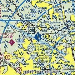
| Sectional chart |
|---|
|
CAUTION: Diagram may not be current
 Download PDF
of official airport diagram from the FAA
| Airport distance calculator |
|---|
|
|
| Sunrise and sunset |
|---|
|
Times for 26-May-2026
| | Local
(UTC-5) | | Zulu
(UTC) |
|---|
| Morning civil twilight | | 05:57 | | 10:57 |
| Sunrise | | 06:24 | | 11:24 |
| Sunset | | 20:14 | | 01:14 |
| Evening civil twilight | | 20:41 | | 01:41 |
|
| Current date and time |
|---|
| Zulu (UTC) | 26-May-2026 18:19:18 |
|---|
| Local (UTC-5) | 26-May-2026 13:19:18 |
|---|
|
| METAR |
|---|
| KDWH | 261753Z 12005KT 10SM FEW039 SCT050 BKN060 31/21 A2989 RMK AO2 SLP119 T03060206 10306 20211 58012
|
KIAH
10nm E | 261753Z 13008KT 10SM SCT035 SCT150 BKN250 29/22 A2989 RMK AO2 SLP119 CB DSIPTD T02940217 10300 20222 58010
|
KCXO
19nm N | 261753Z 13007KT 10SM FEW043 30/21 A2990 RMK AO2 SLP120 T03000211 10306 20206 58011
|
|
| TAF |
|---|
KIAH
10nm E | 261735Z 2618/2724 14009KT P6SM VCSH SCT025 BKN250 FM262200 14012KT P6SM SCT040 BKN250 FM270000 13010KT P6SM OVC250 FM270700 18010KT 5SM -SHRA BR VCTS BKN025CB TEMPO 2708/2712 VRB20G30KT 3SM +TSRA BR BKN015CB FM271400 22007KT 4SM -RA BR VCTS BKN015CB FM271800 08008KT P6SM VCSH BKN040
|
KCXO
19nm N | 261735Z 2618/2718 14005KT P6SM VCSH SCT035 BKN250 FM262200 14008KT P6SM SCT040 BKN250 FM270700 18010KT 5SM -SHRA BR VCTS BKN025CB TEMPO 2707/2711 VRB20G30KT 3SM +TSRA BR BKN015CB FM271400 18007KT 4SM -RA BR VCTS BKN015CB
|
|
| NOTAMs |
|---|
NOTAMs are issued by the DoD/FAA and will open in a separate window not controlled by AirNav.
|
|


