FAA INFORMATION EFFECTIVE 30 OCTOBER 2025
Location
| FAA Identifier: | EKN |
| Lat/Long: | 38-53-22.0000N 079-51-25.7000W
38-53.366667N 079-51.428333W
38.8894444,-79.8571389
(estimated) |
| Elevation: | 1987.2 ft. / 605.7 m (surveyed) |
| Variation: | 07W (1985) |
| From city: | 2 miles S of ELKINS, WV |
| Time zone: | UTC -5 (UTC -4 during Daylight Saving Time) |
| Zip code: | 26241 |
Airport Operations
| Airport use: | Open to the public |
| Activation date: | 06/1938 |
| Control tower: | no |
| ARTCC: | CLEVELAND CENTER |
| FSS: | ELKINS FLIGHT SERVICE STATION [703-724-4288] |
| NOTAMs facility: | EKN (NOTAM-D service available) |
| Attendance: | 0830-1700 |
| Pattern altitude: | 3000.2 ft. MSL |
| Wind indicator: | lighted |
| Segmented circle: | no |
| Lights: | ACTVT MIRL RWY 05/23 & REIL RWY 23 - 122.9. |
| Beacon: | white-green (lighted land airport)
Operates sunset to sunrise. |
Airport Communications
| CTAF: | 123.6 |
| WX ASOS: | 119.275 (304-636-5603) |
| CLARKSBURG APPROACH: | 121.15 [0700-2300] |
| CLARKSBURG DEPARTURE: | 121.15 [0700-2300] |
- APCH/DEP SVC PRVDD BY WASHINGTON ARTCC ON FREQS 128.6/226.675 (ELKINS RCAG) WHEN CLARKSBURG APCH CTL CLSD.
Nearby radio navigation aids
| VOR radial/distance | | VOR name | | Freq | | Var |
|---|
| EKNr105/11.4 | | ELKINS VORTAC | | 114.20 | | 07W |
| CKBr143/29.0 | | CLARKSBURG VOR/DME | | 112.60 | | 04W |
| NDB name | | Hdg/Dist | | Freq | | Var | | ID |
|---|
| RANDOLPH COUNTY | | at field | | 284 | | 07W | | RQY | .-. --.- -.-- |
Airport Services
| Fuel available: | 100LL JET-A
A:ALL FUELING 24HR SELF SERVICE. |
| Parking: | hangars and tiedowns |
| Bottled oxygen: | NONE |
| Bulk oxygen: | NONE |
Runway Information
Runway 14/32
| Dimensions: | 4544 x 140 ft. / 1385 x 43 m |
| Surface: | asphalt, in good condition |
| Weight bearing capacity: | |
| Runway edge markings: | RWY MKGS FADED. |
| RUNWAY 14 | | RUNWAY 32 |
| Latitude: | 38-53.580637N | | 38-53.111738N |
| Longitude: | 079-51.758887W | | 079-51.012460W |
| Elevation: | 1940.0 ft. | | 1987.0 ft. |
| Traffic pattern: | left | | left |
| Runway heading: | 136 magnetic, 129 true | | 316 magnetic, 309 true |
| Displaced threshold: | no | | 1390 ft. |
| Markings: | basic, in poor condition | | basic, in poor condition |
| Runway end identifier lights: | no | | no |
| Touchdown point: | yes, no lights | | yes, no lights |
| Obstructions: | 68 ft. tree, 600 ft. from runway, 285 ft. right of centerline, 5:1 slope to clear | | 90 ft. trees, 201 ft. from runway, 235 ft. left and right of centerline
156 FT TREES, 110 FT DSTC, 220 FT L. 30 FT HGR, 0 FT DSTC, 149 FT L. |
Runway 5/23
| Dimensions: | 4501 x 75 ft. / 1372 x 23 m |
| Surface: | asphalt, in fair condition |
| Weight bearing capacity: | | Single wheel: | 28.0 | | Double wheel: | 35.0 | | Double tandem: | 56.0 |
|
| Runway edge lights: | medium intensity |
| RUNWAY 5 | | RUNWAY 23 |
| Latitude: | 38-53.099638N | | 38-53.677533N |
| Longitude: | 079-51.766677W | | 079-51.172338W |
| Elevation: | 1973.5 ft. | | 1947.0 ft. |
| Traffic pattern: | left | | left |
| Runway heading: | 046 magnetic, 039 true | | 226 magnetic, 219 true |
| Displaced threshold: | 154 ft. | | no |
| Markings: | nonprecision, in good condition | | nonprecision, in good condition |
| Visual slope indicator: | | | 2-light PAPI on left (5.00 degrees glide path)
PAPI NON-STD 5 DEG GA. |
| Runway end identifier lights: | no | | yes
OMNI-DIRECTIONAL REIL. |
| Touchdown point: | yes, no lights | | yes, no lights |
| Obstructions: | 45 ft. trees, 201 ft. from runway, 176 ft. left of centerline
30 FT TREES, 64-199 FT DSTC, 248 FT R. | | 258 ft. ant, lighted, 2135 ft. from runway, 480 ft. right of centerline, 7:1 slope to clear |
Airport Ownership and Management from official FAA records
| Ownership: | Publicly-owned |
| Owner: | ELKINS-RANDOLPH CO RGNL ARPT AUTH
400 AIRPORT RD
ELKINS, WV 26241
Phone 304-636-2726 |
| Manager: | MARY ALICE RICOTTILLI
400 AIRPORT RD
ELKINS, WV 26241
Phone 304-636-2726 |
Additional Remarks
| - | UNCONTROLLED VEHICLES CROSSING RWY 32 THR. |
| - | FOR CD IF UNA TO CTC ON FSS FREQ, CTC WASHINGTON ARTCC AT 703-771-3587. |
| - | DEER ON & INVOF ARPT. |
| - | RWY 05/23 & 14/32 2-12 INCH DEEP DRAINAGE STRUCTURES ON PAVED SHOULDERS. |
| - | FOR AFTR HRS SERV. CALL AMGR DURING BUS. HRS. |
| - | COLD TEMPERATURE AIRPORT. ALTITUDE CORRECTION REQUIRED AT OR BELOW -19C. |
| - | RWY 23, 68 FT ATHLETIC FIELD LGTS, 550 FT S OF RWY CL. |
| A30-00X | THIS RUNWAY EXISTS TO SUPPORT THE OUW LDA/DME ASSOCIATED WITH THIS AIRPORT. |
Instrument Procedures
NOTE: All procedures below are presented as PDF files. If you need a reader for these files, you should download the free Adobe Reader.NOT FOR NAVIGATION. Please procure official charts for flight.
FAA instrument procedures published for use from 30 October 2025 at 0901Z to 27 November 2025 at 0900Z.
IAPs - Instrument Approach Procedures |
|---|
| RNAV (GPS) RWY 05 **CHANGED** | |
download (259KB) |
| RNAV (GPS) RWY 23 **CHANGED** | |
download (232KB) |
| RNAV (GPS)-A **CHANGED** | |
download (210KB) |
| LDA-C **CHANGED** | |
download (216KB) |
| NOTE: Special Alternate Minimums apply | |
download (123KB) |
|
|---|
| ELKINS ONE (OBSTACLE) | |
download (375KB) |
| NOTE: Special Take-Off Minimums/Departure Procedures apply | |
download (436KB) |
Other nearby airports with instrument procedures:
79D - Philippi/Barbour County Regional Airport (19 nm NW)
W22 - Upshur County Regional Airport (21 nm W)
KCKB - North Central West Virginia Airport (30 nm NW)
W99 - Grant County Airport (34 nm E)
4G7 - Fairmont Municipal Airport-Frankman Field (36 nm NW)
|
|

Road maps at:
MapQuest
Bing
Google
| Aerial photo |
|---|
WARNING: Photo may not be current or correct

Do you have a better or more recent aerial photo of Elkins-Randolph County Airport-Jennings Randolph Field that you would like to share? If so, please send us your photo.
|
| Sectional chart |
|---|
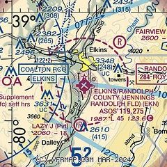
|
| Airport distance calculator |
|---|
|
|
| Sunrise and sunset |
|---|
|
Times for 11-Nov-2025
| | Local
(UTC-5) | | Zulu
(UTC) |
|---|
| Morning civil twilight | | 06:30 | | 11:30 |
| Sunrise | | 06:59 | | 11:59 |
| Sunset | | 17:08 | | 22:08 |
| Evening civil twilight | | 17:37 | | 22:37 |
|
| Current date and time |
|---|
| Zulu (UTC) | 11-Nov-2025 10:19:49 |
|---|
| Local (UTC-5) | 11-Nov-2025 05:19:49 |
|---|
|
| METAR |
|---|
| KEKN | 110951Z AUTO 27007G20KT 8SM -SN BKN021 OVC027 M06/M10 A3000 RMK AO2 SLP190 P0000 T10611100
|
|
| TAF |
|---|
| KEKN | 110521Z 1106/1206 29009G21KT 5SM -SN BR OVC035 TEMPO 1106/1107 30015G26KT 2SM -SHSN BR BKN020 FM110700 27011G21KT 6SM BR OVC020 TEMPO 1107/1111 2SM -SHSN BR BKN015 FM111200 25011G23KT 5SM BR OVC010 FM111600 28011G24KT P6SM BKN035 FM111800 27013G27KT P6SM SCT090 FM112300 21006KT P6SM SCT110
|
|
| NOTAMs |
|---|
NOTAMs are issued by the DoD/FAA and will open in a separate window not controlled by AirNav.
|
|

