FAA INFORMATION EFFECTIVE 16 APRIL 2026
Location
| FAA Identifier: | EKY |
| Lat/Long: | 33-18-45.4000N 086-55-34.7000W
33-18.756667N 086-55.578333W
33.3126111,-86.9263056
(estimated) |
| Elevation: | 699.6 ft. / 213.2 m (surveyed) |
| Variation: | 03W (2010) |
| From city: | 3 miles SE of BESSEMER, AL |
| Time zone: | UTC -5 (UTC -6 during Standard Time) |
| Zip code: | 35022 |
Airport Operations
| Airport use: | Open to the public |
| Activation date: | 03/1973 |
| Control tower: | no |
| ARTCC: | ATLANTA CENTER |
| FSS: | ANNISTON FLIGHT SERVICE STATION |
| NOTAMs facility: | ANB (NOTAM-D service available) |
| Attendance: | 0800-1800
FEE FOR AFT HRS SVC CALL 205-835-1415. |
| Wind indicator: | lighted |
| Segmented circle: | yes |
| Lights: | ACTVT REIL RWY 05 & 23; HIRL RWY 05/23 - CTAF. |
| Beacon: | white-green (lighted land airport)
Operates sunset to sunrise. |
Airport Communications
| CTAF/UNICOM: | 123.0 |
| WX AWOS-3PT: | 118.825 (205-424-3127) |
| BIRMINGHAM APPROACH: | 124.9 |
| BIRMINGHAM DEPARTURE: | 124.9 |
| CLEARANCE DELIVERY: | 123.75 |
| WX ASOS at EET (11 nm SE): | 134.325 (205-663-5881) |
| WX ASOS at BHM (17 nm NE): | PHONE 205-591-6172 |
Nearby radio navigation aids
| VOR radial/distance | | VOR name | | Freq | | Var |
|---|
| OKWr075/16.8 | | BROOKWOOD VORTAC | | 111.00 | | 00E |
| VUZr182/21.5 | | VULCAN VORTAC | | 114.40 | | 02E |
| NDB name | | Hdg/Dist | | Freq | | Var | | ID |
|---|
| MCDEN | | 202/12.6 | | 224 | | 03W | | BH | -... .... |
Airport Services
| Fuel available: | 100LL JET-A JET-A+ |
| Parking: | hangars and tiedowns |
| Airframe service: | MAJOR |
| Powerplant service: | MAJOR |
| Bottled oxygen: | HIGH/LOW |
| Bulk oxygen: | NONE |
Runway Information
Runway 5/23
| Dimensions: | 6007 x 100 ft. / 1831 x 30 m |
| Surface: | asphalt/grooved, in good condition |
| Weight bearing capacity: | | Single wheel: | 60.0 | | Double wheel: | 60.0 |
|
| Runway edge lights: | high intensity |
| RUNWAY 5 | | RUNWAY 23 |
| Latitude: | 33-18.437102N | | 33-19.076205N |
| Longitude: | 086-56.028720W | | 086-55.127518W |
| Elevation: | 699.3 ft. | | 699.5 ft. |
| Traffic pattern: | left | | left |
| Runway heading: | 053 magnetic, 050 true | | 233 magnetic, 230 true |
| Markings: | precision, in good condition | | nonprecision, in good condition |
| Visual slope indicator: | 4-light PAPI on left (3.00 degrees glide path) | | 4-light PAPI on left (3.00 degrees glide path) |
| Runway end identifier lights: | yes | | yes |
| Touchdown point: | yes, no lights | | yes, no lights |
| Instrument approach: | ILS/DME | | |
| Obstructions: | 33 ft. trees, 1136 ft. from runway, 346 ft. right of centerline, 28:1 slope to clear | | 30 ft. trees, 598 ft. from runway, 167 ft. right of centerline, 13:1 slope to clear |
Airport Ownership and Management from official FAA records
| Ownership: | Publicly-owned |
| Owner: | CITY OF BESSEMER
1700 N THIRD AVE
BESSEMER, AL 35020
Phone 205-424-4060 |
| Manager: | TIM WASYLUKA
900 MITCHELL FIELD RD
BESSEMER, AL 35022
Phone (205) 835-1415 |
Additional Remarks
| - | FOR CD IF UNA VIA FREQ, CTC BIRMINGHAM APCH AT 205-769-3890. |
Instrument Procedures
NOTE: All procedures below are presented as PDF files. If you need a reader for these files, you should download the free Adobe Reader.NOT FOR NAVIGATION. Please procure official charts for flight.
FAA instrument procedures published for use from 16 April 2026 at 0901Z to 14 May 2026 at 0900Z.
IAPs - Instrument Approach Procedures |
|---|
| ILS OR LOC RWY 05 | |
download (277KB) |
| RNAV (GPS) RWY 05 | |
download (226KB) |
| RNAV (GPS) RWY 23 | |
download (254KB) |
| VOR RWY 05 | |
download (225KB) |
| NOTE: Special Take-Off Minimums/Departure Procedures apply | |
download (522KB) |
Other nearby airports with instrument procedures:
KEET - Shelby County Airport (11 nm SE)
KBHM - Birmingham-Shuttlesworth International Airport (17 nm NE)
0A8 - Bibb County Airport (24 nm S)
02A - Chilton County Airport (32 nm SE)
KSCD - Merkel Field Sylacauga Municipal Airport (32 nm E)
|
|

Road maps at:
MapQuest
Bing
Google
| Aerial photo |
|---|
WARNING: Photo may not be current or correct
 Photo by Danny Schnautz
Photo taken 25-Mar-2015
looking northeast.
Photo by Danny Schnautz
Photo taken 25-Mar-2015
looking northeast.
Do you have a better or more recent aerial photo of Bessemer National Airport that you would like to share? If so, please send us your photo.
|
| Sectional chart |
|---|
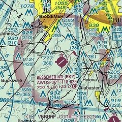
|
CAUTION: Diagram may not be current

| Airport distance calculator |
|---|
|
|
| Sunrise and sunset |
|---|
|
Times for 23-Apr-2026
| | Local
(UTC-5) | | Zulu
(UTC) |
|---|
| Morning civil twilight | | 05:43 | | 10:43 |
| Sunrise | | 06:09 | | 11:09 |
| Sunset | | 19:23 | | 00:23 |
| Evening civil twilight | | 19:49 | | 00:49 |
|
| Current date and time |
|---|
| Zulu (UTC) | 23-Apr-2026 10:44:07 |
|---|
| Local (UTC-5) | 23-Apr-2026 05:44:07 |
|---|
|
| METAR |
|---|
| KEKY | 230956Z AUTO 00000KT 10SM CLR 12/12 A3010 RMK AO2 SLP168 T01170117 $
|
KEET
11nm SE | 230953Z AUTO 00000KT 10SM CLR 11/11 A3009 RMK AO2 SLP186 T01110111
|
KBHM
18nm NE | 230953Z 00000KT 10SM CLR 12/11 A3011 RMK AO2 SLP190 T01220106
|
|
| TAF |
|---|
KEET
11nm SE | 230523Z 2306/2406 VRB02KT P6SM SCT250 FM231700 17006KT P6SM FEW250
|
KBHM
18nm NE | 230523Z 2306/2406 VRB02KT P6SM SCT250 FM231700 18007KT P6SM FEW250
|
|
| NOTAMs |
|---|
NOTAMs are issued by the DoD/FAA and will open in a separate window not controlled by AirNav.
|
|


