FAA INFORMATION EFFECTIVE 22 JANUARY 2026
Location
| FAA Identifier: | ELM |
| Lat/Long: | 42-09-35.4770N 076-53-30.2920W
42-09.591283N 076-53.504867W
42.1598547,-76.8917478
(estimated) |
| Elevation: | 955.1 ft. / 291.1 m (surveyed) |
| Variation: | 12W (2000) |
| From city: | 6 miles NW of central business district of the associated city |
| Time zone: | UTC -5 (UTC -4 during Daylight Saving Time) |
| Zip code: | 14845 |
Airport Operations
| Airport use: | Open to the public |
| Activation date: | 11/1940 |
| Control tower: | yes |
| ARTCC: | NEW YORK CENTER |
| FSS: | BUFFALO FLIGHT SERVICE STATION |
| NOTAMs facility: | ELM (NOTAM-D service available) |
| Attendance: | CONTINUOUS |
| Pattern altitude: | 2500.1 ft. MSL
TPA: 1545 FT AGL RECIPROCATING ENG, 2045 FT AGL TURBOPROP/JET. |
| Wind indicator: | lighted |
| Segmented circle: | no |
| Lights: | WHEN ATCT CLSD ACTVT MALSR RWY 06 & 24; HIRL RWY 06/24; MIRL RWY 10/28; TWY LGTS - CTAF. |
| Beacon: | white-green (lighted land airport)
Operates sunset to sunrise. |
| Landing fee: | yes, LNDG FEE FOR ALL NON BASED ACFT. |
| Fire and rescue: | ARFF index B |
| Airline operations: | ARFF INDEX "C" EQUIPMENT COVERAGE IS AVBL UPON REQUEST CTC ARPT MANAGEMENT AT 607-426-5621. |
| International operations: | customs landing rights airport |
Airport Communications
| CTAF: | 121.1 |
| UNICOM: | 122.95 |
| ATIS: | 125.475 |
| WX ASOS: | PHONE 607-796-0065 |
| ELMIRA GROUND: | 121.9 [0600-0000] |
| ELMIRA TOWER: | 121.1 257.8 [0600-0000] |
| ELMIRA APPROACH: | 128.425 257.8 [0600-0000] |
| NEW YORK ARTCC APPROACH: | 118.15 [0000-0600] |
| ELMIRA DEPARTURE: | 128.425 257.8 [0600-0000] |
| NEW YORK ARTCC DEPARTURE: | 118.15 [0000-0600] |
| CLEARANCE DELIVERY: | 121.9 |
| EMERG: | 121.5 243.0 |
| TRSA: | 128.425 257.8 |
- APCH/DEP SVC PRVDD BY NEW YORK ARTCC ON FREQS 133.35/372.0 (SAYRE RCAG) WHEN ELMIRA APCH CTL CLSD.
- FOR CLNC DEL WHEN ATCT CLSD CTC BUFFALO RADIO ON 122.2
Nearby radio navigation aids
| VOR radial/distance | | VOR name | | Freq | | Var |
|---|
| CFBr280/33.6 | | BINGHAMTON VOR/DME | | 112.20 | | 10W |
| SFKr048/36.5 | | STONYFORK VOR/DME | | 108.60 | | 08W |
| NDB name | | Hdg/Dist | | Freq | | Var | | ID |
|---|
| ALPINE | | 242/7.4 | | 245 | | 12W | | ALP | .- .-.. .--. |
Airport Services
| Fuel available: | 100LL JET-A |
| Parking: | hangars and tiedowns |
| Airframe service: | MAJOR |
| Powerplant service: | MAJOR |
| Bottled oxygen: | LOW |
| Bulk oxygen: | NONE |
Runway Information
Runway 6/24
| Dimensions: | 8001 x 150 ft. / 2439 x 46 m |
| Surface: | asphalt/grooved, in good condition |
| Weight bearing capacity: | | Single wheel: | 80.0 | | Double wheel: | 121.0 | | Double tandem: | 200.0 |
|
| Runway edge lights: | high intensity |
| RUNWAY 6 | | RUNWAY 24 |
| Latitude: | 42-09.216810N | | 42-10.056453N |
| Longitude: | 076-54.200998W | | 076-52.836908W |
| Elevation: | 942.8 ft. | | 955.0 ft. |
| Traffic pattern: | left | | left |
| Runway heading: | 062 magnetic, 050 true | | 242 magnetic, 230 true |
| Displaced threshold: | 600 ft. | | 202 ft. |
| Declared distances: | TORA:8001 TODA:8001 ASDA:8001 LDA:7401 | | TORA:8001 TODA:8001 ASDA:8001 LDA:7799 |
| Markings: | precision, in good condition | | precision, in good condition |
| Visual slope indicator: | 4-box VASI on left (3.00 degrees glide path) | | 4-light PAPI on left (3.00 degrees glide path)
PAPI UNUSBL BYD 9 DEGS RIGHT OF CNTRLN. |
| RVR equipment: | touchdown, midfield, rollout | | touchdown, midfield, rollout |
| Approach lights: | MALSR: 1,400 foot medium intensity approach lighting system with runway alignment indicator lights | | MALSR: 1,400 foot medium intensity approach lighting system with runway alignment indicator lights |
| Runway end identifier lights: | yes | | yes |
| Centerline lights: | yes | | yes |
| Touchdown point: | yes, no lights | | yes, no lights |
| Instrument approach: | ILS | | ILS |
| Obstructions: | 790 ft. tree, 27250 ft. from runway, 1800 ft. right of centerline, 34:1 slope to clear | | 382 ft. tree, 12329 ft. from runway, 2123 ft. right of centerline, 31:1 slope to clear |
Runway 10/28
| Dimensions: | 5404 x 150 ft. / 1647 x 46 m |
| Surface: | asphalt/grooved, in good condition |
| Weight bearing capacity: | | Single wheel: | 57.0 | | Double wheel: | 90.0 | | Double tandem: | 150.0 |
|
| Runway edge lights: | medium intensity |
| RUNWAY 10 | | RUNWAY 28 |
| Latitude: | 42-09.467727N | | 42-09.478892N |
| Longitude: | 076-54.176810W | | 076-52.981095W |
| Elevation: | 934.3 ft. | | 944.4 ft. |
| Traffic pattern: | left | | left |
| Runway heading: | 101 magnetic, 089 true | | 281 magnetic, 269 true |
| Displaced threshold: | no | | 402 ft. |
| Declared distances: | TORA:5404 TODA:5404 ASDA:5004 LDA:5004 | | TORA:5404 TODA:5404 ASDA:5404 LDA:5002 |
| Markings: | nonprecision, in good condition | | nonprecision, in good condition |
| Visual slope indicator: | | | 4-light PAPI on left (3.00 degrees glide path) |
| Touchdown point: | yes, no lights | | yes, no lights |
| Obstructions: | 632 ft. trees, 8761 ft. from runway, 1488 ft. left of centerline, 13:1 slope to clear | | 54 ft. pole, 1351 ft. from runway, 264 ft. left of centerline, 21:1 slope to clear |
Runway 5/23
| Dimensions: | 2016 x 150 ft. / 614 x 46 m |
| Surface: | turf, in good condition |
| Runway edge markings: | RWY 05/23 MKD WITH ASPH "L" CORNER MARKERS. |
| RUNWAY 5 | | RUNWAY 23 |
| Latitude: | 42-09.621445N | | 42-09.833272N |
| Longitude: | 076-53.421683W | | 076-53.078258W |
| Elevation: | 943.5 ft. | | 943.6 ft. |
| Traffic pattern: | left | | left |
| Runway heading: | 062 magnetic, 050 true | | 242 magnetic, 230 true |
| Declared distances: | TORA:2017 TODA:2017 ASDA:2017 LDA:2017 | | TORA:2017 TODA:2017 ASDA:2017 LDA:2017 |
| Touchdown point: | yes, no lights | | yes, no lights |
Airport Ownership and Management from official FAA records
| Ownership: | Publicly-owned |
| Owner: | COUNTY OF CHEMUNG
276 SING SING RD., SUITE 1
HORSEHEADS, NY 14845
Phone 607-739-5621
OR 607-739-5622. |
| Manager: | THOMAS FREEMAN
276 SING SING RD.,SUITE 1
HORSEHEADS, NY 14845
Phone 607-739-5621 |
Additional Remarks
| A39-06/24 | PCR VALUE: 560/F/B/X/T |
| A39-10/28 | PCR VALUE: 640/F/B/X/T |
| E60-06 | ENGINEERED MATERIALS ARRESTING SYSTEM (EMAS) 259 FT IN LENGTH BY 170 FT IN WIDTH LCTD AT DER 06. |
| - | ACFT WITH WINGSPANS GTR THAN 93 FEET SHOULD USE EXTREME CARE WHEN TAXIING ON TWY T ADJ TO APRONS. |
| - | RWY 10 OPNS PROHIBITED FOR ACFT WITH APCH SPEEDS GTR THAN OR EQUAL TO 121 KNOTS AND/OR WINGSPANS GTR THAN OR EQUAL TO 118 FT . |
| - | COLD TEMPERATURE AIRPORT. ALTITUDE CORRECTION REQUIRED AT OR BELOW -21C. |
| - | TWY H, J, & L LTD TO DESIGN GROUP II ACFT. |
| - | TRML RAMP IS UNCONTROLLED. DO NOT CALL FOR PUSH/POWER BACK. ADVISE GC WHEN READY TO TAXI FOR DEP. |
| - | TWY T BTN TXY L AND TWY D NONMOVEMENT AREA. |
| - | FOR CD IF UNA TO CTC ON FSS FREQ, CTC NEW YORK ARTCC AT 631-468-1425. |
| - | EXTSV GLIDER ACT ON & INVOF ARPT. |
| - | BIRDS & DEER ON & INVOF ARPT. |
| - | RWY 05/23 (SOUTHEAST OF RWY 06/24) UNMARKED SEASONAL USE TURF RWY CLSD 1 DEC THROUGH 30 APR. |
| - | FOR LAND SIDE ACCESS FM APRON WHEN FBO CLSD CTC ELM ARPT ATTENDANT AT 607-426-5621. |
| - | WINTER DE-ICING ON GLYCOL APRON ONLY. |
| - | BLIMP ACT RQRS PPR, CTC ARPT MGMT AT 607-426-5621. |
Instrument Procedures
NOTE: All procedures below are presented as PDF files. If you need a reader for these files, you should download the free Adobe Reader.NOT FOR NAVIGATION. Please procure official charts for flight.
FAA instrument procedures published for use from 22 January 2026 at 0901Z to 19 February 2026 at 0900z.
IAPs - Instrument Approach Procedures |
|---|
| ILS OR LOC RWY 06 | |
download (297KB) |
| ILS OR LOC RWY 24 | |
download (294KB) |
| RNAV (GPS) RWY 06 | |
download (236KB) |
| RNAV (GPS) RWY 10 | |
download (213KB) |
| RNAV (GPS) RWY 24 | |
download (290KB) |
| RNAV (GPS) RWY 28 | |
download (217KB) |
| NOTE: Special Alternate Minimums apply | |
download (122KB) |
| NOTE: Special Take-Off Minimums/Departure Procedures apply | |
download (379KB) |
Other nearby airports with instrument procedures:
KITH - Ithaca Tompkins International Airport (28 nm NE)
KPEO - Penn Yan/Yates County Airport (30 nm N)
N27 - Bradford County Airport (32 nm SE)
N38 - Grand Canyon Regional Airport (34 nm SW)
KCZG - Tri-Cities Airport (36 nm E)
|
|

Road maps at:
MapQuest
Bing
Google
| Aerial photo |
|---|
WARNING: Photo may not be current or correct
 Photo courtesy of AirNav, LLC
Photo taken 13-May-2014
looking northeast.
Photo courtesy of AirNav, LLC
Photo taken 13-May-2014
looking northeast.
Do you have a better or more recent aerial photo of Elmira/Corning Regional Airport that you would like to share? If so, please send us your photo.
|
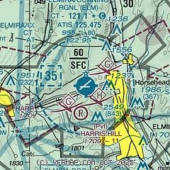
| Sectional chart |
|---|
|
CAUTION: Diagram may not be current
 Download PDF
of official airport diagram from the FAA
| Airport distance calculator |
|---|
|
|
| Sunrise and sunset |
|---|
|
Times for 04-Feb-2026
| | Local
(UTC-5) | | Zulu
(UTC) |
|---|
| Morning civil twilight | | 06:49 | | 11:49 |
| Sunrise | | 07:19 | | 12:19 |
| Sunset | | 17:25 | | 22:25 |
| Evening civil twilight | | 17:54 | | 22:54 |
|
| Current date and time |
|---|
| Zulu (UTC) | 04-Feb-2026 14:22:43 |
|---|
| Local (UTC-5) | 04-Feb-2026 09:22:43 |
|---|
|
| METAR |
|---|
| KELM | 041353Z 26006KT 10SM CLR M09/M14 A3025 RMK AO2 SLP261 T10941139
|
|
| TAF |
|---|
| KELM | 041141Z 0412/0512 27004KT P6SM BKN035 TEMPO 0412/0414 OVC025 FM041600 33005KT P6SM BKN035 FM050300 27003KT P6SM BKN025 FM050900 VRB03KT P6SM BKN015
|
|
| NOTAMs |
|---|
NOTAMs are issued by the DoD/FAA and will open in a separate window not controlled by AirNav.
|
|


