FAA INFORMATION EFFECTIVE 12 JUNE 2025
Location
| FAA Identifier: | EOE |
| Lat/Long: | 34-18-33.6000N 081-38-26.4000W
34-18.560000N 081-38.440000W
34.3093333,-81.6406667
(estimated) |
| Elevation: | 570.1 ft. / 173.8 m (surveyed) |
| Variation: | 07W (2010) |
| From city: | 3 miles N of NEWBERRY, SC |
| Time zone: | UTC -4 (UTC -5 during Standard Time) |
| Zip code: | 29108 |
Airport Operations
| Airport use: | Open to the public |
| Activation date: | 10/1946 |
| Control tower: | no |
| ARTCC: | JACKSONVILLE CENTER |
| FSS: | ANDERSON FLIGHT SERVICE STATION |
| NOTAMs facility: | AND (NOTAM-D service available) |
| Attendance: | UNATNDD |
| Wind indicator: | lighted |
| Segmented circle: | yes |
| Lights: | ACTIVATE - PAPI, MIRL RY 04/22 - CTAF. |
| Beacon: | white-green (lighted land airport)
Operates sunset to sunrise. |
Airport Communications
| CTAF/UNICOM: | 122.8 |
| WX AWOS-3: | 124.275 (803-276-2419) |
| COLUMBIA APPROACH: | 133.4 [0600-2300] |
| COLUMBIA DEPARTURE: | 133.4 [0600-2300] |
| WX AWOS-3 at LUX (19 nm NW): | 123.975 (864-682-3639) |
Nearby radio navigation aids
| VOR radial/distance | | VOR name | | Freq | | Var |
|---|
| CAEr315/39.8 | | COLUMBIA VORTAC | | 114.70 | | 02W |
| NDB name | | Hdg/Dist | | Freq | | Var | | ID |
|---|
| ENOREE | | at field | | 278 | | 07W | | EOE | . --- . |
| UNION COUNTY | | 186/22.5 | | 326 | | 06W | | UOT | ..- --- - |
| CHESTER | | 223/35.9 | | 220 | | 06W | | DCM | -.. -.-. -- |
| AIKEN | | 009/39.5 | | 347 | | 06W | | AIK | .- .. -.- |
Airport Services
| Fuel available: | 100LL
100LL:SELF-SERVE. |
| Parking: | tiedowns |
| Airframe service: | MAJOR |
| Powerplant service: | MAJOR |
| Bottled oxygen: | NONE |
| Bulk oxygen: | NONE |
Runway Information
Runway 4/22
| Dimensions: | 4001 x 75 ft. / 1220 x 23 m |
| Surface: | asphalt/aggregate friction seal coat, in excellent condition |
| Weight bearing capacity: | | Single wheel: | 23.0 | | Double wheel: | 30.0 |
|
| Runway edge lights: | medium intensity |
| RUNWAY 4 | | RUNWAY 22 |
| Latitude: | 34-18.295788N | | 34-18.822963N |
| Longitude: | 081-38.678097W | | 081-38.200443W |
| Elevation: | 535.6 ft. | | 570.1 ft. |
| Traffic pattern: | left | | right |
| Runway heading: | 044 magnetic, 037 true | | 224 magnetic, 217 true |
| Markings: | nonprecision, in good condition | | nonprecision, in good condition |
| Visual slope indicator: | 2-light PAPI on left (3.15 degrees glide path) | | 2-light PAPI on left (3.15 degrees glide path) |
| Touchdown point: | yes, no lights | | yes, no lights |
| Obstructions: | 96 ft. trees, 2379 ft. from runway, 271 ft. right of centerline, 22:1 slope to clear | | 34 ft. pole, 1025 ft. from runway, 191 ft. left of centerline, 24:1 slope to clear |
Airport Ownership and Management from official FAA records
| Ownership: | Publicly-owned |
| Owner: | NEWBERRY COUNTY
PO BOX 156
NEWBERRY, SC 29108
Phone 803-321-2100 |
| Manager: | JOSH ROWE
P.O. BOX 156, 1309 COLLEGE STREET
NEWBERRY, SC 29108
Phone 803-944-0613
(803) 321-2383 FAX. |
Additional Remarks
| - | DEER ON & INVOF ARPT. |
| - | FOR CD CTC COLUMBIA APCH AT 803-822-4511. |
Instrument Procedures
NOTE: All procedures below are presented as PDF files. If you need a reader for these files, you should download the free Adobe Reader.NOT FOR NAVIGATION. Please procure official charts for flight.
FAA instrument procedures published for use from 12 June 2025 at 0901Z to 10 July 2025 at 0900z.
IAPs - Instrument Approach Procedures |
|---|
| RNAV (GPS) RWY 04 | |
download (222KB) |
| RNAV (GPS) RWY 22 | |
download (216KB) |
| NDB RWY 22 | |
download (202KB) |
| NOTE: Special Alternate Minimums apply | |
download (167KB) |
| NOTE: Special Take-Off Minimums/Departure Procedures apply | |
download (141KB) |
Other nearby airports with instrument procedures:
KLUX - Laurens County Airport (19 nm NW)
35A - Union County Airport, Troy Shelton Field (23 nm N)
6J4 - Saluda County Airport (24 nm S)
KGRD - Greenwood County Airport (26 nm W)
KFDW - Fairfield County Airport (26 nm E)
|
|

Road maps at:
MapQuest
Bing
Google
| Aerial photo |
|---|
WARNING: Photo may not be current or correct
 Photo taken 19-Jun-2012
looking northeast.
Photo taken 19-Jun-2012
looking northeast.
Do you have a better or more recent aerial photo of Newberry County Airport that you would like to share? If so, please send us your photo.
|
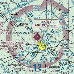
| Sectional chart |
|---|
|
| Airport distance calculator |
|---|
|
|
| Sunrise and sunset |
|---|
|
Times for 25-Jun-2025
| | Local
(UTC-4) | | Zulu
(UTC) |
|---|
| Morning civil twilight | | 05:48 | | 09:48 |
| Sunrise | | 06:17 | | 10:17 |
| Sunset | | 20:41 | | 00:41 |
| Evening civil twilight | | 21:11 | | 01:11 |
|
| Current date and time |
|---|
| Zulu (UTC) | 25-Jun-2025 20:09:17 |
|---|
| Local (UTC-4) | 25-Jun-2025 16:09:17 |
|---|
|
| METAR |
|---|
| KEOE | 251955Z AUTO 00000KT 10SM CLR 37/19 A3011 RMK AO2 LTG DSNT E
|
KLUX
19nm NW | 251955Z AUTO 07003KT 10SM CLR 36/21 A3009 RMK AO2
|
|
| TAF |
|---|
KCAE
34nm SE | 251726Z 2518/2618 11006KT P6SM VCTS SCT060CB TEMPO 2522/2602 VRB20G35KT 1SM TSRA SCT035 BKN060CB FM260200 VRB03KT P6SM VCSH BKN040 BKN120 FM260900 VRB03KT P6SM SCT150 FM261500 VRB06KT P6SM VCSH SCT050
|
KCUB
38nm SE | 251726Z 2518/2618 VRB05KT P6SM VCTS SCT060CB TEMPO 2522/2602 VRB20G35KT 1SM TSRA SCT035 BKN060CB FM260200 VRB03KT P6SM VCSH BKN040 BKN120 FM260900 VRB03KT P6SM SCT150 FM261500 VRB06KT P6SM VCSH SCT050
|
|
| NOTAMs |
|---|
NOTAMs are issued by the DoD/FAA and will open in a separate window not controlled by AirNav.
|
|


