FAA INFORMATION EFFECTIVE 14 MAY 2026
Location
| FAA Identifier: | 6J4 |
| Lat/Long: | 33-55-36.4550N 081-47-40.6600W
33-55.607583N 081-47.677667W
33.9267931,-81.7946278
(estimated) |
| Elevation: | 539.2 ft. / 164 m (estimated) |
| Variation: | 06W (2010) |
| From city: | 4 miles S of SALUDA, SC |
| Time zone: | UTC -4 (UTC -5 during Standard Time) |
| Zip code: | 29138 |
Airport Operations
| Airport use: | Open to the public |
| Activation date: | 01/1970 |
| Control tower: | no |
| ARTCC: | ATLANTA CENTER |
| FSS: | ANDERSON FLIGHT SERVICE STATION |
| NOTAMs facility: | AND (NOTAM-D service available) |
| Attendance: | MON-FRI 0800-1700, ALL SAT 0800-1200 |
| Wind indicator: | lighted |
| Segmented circle: | yes |
| Lights: | ACTVT PAPI RWY 01 & 19; MIRL RWY 01/19 - CTAF. |
| Beacon: | white-green (lighted land airport)
Operates sunset to sunrise. |
Airport Communications
| CTAF: | 122.9 |
| AUGUSTA APPROACH: | 119.15 124.15 ;WHEN AUGUSTA APCH CTL CLSD |
| COLUMBIA APPROACH: | 126.8 |
| AUGUSTA DEPARTURE: | 119.15 124.15 ;WHEN AUGUSTA APCH CTL CLSD |
| COLUMBIA DEPARTURE: | 126.8 |
| WX AWOS-3PT at AIK (18 nm S): | 118.025 (803-643-8664) |
Nearby radio navigation aids
| VOR radial/distance | | VOR name | | Freq | | Var |
|---|
| IRQr058/22.6 | | COLLIERS VORTAC | | 113.90 | | 04W |
| CAEr278/37.1 | | COLUMBIA VORTAC | | 114.70 | | 02W |
| NDB name | | Hdg/Dist | | Freq | | Var | | ID |
|---|
| AIKEN | | 346/17.5 | | 347 | | 06W | | AIK | .- .. -.- |
| EMORY | | 024/29.6 | | 385 | | 04W | | EMR | . -- .-. |
Airport Services
| Fuel available: | 100LL |
| Parking: | hangars and tiedowns |
| Airframe service: | MAJOR |
| Powerplant service: | MAJOR |
| Bottled oxygen: | NONE |
| Bulk oxygen: | NONE |
Runway Information
Runway 1/19
| Dimensions: | 3189 x 60 ft. / 972 x 18 m |
| Surface: | asphalt, in good condition |
| Weight bearing capacity: | |
| Runway edge lights: | medium intensity |
| RUNWAY 1 | | RUNWAY 19 |
| Latitude: | 33-55.347667N | | 33-55.867500N |
| Longitude: | 081-47.725000W | | 081-47.630333W |
| Elevation: | 536.8 ft. | | 522.3 ft. |
| Traffic pattern: | left | | left |
| Runway heading: | 015 magnetic, 009 true | | 195 magnetic, 189 true |
| Markings: | nonprecision, in good condition | | nonprecision, in good condition |
| Visual slope indicator: | 2-light PAPI on left (3.00 degrees glide path) | | 2-light PAPI on left |
| Runway end identifier lights: | no | | no |
| Touchdown point: | yes, no lights | | yes, no lights |
| Obstructions: | 64 ft. tree, 1891 ft. from runway, 220 ft. left of centerline, 26:1 slope to clear | | 133 ft. tree, 2362 ft. from runway, 319 ft. right of centerline, 16:1 slope to clear |
Airport Ownership and Management from official FAA records
| Ownership: | Publicly-owned |
| Owner: | SALUDA COUNTY
400 WEST HIGHLAND STREET
SALUDA, SC 29138
Phone 864-445-4500 |
| Manager: | JILL WARREN
111 LAW ENFORCEMENT DRIVE
SALUDA, SC 29138
Phone 864-445-2529 |
Additional Remarks
| - | 30 FT DROP OFF N END OF RWY 01. |
| - | FOR CD CTC AUGUSTA APCH AT 706-771-1777. WHEN AUGUSTA APCH CLSD, FOR CD CTC COLUMBIA APCH AT 803-822-4511. |
Instrument Procedures
NOTE: All procedures below are presented as PDF files. If you need a reader for these files, you should download the free Adobe Reader.NOT FOR NAVIGATION. Please procure official charts for flight.
FAA instrument procedures published for use from 14 May 2026 at 0901Z to 11 June 2026 at 0900Z.
IAPs - Instrument Approach Procedures |
|---|
| RNAV (GPS) RWY 01 | |
download (202KB) |
| RNAV (GPS) RWY 19 | |
download (222KB) |
| NOTE: Special Take-Off Minimums/Departure Procedures apply | |
download (141KB) |
Other nearby airports with instrument procedures:
KAIK - Aiken Regional Airport (18 nm S)
KEOE - Newberry County Airport (24 nm N)
KGRD - Greenwood County Airport (27 nm NW)
6J0 - Lexington County Airport (28 nm E)
KDNL - Daniel Field Airport (30 nm SW)
|
|

Road maps at:
MapQuest
Bing
Google
| Aerial photo |
|---|
WARNING: Photo may not be current or correct

Do you have a better or more recent aerial photo of Saluda County Airport that you would like to share? If so, please send us your photo.
|
| Sectional chart |
|---|
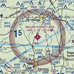
|
| Airport distance calculator |
|---|
|
|
| Sunrise and sunset |
|---|
|
Times for 31-May-2026
| | Local
(UTC-4) | | Zulu
(UTC) |
|---|
| Morning civil twilight | | 05:50 | | 09:50 |
| Sunrise | | 06:18 | | 10:18 |
| Sunset | | 20:31 | | 00:31 |
| Evening civil twilight | | 21:00 | | 01:00 |
|
| Current date and time |
|---|
| Zulu (UTC) | 31-May-2026 19:43:58 |
|---|
| Local (UTC-4) | 31-May-2026 15:43:58 |
|---|
|
| METAR |
|---|
KAIK
18nm S | 311855Z AUTO 06007KT 10SM OVC016 19/17 A3007 RMK AO2 LTG DSNT S T01870173
|
KEOE
24nm N | 311915Z AUTO 05004KT 10SM SCT027 20/12 A3011 RMK AO2 LTG DSNT SE
|
KGRD
26nm NW | 311856Z AUTO 07006KT 10SM OVC024 19/13 A3010 RMK AO2 SLP186 T01940133
|
KCAE
34nm E | 311856Z 07010KT 10SM OVC025 22/14 A3005 RMK AO2 SLP175 T02170144 $
|
KAGS
35nm S | 311853Z 05007KT 10SM OVC011 19/18 A3003 RMK AO2 RAE13 SLP168 P0000 T01940183 $
|
|
| TAF |
|---|
KAIK
18nm S | 311730Z 3118/0118 07007KT P6SM VCSH SCT008 OVC015 TEMPO 3118/3122 5SM -RA BR BKN008 FM312200 10005KT 6SM BR VCSH SCT007 OVC015 FM010600 VRB04KT 6SM BR VCSH OVC006 FM011500 VRB04KT P6SM SCT008 BKN025
|
|
| NOTAMs |
|---|
NOTAMs are issued by the DoD/FAA and will open in a separate window not controlled by AirNav.
|
|

