FAA INFORMATION EFFECTIVE 16 APRIL 2026
Location
| FAA Identifier: | EOP |
| Lat/Long: | 39-10-01.1000N 082-55-42.0000W
39-10.018333N 082-55.700000W
39.1669722,-82.9283333
(estimated) |
| Elevation: | 661.1 ft. / 201.5 m (surveyed) |
| Variation: | 06W (2000) |
| From city: | 3 miles NE of WAVERLY, OH |
| Time zone: | UTC -4 (UTC -5 during Standard Time) |
| Zip code: | 45690 |
Airport Operations
| Airport use: | Open to the public |
| Control tower: | no |
| ARTCC: | INDIANAPOLIS CENTER |
| FSS: | DAYTON FLIGHT SERVICE STATION |
| NOTAMs facility: | EOP (NOTAM-D service available) |
| Attendance: | MON-FRI 0830-1630
EXCLDG MAJOR HOLS. |
| Wind indicator: | lighted |
| Segmented circle: | no |
| Lights: | ACTVT REIL RWY 07 & 25; MIRL RWY 07/25 - CTAF. PAPI RWY 07 & 25 OPR CONSLY. |
| Beacon: | white-green (lighted land airport)
Operates sunset to sunrise. |
Airport Communications
| CTAF/UNICOM: | 123.0 |
| WX AWOS-3PT: | 121.45 (740-947-0035) |
| WX AWOS-3 at RZT (17 nm N): | 119.225 (740-779-1364) |
| WX AWOS-3PT at JRO (20 nm SE): | 118.825 (740-286-1760) |
| WX AWOS-3PT at PMH (20 nm S): | 125.175 (740-820-2500) |
- APCH/DEP SVC PRVDD BY INDIANAPOLIS ARTCC ON FREQ 135.575/290.5 (PORTSMOUTH RCAG).
Nearby radio navigation aids
| VOR radial/distance | | VOR name | | Freq | | Var |
|---|
| XUBr179/(21.7) | | YELLOW BUD VOR | | 112.50 | | 05W |
| NDB name | | Hdg/Dist | | Freq | | Var | | ID |
|---|
| COURT HOUSE | | 146/33.8 | | 414 | | 06W | | CSS | -.-. ... ... |
| UNIVERSITY | | 268/37.7 | | 250 | | 06W | | UGS | ..- --. ... |
Airport Services
| Fuel available: | 100LL JET-A1+
100LL:FUEL AVBL H24 SELF SVC VIA CREDIT CARD. |
| Parking: | tiedowns |
| Airframe service: | MAJOR |
| Powerplant service: | MAJOR |
| Bottled oxygen: | NONE |
| Bulk oxygen: | NONE |
Runway Information
Runway 7/25
| Dimensions: | 4899 x 75 ft. / 1493 x 23 m |
| Surface: | asphalt, in good condition |
| Weight bearing capacity: | |
| Runway edge lights: | medium intensity |
| RUNWAY 7 | | RUNWAY 25 |
| Latitude: | 39-09.829377N | | 39-10.207002N |
| Longitude: | 082-56.157765W | | 082-55.241542W |
| Elevation: | 658.6 ft. | | 660.7 ft. |
| Traffic pattern: | left | | left |
| Runway heading: | 068 magnetic, 062 true | | 248 magnetic, 242 true |
| Markings: | nonprecision, in fair condition | | nonprecision, in fair condition |
| Visual slope indicator: | 4-light PAPI on left (4.00 degrees glide path) | | 4-light PAPI on left (3.00 degrees glide path) |
| Runway end identifier lights: | yes | | yes |
| Touchdown point: | yes, no lights | | yes, no lights |
| Obstructions: | 10 ft. road, 201 ft. from runway, 205 ft. left of centerline
+10 FT ROAD, 0-200 FT DIST, 205 FT L; +8 FT FENCE, 110-200 FT DIST, 180-190 FT L. | | 46 ft. tree, 664 ft. from runway, 315 ft. left of centerline, 10:1 slope to clear |
Airport Ownership and Management from official FAA records
| Ownership: | Publicly-owned |
| Owner: | PIKE COUNTY COMMISSIONERS
230 WAVERLY PLZ STE 100
WAVERLY, OH 45690-1288
Phone 740-947-4817 |
| Manager: | SARA JUNK
2577 ALMA OMEGA RD
WAVERLY, OH 45690-9316
Phone 740-947-4952
CELL 740-577-2644. |
Additional Remarks
| - | BIRDS & OTR WILDLIFE ON & INVOF ARPT. |
| - | FOR CD CTC INDIANAPOLIS ARTCC AT 317-247-2411. |
Instrument Procedures
NOTE: All procedures below are presented as PDF files. If you need a reader for these files, you should download the free Adobe Reader.NOT FOR NAVIGATION. Please procure official charts for flight.
FAA instrument procedures published for use from 16 April 2026 at 0901Z to 14 May 2026 at 0900Z.
IAPs - Instrument Approach Procedures |
|---|
| RNAV (GPS) RWY 07 | |
download (214KB) |
| RNAV (GPS) RWY 25 | |
download (231KB) |
| NOTE: Special Take-Off Minimums/Departure Procedures apply | |
download (487KB) |
Other nearby airports with instrument procedures:
KRZT - Ross County Airport (17 nm N)
KJRO - James A Rhodes Airport (20 nm SE)
KPMH - Greater Portsmouth Regional Airport (20 nm S)
KCYO - Pickaway County Memorial Airport (21 nm N)
KHOC - Highland County Airport (28 nm W)
|
|

Road maps at:
MapQuest
Bing
Google
| Aerial photo |
|---|
WARNING: Photo may not be current or correct

Do you have a better or more recent aerial photo of Pike County Airport that you would like to share? If so, please send us your photo.
|
| Sectional chart |
|---|
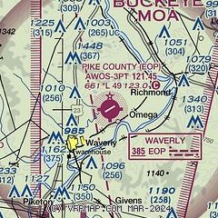
|
CAUTION: Diagram may not be current

| Airport distance calculator |
|---|
|
|
| Sunrise and sunset |
|---|
|
Times for 01-May-2026
| | Local
(UTC-4) | | Zulu
(UTC) |
|---|
| Morning civil twilight | | 06:05 | | 10:05 |
| Sunrise | | 06:34 | | 10:34 |
| Sunset | | 20:23 | | 00:23 |
| Evening civil twilight | | 20:52 | | 00:52 |
|
| Current date and time |
|---|
| Zulu (UTC) | 01-May-2026 09:04:35 |
|---|
| Local (UTC-4) | 01-May-2026 05:04:35 |
|---|
|
| METAR |
|---|
| KEOP | 010855Z AUTO 00000KT 10SM SCT002 02/02 A2995 RMK AO2
|
KRZT
17nm N | 010833Z AUTO 18005KT 10SM CLR 04/04 A2995 RMK AO2
|
KJRO
20nm SE | 010855Z AUTO 08001KT 9SM CLR 01/01 A2997 RMK AO2
|
KPMH
20nm S | 010835Z AUTO RMK AO2 PWINO
|
|
| TAF |
|---|
KLCK
39nm N | 010522Z 0106/0206 18003KT P6SM SCT070 FM011200 22006KT P6SM -SHRA OVC035 TEMPO 0115/0117 6SM -SHRA OVC025 FM011700 30010KT P6SM BKN022 FM011900 32012G19KT P6SM BKN040 FM020000 30005KT P6SM SCT035
|
KILN
44nm W | 010522Z 0106/0206 19005KT P6SM SCT070 FM011200 24009KT P6SM -SHRA OVC035 TEMPO 0115/0117 6SM -SHRA OVC028 FM011700 30012KT P6SM BKN025 FM011800 32014G22KT P6SM BKN040 FM020000 30007KT P6SM SCT035
|
|
| NOTAMs |
|---|
NOTAMs are issued by the DoD/FAA and will open in a separate window not controlled by AirNav.
|
|


