FAA INFORMATION EFFECTIVE 19 MARCH 2026
Location
| FAA Identifier: | EWB |
| Lat/Long: | 41-40-35.6380N 070-57-28.2100W
41-40.593967N 070-57.470167W
41.6765661,-70.9578361
(estimated) |
| Elevation: | 79.1 ft. / 24.1 m (surveyed) |
| Variation: | 16W (1995) |
| From city: | 2 miles NW of NEW BEDFORD, MA |
| Time zone: | UTC -4 (UTC -5 during Standard Time) |
| Zip code: | 02745 |
Airport Operations
| Airport use: | Open to the public |
| Activation date: | 04/1942 |
| Control tower: | yes |
| ARTCC: | BOSTON CENTER |
| FSS: | BRIDGEPORT FLIGHT SERVICE STATION |
| NOTAMs facility: | EWB (NOTAM-D service available) |
| Attendance: | 0600-2300 |
| Wind indicator: | yes |
| Segmented circle: | no |
| Lights: | WHEN ATCT CLSD ACTVT MALSR RWYS 05 & 23; REIL RWY 32; HIRL RWY 05/23; MIRL RWY 14/32 - CTAF. PAPI RWYS 14, 23 & 32 OPR 24 HRS. |
| Beacon: | white-green (lighted land airport)
Operates sunset to sunrise. |
| Fire and rescue: | ARFF index A |
| International operations: | customs landing rights airport |
Airport Communications
| CTAF: | 118.1 |
| UNICOM: | 122.95 |
| ATIS: | 126.85 |
| WX ASOS: | 126.85 (508-992-0195) |
| NEW BEDFORD GROUND: | 121.9 [0630-2200] |
| NEW BEDFORD TOWER: | 118.1 239.0 [0630-2200] |
| PROVIDENCE APPROACH: | 128.7 |
| PROVIDENCE DEPARTURE: | 128.7 |
| EMERG: | 121.5 243.0 |
| WIPOR STAR: | 123.675 |
| WX ASOS at TAN (12 nm N): | 132.675 (508-824-5005) |
| WX ASOS at UUU (17 nm SW): | 132.075 (401-846-5910) |
| WX ASOS at PYM (17 nm NE): | 135.625 (508-319-1421) |
| WX ASOS at FMH (20 nm E): | PHONE 508-968-6562 |
- APCH/DEP SVC PRVDD BY BOSTON ARTCC ON FREQS 124.85/307.9 (WOODSTOCK RCAG) WHEN PROVIDENCE APCH CTL CLSD.
Nearby radio navigation aids
| VOR radial/distance | | VOR name | | Freq | | Var |
|---|
| PVDr112/21.3 | | PROVIDENCE VOR/DME | | 115.60 | | 14W |
| MVYr332/22.9 | | MARTHAS VINEYARD VOR/DME | | 114.50 | | 15W |
Airport Services
| Fuel available: | 100LL JET-A |
| Parking: | hangars and tiedowns |
| Airframe service: | MAJOR |
| Powerplant service: | MAJOR |
| Bottled oxygen: | HIGH/LOW |
Runway Information
Runway 5/23
| Dimensions: | 5400 x 150 ft. / 1646 x 46 m |
| Surface: | asphalt/grooved, in good condition |
| Weight bearing capacity: | | Single wheel: | 30.0 | | Double wheel: | 108.0 | | Double tandem: | 195.0 |
|
| Runway edge lights: | high intensity |
| Operational restrictions: | RWY 05/23 NOT AVBL FOR PART 121/PART 380 OPS WITH SKED PAX CARRYING OPS MORE THAN 9 PAX SEATS AND NON-SKED PAX CARRYING OPS MORE THAN 30 PAX SEATS. 90 DAY PPR FOR UNSKED ACR OPS GTR THAN 30 PAX SEATS - CALL AMGR. |
| RUNWAY 5 | | RUNWAY 23 |
| Latitude: | 41-40.275628N | | 41-40.972012N |
| Longitude: | 070-57.898063W | | 070-57.160703W |
| Elevation: | 64.4 ft. | | 79.1 ft. |
| Traffic pattern: | left | | left |
| Runway heading: | 054 magnetic, 038 true | | 234 magnetic, 218 true |
| Displaced threshold: | no | | 400 ft. |
| Markings: | precision, in good condition | | precision, in good condition |
| Visual slope indicator: | | | 4-light PAPI on left (3.00 degrees glide path) |
| RVR equipment: | touchdown | | rollout |
| Approach lights: | MALSR: 1,400 foot medium intensity approach lighting system with runway alignment indicator lights | | MALSR: 1,400 foot medium intensity approach lighting system with runway alignment indicator lights |
| Touchdown point: | yes, no lights | | yes, no lights |
| Instrument approach: | ILS/DME | | |
| Obstructions: | 20 ft. tree, 1200 ft. from runway | | 35 ft. tree, 1400 ft. from runway, 125 ft. both sides of centerline, 34:1 slope to clear
APCH SLP 50:1 AT DTHR. |
Runway 14/32
| Dimensions: | 5002 x 75 ft. / 1525 x 23 m |
| Surface: | asphalt, in fair condition |
| Weight bearing capacity: | | Single wheel: | 33.0 | | Double wheel: | 48.0 | | Double tandem: | 95.0 |
|
| Runway edge lights: | medium intensity |
| Operational restrictions: | RWY 14/32 NOT AVBL FOR PART 121/PART 380 OPS WITH SKED PAX CARRYING OPS MORE THAN 9 PAX SEATS AND NON-SKED PAX CARRYING OPS MORE THAN 30 PAX SEATS. 90 DAY PPR FOR UNSKED ACR OPS GTR THAN 30 PAX SEATS - CALL AMGR. |
| RUNWAY 14 | | RUNWAY 32 |
| Latitude: | 41-40.818012N | | 41-40.305425N |
| Longitude: | 070-57.836148W | | 070-56.976313W |
| Elevation: | 77.3 ft. | | 66.2 ft. |
| Traffic pattern: | left | | left |
| Runway heading: | 144 magnetic, 128 true | | 324 magnetic, 308 true |
| Markings: | basic, in good condition | | basic, in good condition |
| Visual slope indicator: | 4-light PAPI on left (3.42 degrees glide path) | | 4-light PAPI on left (3.50 degrees glide path) |
| Runway end identifier lights: | | | yes |
| Touchdown point: | yes, no lights | | yes, no lights |
| Obstructions: | 10 ft. tree, 400 ft. from runway, 20:1 slope to clear | | 11 ft. trees, 600 ft. from runway, 130 ft. right of centerline, 36:1 slope to clear |
Airport Ownership and Management from official FAA records
| Ownership: | Publicly-owned |
| Owner: | CITY OF NEW BEDFORD
133 WILLIAMS ST
NEW BEDFORD, MA 02740
Phone 508-979-1410 |
| Manager: | SCOT SERVIS
1569 AIRPORT RD
NEW BEDFORD, MA 02746
Phone 508-991-6161 |
Additional Remarks
| A39-05/23 | PCR VALUE: 810/F/A/X/T |
| A39-14/32 | PCR VALUE: 930/F/A/X/T |
| - | BIRDS & WILDLIFE ON & INVOF ARPT. |
| - | LDG FEES FOR ACFT OVR 3000 LBS. |
| - | FOR CD WHEN APCH CLSD CTC BOSTON ARTCC AT 603-879-6859. |
| - | TWYS A1 & A2 FOR ACR ACFT ONLY. |
Instrument Procedures
NOTE: All procedures below are presented as PDF files. If you need a reader for these files, you should download the free Adobe Reader.NOT FOR NAVIGATION. Please procure official charts for flight.
FAA instrument procedures published for use from 19 March 2026 at 0901Z to 16 April 2026 at 0900Z.
STARs - Standard Terminal Arrivals |
|---|
| WIPOR FOUR (RNAV) | |
download (284KB) |
IAPs - Instrument Approach Procedures |
|---|
| ILS OR LOC RWY 05 | |
download (351KB) |
| RNAV (GPS) RWY 05 | |
download (362KB) |
| RNAV (GPS) RWY 14 | |
download (280KB) |
| RNAV (GPS) RWY 23 | |
download (292KB) |
| RNAV (GPS) RWY 32 | |
download (294KB) |
| LOC BC RWY 23 | |
download (289KB) |
| NOTE: Special Alternate Minimums apply | |
download (153KB) |
| NOTE: Special Take-Off Minimums/Departure Procedures apply | |
download (517KB) |
Other nearby airports with instrument procedures:
KTAN - Taunton Municipal Airport/King Field (12 nm N)
KUUU - Newport State Airport (17 nm SW)
KPYM - Plymouth Municipal Airport (17 nm NE)
5B6 - Falmouth Airpark (20 nm E)
KFMH - Cape Cod Coast Guard Air Station (20 nm E)
|
|

Road maps at:
MapQuest
Bing
Google
| Aerial photo |
|---|
WARNING: Photo may not be current or correct
 Photo by Grant Powers
Photo taken 10-Oct-2014
looking southeast.
Photo by Grant Powers
Photo taken 10-Oct-2014
looking southeast.
Do you have a better or more recent aerial photo of New Bedford Regional Airport that you would like to share? If so, please send us your photo.
|
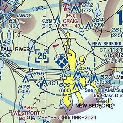
| Sectional chart |
|---|
|
CAUTION: Diagram may not be current
 Download PDF
of official airport diagram from the FAA
| Airport distance calculator |
|---|
|
|
| Sunrise and sunset |
|---|
|
Times for 31-Mar-2026
| | Local
(UTC-4) | | Zulu
(UTC) |
|---|
| Morning civil twilight | | 06:02 | | 10:02 |
| Sunrise | | 06:30 | | 10:30 |
| Sunset | | 19:07 | | 23:07 |
| Evening civil twilight | | 19:35 | | 23:35 |
|
| Current date and time |
|---|
| Zulu (UTC) | 01-Apr-2026 03:41:35 |
|---|
| Local (UTC-4) | 31-Mar-2026 23:41:35 |
|---|
|
| METAR |
|---|
| KEWB | 010253Z AUTO 00000KT 10SM CLR 08/07 A2994 RMK AO2 SLP138 T00830072 58006
|
KTAN
13nm N | 010252Z AUTO 00000KT 5SM BR OVC004 06/05 A2994 RMK AO2 SLP139 T00610050 56009
|
KUUU
17nm SW | 010253Z AUTO 20007KT 9SM CLR 09/08 A2995 RMK AO2 SLP139 T00890078 56004 $
|
KPYM
18nm NE | 010252Z AUTO 00000KT 1/2SM FG VV003 06/06 A2993 RMK AO2 SLP139 T00560056 57009 $
|
KFMH
20nm E | 010256Z 23014KT 8SM FEW011 11/09 A2997
|
|
| TAF |
|---|
KFMH
20nm E | 311720Z 3118/0118 24014G25KT P6SM BKN090 WS020/24045KT FM010000 23007KT P6SM BKN010 WS020/24045KT FM010300 23012G22KT P6SM BKN030 WS020/24050KT FM010500 23013G24KT P6SM SCT070 WS020/24055KT FM011200 23013G23KT 4SM BR BKN012 WS020/25050KT PROB30 0112/0116 2SM -RA BR OVC008
|
KPVD
21nm W | 312010Z 3120/0118 24012KT P6SM BKN110 FM312200 18007KT P6SM SCT150 WS020/24035KT PROB30 0110/0113 4SM -RA BKN070 FM011300 23010KT P6SM -RA BKN030 WS020/25045KT FM011600 24009KT P6SM BKN030 PROB30 0116/0117 4SM -RA OVC015
|
|
| NOTAMs |
|---|
NOTAMs are issued by the DoD/FAA and will open in a separate window not controlled by AirNav.
|
|


