FAA INFORMATION EFFECTIVE 09 JULY 2026
Location
| FAA Identifier: | F23 |
| Lat/Long: | 32-27-05.3100N 098-40-53.4450W
32-27.088500N 098-40.890750W
32.4514750,-98.6815125
(estimated) |
| Elevation: | 1470 ft. / 448 m (estimated) |
| Variation: | 07E (1985) |
| From city: | 2 miles S of RANGER, TX |
| Time zone: | UTC -5 (UTC -6 during Standard Time) |
| Zip code: | 76470 |
Airport Operations
| Airport use: | Open to the public |
| Activation date: | 11/1938 |
| Control tower: | no |
| ARTCC: | FORT WORTH CENTER |
| FSS: | FORT WORTH FLIGHT SERVICE STATION |
| NOTAMs facility: | FTW (NOTAM-D service available) |
| Attendance: | DAYLIGHT HOURS |
| Wind indicator: | yes |
| Segmented circle: | no |
Airport Communications
| CTAF: | 122.9 |
| WX AWOS-3PT at ETN (7 nm W): | 118.45 (254-631-0493) |
| WX AWOS-4 at GZN (18 nm W): | 118.0 (254-442-1185) |
| WX AWOS-3 at BKD (19 nm NW): | 120.175 (254-559-5525) |
Nearby radio navigation aids
| VOR radial/distance | | VOR name | | Freq | | Var |
|---|
| BWDr015/36.3 | | BROWNWOOD VOR/DME | | 113.55 | | 08E |
| MQPr236/38.3 | | MILLSAP VORTAC | | 117.70 | | 09E |
Airport Services
| Parking: | hangars and tiedowns |
Runway Information
Runway 1/19
| Dimensions: | 3415 x 75 ft. / 1041 x 23 m |
| Surface: | turf, in good condition |
| RUNWAY 1 | | RUNWAY 19 |
| Latitude: | 32-26.825667N | | 32-27.351333N |
| Longitude: | 098-41.010000W | | 098-40.771500W |
| Elevation: | 1457.0 ft. | | 1469.0 ft. |
| Traffic pattern: | left | | left |
| Obstructions: | 20 ft. trees, 200 ft. from runway, 135 ft. left of centerline, 10:1 slope to clear | | 16 ft. trees, 30 ft. from runway, 76 ft. left and right of centerline, 1:1 slope to clear |
Runway 18/36
| Dimensions: | 1850 x 80 ft. / 564 x 24 m |
| Surface: | turf, in good condition |
| RUNWAY 18 | | RUNWAY 36 |
| Traffic pattern: | left | | left |
| Obstructions: | 18 ft. bldg, 158 ft. from runway, 25 ft. right of centerline, 9:1 slope to clear | | 21 ft. tree, 300 ft. from runway, 145 ft. right of centerline, 14:1 slope to clear |
Airport Ownership and Management from official FAA records
| Ownership: | Publicly-owned |
| Owner: | CITY OF RANGER
400 W. MAIN
RANGER, TX 76470
Phone 254-647-3522 |
| Manager: | JARED CALVERT
1420 ODDIE ST
RANGER, TX 76470
Phone 254-433-1267 |
Additional Remarks
| - | PEDESTRIAN TFC ON FLD AT TIMES. |
| - | RWY 01 & 19 THR MKD BY WHITE TIRES. |
| - | DEER ON & INVOF ARPT. |
| - | FOR CD CTC FORT WORTH ARTCC AT 817-858-7584. |
Instrument Procedures
There are no published instrument procedures at F23.
Some nearby airports with instrument procedures:
KETN - Eastland Municipal Airport (7 nm W)
KGZN - Gregory M Simmons Memorial Airport (18 nm W)
KBKD - Stephens County Airport (19 nm NW)
KSEP - Stephenville Clark Regional Airport (29 nm SE)
F35 - Possum Kingdom Airport (31 nm NE)
|
|

Road maps at:
MapQuest
Bing
Google
| Aerial photo |
|---|
WARNING: Photo may not be current or correct

Do you have a better or more recent aerial photo of Ranger Municipal Airport that you would like to share? If so, please send us your photo.
|
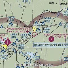
| Sectional chart |
|---|
|
| Airport distance calculator |
|---|
|
|
| Sunrise and sunset |
|---|
|
Times for 29-Jul-2026
| | Local
(UTC-5) | | Zulu
(UTC) |
|---|
| Morning civil twilight | | 06:21 | | 11:21 |
| Sunrise | | 06:48 | | 11:48 |
| Sunset | | 20:34 | | 01:34 |
| Evening civil twilight | | 21:01 | | 02:01 |
|
| Current date and time |
|---|
| Zulu (UTC) | 29-Jul-2026 05:48:19 |
|---|
| Local (UTC-5) | 29-Jul-2026 00:48:19 |
|---|
|
| METAR |
|---|
KETN
7nm W | 290535Z AUTO 00000KT 10SM CLR 26/18 A2991 RMK AO2 T02580183
|
KGZN
18nm W | 290535Z AUTO 16005KT 10SM FEW035 FEW042 SCT048 25/19 A2990 RMK AO2
|
KBKD
19nm NW | 290535Z AUTO 17007KT 7SM CLR 29/18 A2988 RMK AO2 T02930183
|
|
| NOTAMs |
|---|
NOTAMs are issued by the DoD/FAA and will open in a separate window not controlled by AirNav.
|
|


