FAA INFORMATION EFFECTIVE 14 MAY 2026
Location
| FAA Identifier: | ETN |
| Lat/Long: | 32-24-53.6000N 098-48-34.9000W
32-24.893333N 098-48.581667W
32.4148889,-98.8096944
(estimated) |
| Elevation: | 1467.9 ft. / 447.4 m (surveyed) |
| Variation: | 07E (1995) |
| From city: | 1 mile N of EASTLAND, TX |
| Time zone: | UTC -5 (UTC -6 during Standard Time) |
| Zip code: | 76448 |
Airport Operations
| Airport use: | Open to the public |
| Activation date: | 10/1945 |
| Control tower: | no |
| ARTCC: | FORT WORTH CENTER |
| FSS: | FORT WORTH FLIGHT SERVICE STATION |
| NOTAMs facility: | FTW (NOTAM-D service available) |
| Attendance: | MON-SAT 0800-1800 |
| Wind indicator: | lighted |
| Segmented circle: | yes |
| Lights: | ACTVT PAPI RWY 17 & 35, MIRL RWY 17/35 - CTAF. |
| Beacon: | white-green (lighted land airport)
Operates sunset to sunrise. |
Airport Communications
| CTAF/UNICOM: | 122.8 |
| WX AWOS-3PT: | 118.45 (254-631-0493) |
| WX AWOS-4 at GZN (11 nm W): | 118.0 (254-442-1185) |
| WX AWOS-3 at BKD (19 nm N): | 120.175 (254-559-5525) |
- APCH/DEP SVC PRVDD BY FORT WORTH ARTCC (ZFW) ON FREQS 135.375/354.05 (DUBLIN RCAG).
Nearby radio navigation aids
| VOR radial/distance | | VOR name | | Freq | | Var |
|---|
| BWDr005/32.2 | | BROWNWOOD VOR/DME | | 113.55 | | 08E |
Airport Services
| Fuel available: | 100LL JET-A
100LL:AFT FUEL HRS CALL 254-488-1055. |
| Parking: | hangars and tiedowns |
| Airframe service: | MAJOR |
| Powerplant service: | MINOR |
| Bulk oxygen: | NONE |
Runway Information
Runway 17/35
| Dimensions: | 5000 x 60 ft. / 1524 x 18 m |
| Surface: | asphalt, in good condition |
| Weight bearing capacity: | |
| Runway edge lights: | medium intensity |
| RUNWAY 17 | | RUNWAY 35 |
| Latitude: | 32-25.305500N | | 32-24.481262N |
| Longitude: | 098-48.566500W | | 098-48.597425W |
| Elevation: | 1467.9 ft. | | 1445.5 ft. |
| Traffic pattern: | left | | left |
| Runway heading: | 175 magnetic, 182 true | | 355 magnetic, 002 true |
| Displaced threshold: | 980 ft. | | 420 ft. |
| Markings: | nonprecision, in good condition | | nonprecision, in good condition |
| Visual slope indicator: | 2-light PAPI on left (3.50 degrees glide path) | | 2-light PAPI on left (3.00 degrees glide path) |
| Touchdown point: | yes, no lights | | yes, no lights |
| Obstructions: | 114 ft. pole, lighted, 1814 ft. from runway, 33 ft. left of centerline, 14:1 slope to clear
APCH SLOPE 23:1 TO DSPLCD THR. | | 51 ft. trees, 1340 ft. from runway, 370 ft. right of centerline, 22:1 slope to clear
APCH SLOPE 34:1 TO DSPLCD THR. |
Airport Ownership and Management from official FAA records
| Ownership: | Publicly-owned |
| Owner: | CITY OF EASTLAND
PO BOX 749
EASTLAND, TX 76448
Phone 254-629-8321 |
| Manager: | BODE ZIETZ
PO BOX 47
EASTLAND, TX 76448
Phone 254-629-1588
MGR CELL 254-488-1055 |
Additional Remarks
| - | FOR CD CTC FORT WORTH ARTCC AT 817-858-7584. |
| - | TRML AVBL 24/7 FOR FLT CREWS. |
| - | 183 FT AGL, 1617 MSL UNLTD/UNMKD ANT, 1000 FM RWY 35 END, 1500 FT R. |
Instrument Procedures
NOTE: All procedures below are presented as PDF files. If you need a reader for these files, you should download the free Adobe Reader.NOT FOR NAVIGATION. Please procure official charts for flight.
FAA instrument procedures published for use from 14 May 2026 at 0901Z to 11 June 2026 at 0900Z.
IAPs - Instrument Approach Procedures |
|---|
| RNAV (GPS) RWY 17 | |
download (214KB) |
| RNAV (GPS) RWY 35 | |
download (217KB) |
| NOTE: Special Alternate Minimums apply | |
download (117KB) |
| NOTE: Special Take-Off Minimums/Departure Procedures apply | |
download (113KB) |
Other nearby airports with instrument procedures:
KGZN - Gregory M Simmons Memorial Airport (11 nm W)
KBKD - Stephens County Airport (19 nm N)
T23 - Albany Municipal Airport (30 nm NW)
KMKN - Comanche County-City Airport (32 nm S)
KSEP - Stephenville Clark Regional Airport (34 nm E)
|
|

Road maps at:
MapQuest
Bing
Google
| Aerial photo |
|---|
WARNING: Photo may not be current or correct
 Photo by Bode Zietz
Photo taken 24-Jul-2019
looking south.
Photo by Bode Zietz
Photo taken 24-Jul-2019
looking south.
Do you have a better or more recent aerial photo of Eastland Municipal Airport that you would like to share? If so, please send us your photo.
|
| Sectional chart |
|---|
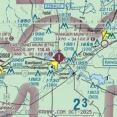
|
CAUTION: Diagram may not be current

| Airport distance calculator |
|---|
|
|
| Sunrise and sunset |
|---|
|
Times for 05-Jun-2026
| | Local
(UTC-5) | | Zulu
(UTC) |
|---|
| Morning civil twilight | | 06:01 | | 11:01 |
| Sunrise | | 06:29 | | 11:29 |
| Sunset | | 20:38 | | 01:38 |
| Evening civil twilight | | 21:07 | | 02:07 |
|
| Current date and time |
|---|
| Zulu (UTC) | 05-Jun-2026 13:23:07 |
|---|
| Local (UTC-5) | 05-Jun-2026 08:23:07 |
|---|
|
| METAR |
|---|
| KETN | 051255Z AUTO 16006KT 10SM SCT005 SCT012 SCT030 22/21 A2996 RMK AO2 T02180212
|
KGZN
11nm W | 051255Z AUTO 17011KT 10SM 23/23 A2995 RMK AO2 FZRANO
|
KBKD
19nm N | 051255Z AUTO 00000KT 5SM OVC025 24/22 A2995 RMK AO2 T02380224
|
|
| TAF |
|---|
KABI
44nm W | 051124Z 0512/0612 16008KT P6SM SCT012 TEMPO 0512/0516 BKN012 FM051700 17010KT P6SM BKN100 PROB30 0519/0524 -TSRA BKN050CB
|
|
| NOTAMs |
|---|
NOTAMs are issued by the DoD/FAA and will open in a separate window not controlled by AirNav.
|
|


