FAA INFORMATION EFFECTIVE 14 MAY 2026
Location
| FAA Identifier: | F35 |
| Lat/Long: | 32-55-23.9685N 098-26-12.7420W
32-55.399475N 098-26.212367W
32.9233246,-98.4368728
(estimated) |
| Elevation: | 1008.3 ft. / 307.3 m (surveyed) |
| Variation: | 07E (1985) |
| From city: | 12 miles SW of GRAFORD, TX |
| Time zone: | UTC -5 (UTC -6 during Standard Time) |
| Zip code: | 76449 |
Airport Operations
| Airport use: | Open to the public |
| Activation date: | 10/1981 |
| Control tower: | no |
| ARTCC: | FORT WORTH CENTER |
| FSS: | FORT WORTH FLIGHT SERVICE STATION |
| NOTAMs facility: | FTW (NOTAM-D service available) |
| Attendance: | UNATNDD |
| Wind indicator: | lighted |
| Segmented circle: | yes |
| Lights: | ACTVT MIRL RWY 02/20 - CTAF. |
| Beacon: | white-green (lighted land airport)
Operates sunset to sunrise. |
Airport Communications
| CTAF: | 122.9 |
| WX AWOS-3P at RPH (13 nm NW): | 118.025 (940-521-0685) |
- APCH/DEP CTL SVC PRVDD BY FORT WORTH ARTCC (ZFW) ON FREQS 127.0/360.6 (MINERAL WELLS RCAG).
Nearby radio navigation aids
| VOR radial/distance | | VOR name | | Freq | | Var |
|---|
| MQPr289/25.1 | | MILLSAP VORTAC | | 117.70 | | 09E |
Airport Services
Runway Information
Runway 2/20
| Dimensions: | 3500 x 60 ft. / 1067 x 18 m |
| Surface: | asphalt, in fair condition |
| Weight bearing capacity: | |
| Runway edge lights: | medium intensity |
| RUNWAY 2 | | RUNWAY 20 |
| Latitude: | 32-55.150783N | | 32-55.648167N |
| Longitude: | 098-26.386233W | | 098-26.038500W |
| Elevation: | 1008.1 ft. | | 1008.3 ft. |
| Traffic pattern: | left | | left |
| Runway heading: | 024 magnetic, 031 true | | 204 magnetic, 211 true |
| Markings: | basic, in fair condition | | basic, in fair condition |
| Visual slope indicator: | 2-light PAPI on left (3.50 degrees glide path) | | 2-light PAPI on left (3.50 degrees glide path) |
| Touchdown point: | yes, no lights | | yes, no lights |
| Obstructions: | 60 ft. trees, 1400 ft. from runway, 125 ft. left of centerline, 20:1 slope to clear
4 FT FENCE, 0-199 FT DSTC, 195-164 FT R. | | 56 ft. trees, 200 ft. from runway, 246 ft. right of centerline
75 FT TREE 150 FT DSTC 234 FT R; 27 FT PLINE, 100 FT DSTC, 235 FT R. |
Airport Ownership and Management from official FAA records
| Ownership: | Publicly-owned |
| Owner: | BRAZOS RIVER AUTHORITY
4400 COBBS DRIVE
WACO, TX 76710
Phone 254-776-1441 |
| Manager: | TROY WEATHERHEAD
301 OBSERVATION POINT ROAD
GRAFORD, TX 76449
Phone 940-779-2321 |
Additional Remarks
| - | WILDLIFE INVOF ARPT. |
| - | FOR CD CTC FORT WORTH ARTCC AT 817-858-7584. |
Instrument Procedures
NOTE: All procedures below are presented as PDF files. If you need a reader for these files, you should download the free Adobe Reader.NOT FOR NAVIGATION. Please procure official charts for flight.
FAA instrument procedures published for use from 14 May 2026 at 0901Z to 11 June 2026 at 0900Z.
IAPs - Instrument Approach Procedures |
|---|
| RNAV (GPS) RWY 02 | |
download (236KB) |
| RNAV (GPS) RWY 20 | |
download (244KB) |
| NOTE: Special Take-Off Minimums/Departure Procedures apply | |
download (113KB) |
Other nearby airports with instrument procedures:
KRPH - Graham Municipal Airport (13 nm NW)
KMWL - Mineral Wells Regional Airport (21 nm SE)
KBKD - Stephens County Airport (26 nm SW)
KONY - Olney Municipal Airport (32 nm NW)
KXBP - Bridgeport Municipal Airport (34 nm NE)
|
|

Road maps at:
MapQuest
Bing
Google
| Aerial photo |
|---|
WARNING: Photo may not be current or correct

Do you have a better or more recent aerial photo of Possum Kingdom Airport that you would like to share? If so, please send us your photo.
|
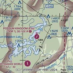
| Sectional chart |
|---|
|
| Airport distance calculator |
|---|
|
|
| Sunrise and sunset |
|---|
|
Times for 03-Jun-2026
| | Local
(UTC-5) | | Zulu
(UTC) |
|---|
| Morning civil twilight | | 05:58 | | 10:58 |
| Sunrise | | 06:27 | | 11:27 |
| Sunset | | 20:37 | | 01:37 |
| Evening civil twilight | | 21:05 | | 02:05 |
|
| Current date and time |
|---|
| Zulu (UTC) | 03-Jun-2026 15:12:29 |
|---|
| Local (UTC-5) | 03-Jun-2026 10:12:29 |
|---|
|
| METAR |
|---|
KRPH
13nm NW | 031455Z AUTO VRB04KT 10SM FEW017 25/20 A3013 RMK AO2 T02470201 50009 $
|
KMWL
20nm SE | 031453Z AUTO 22004KT 10SM CLR 26/19 A3013 RMK AO2 SLP192 T02610189 51008
|
|
| NOTAMs |
|---|
NOTAMs are issued by the DoD/FAA and will open in a separate window not controlled by AirNav.
|
|


