FAA INFORMATION EFFECTIVE 14 MAY 2026
Location
| FAA Identifier: | F47 |
| Lat/Long: | 29-38-40.5025N 084-54-56.1562W
29-38.675042N 084-54.935937W
29.6445840,-84.9155989
(estimated) |
| Elevation: | 3 ft. / 1 m (estimated) |
| Variation: | 01W (1985) |
| From city: | 8 miles SE of APALACHICOLA, FL |
| Time zone: | UTC -4 (UTC -5 during Standard Time) |
| Zip code: | 32328 |
Airport Operations
| Airport use: | Open to the public |
| Activation date: | 03/1983 |
| Control tower: | no |
| ARTCC: | JACKSONVILLE CENTER |
| FSS: | GAINESVILLE FLIGHT SERVICE STATION |
| NOTAMs facility: | GNV (NOTAM-D service available) |
| Attendance: | UNATNDD |
| Wind indicator: | yes |
| Segmented circle: | no |
| Landing fee: | yes |
Airport Communications
| CTAF: | 122.9 |
| WX ASOS at AAF (8 nm NW): | 119.925 (850-203-0001) |
Airport Services
Runway Information
Runway 14/32
| Dimensions: | 3339 x 65 ft. / 1018 x 20 m |
| Surface: | asphalt, in fair condition |
| RUNWAY 14 | | RUNWAY 32 |
| Latitude: | 29-38.871167N | | 29-38.478915N |
| Longitude: | 084-55.157333W | | 084-54.714538W |
| Traffic pattern: | left | | left |
| Runway heading: | 136 magnetic, 135 true | | 316 magnetic, 315 true |
| Markings: | basic, in fair condition | | basic, in fair condition |
| Obstructions: | none
BRUSH 90 FT RIGHT OF CNTRLN, 290 FT AFT THE APCH END OF RWY 14. | | 11 ft. brush, 245 ft. from runway, 90 ft. right of centerline, 4:1 slope to clear
TREES 120 FT RIGHT OF CNTRLN, 200 FT BFR THE APCH END OF RWY 32. |
Airport Ownership and Management from official FAA records
| Ownership: | Privately-owned |
| Owner: | ST GEORGE PLANTATION OWNERS ASSO.
1712 MAGNOLIA ROAD
ST GEORGE ISLAND, FL 32328
Phone 850-927-2312 |
| Manager: | BRENDA ASH
1712 MAGNOLIA ROAD
ST GEORGE ISLAND, FL 32328
Phone 850-927-2312 |
Additional Remarks
| - | GROUND ACCESS BY PERMISSION ONLY. |
| - | LARGE BIRDS ON AND INVOF RY. |
| - | TREES, BRUSH AND BERM, 95-124 FT EAST OF RY CNTRLN RY 32. |
| - | 5 FT BERM, FIRST 1250 FT, 100 FT WEST OF CNTRLN RY 14. |
| - | RY AND RAMP ARE OPEN FOR PUB USE. ALL OTHER SURROUNDING GROUNDS ARE PVT. ACCESS TO ALL AREAS EXCEPT THE RY AND RAMP RQR AN OWNER WI THE PROPERTY ASSOCIATION. |
| - | FOR CD CTC TYNDALL APCH AT 850-283-2900 OR 850-283-3353, WHEN APCH CLSD CTC JACKSONVILLE ARTCC AT 904-845-1592. |
Instrument Procedures
There are no published instrument procedures at F47.
Some nearby airports with instrument procedures:
KAAF - Apalachicola Regional Airport-Cleve Randolph Field (8 nm NW)
KPAM - Tyndall Air Force Base (43 nm NW)
KTLH - Tallahassee International Airport (54 nm NE)
2J9 - Quincy Municipal Airport (60 nm N)
KECP - Northwest Florida Beaches International Airport (63 nm NW)
|
|

Road maps at:
MapQuest
Bing
Google
| Aerial photo |
|---|
WARNING: Photo may not be current or correct
 Photo by Isaac Lang
Photo taken 05-Feb-2018
looking northwest.
Photo by Isaac Lang
Photo taken 05-Feb-2018
looking northwest.
Do you have a better or more recent aerial photo of St George Island Airport that you would like to share? If so, please send us your photo.
|
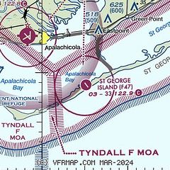
| Sectional chart |
|---|
|
| Airport distance calculator |
|---|
|
|
| Sunrise and sunset |
|---|
|
Times for 06-Jun-2026
| | Local
(UTC-4) | | Zulu
(UTC) |
|---|
| Morning civil twilight | | 06:13 | | 10:13 |
| Sunrise | | 06:40 | | 10:40 |
| Sunset | | 20:37 | | 00:37 |
| Evening civil twilight | | 21:04 | | 01:04 |
|
| Current date and time |
|---|
| Zulu (UTC) | 06-Jun-2026 13:34:29 |
|---|
| Local (UTC-4) | 06-Jun-2026 09:34:29 |
|---|
|
| METAR |
|---|
KAAF
8nm NW | 061253Z AUTO 15009KT 10SM BKN050 27/22 A3005 RMK AO1 SLP176 T02670217 $
|
|
| TAF |
|---|
KPAM
42nm NW | 061100Z 0611/0717 13012KT 9999 SCT020 SCT060 QNH3000INS BECMG 0614/0616 17010G18KT 9999 SCT020 BKN050 QNH2996INS BECMG 0710/0712 15010G15KT 9999 FEW030 SCT050 QNH2999INS TX30/0620Z TN22/0612Z
|
|
| NOTAMs |
|---|
NOTAMs are issued by the DoD/FAA and will open in a separate window not controlled by AirNav.
|
|


