FAA INFORMATION EFFECTIVE 16 APRIL 2026
Location
| FAA Identifier: | FIT |
| Lat/Long: | 42-33-13.8500N 071-45-33.0260W
42-33.230833N 071-45.550433W
42.5538472,-71.7591739
(estimated) |
| Elevation: | 344.5 ft. / 105.0 m (surveyed) |
| Variation: | 15W (2005) |
| From city: | 3 miles SE of FITCHBURG, MA |
| Time zone: | UTC -4 (UTC -5 during Standard Time) |
| Zip code: | 01453 |
Airport Operations
| Airport use: | Open to the public |
| Activation date: | 04/1940 |
| Control tower: | no |
| ARTCC: | BOSTON CENTER |
| FSS: | BRIDGEPORT FLIGHT SERVICE STATION |
| NOTAMs facility: | FIT (NOTAM-D service available) |
| Attendance: | 0800-1700 |
| Pattern altitude: | 1346.5 ft. MSL |
| Wind indicator: | yes |
| Segmented circle: | yes |
| Lights: | ACTVT REIL RWY 14 & 32; PAPI RWY 14 & 32; MIRL RWY 14/32 - 123.0. |
| Beacon: | white-green (lighted land airport)
ROTG BCN NOT AVBL DURG DALGT IFR CONDS. Operates sunset to sunrise. |
| Landing fee: | yes, CORPORATE & COML FLTS ONLY. |
Airport Communications
| CTAF/UNICOM: | 122.7 |
| WX ASOS: | 135.175 (978-343-9121) |
| BOSTON APPROACH: | 124.4 |
| BOSTON DEPARTURE: | 124.4 |
| WX AWOS-3PT at ASH (17 nm NE): | 125.1 (603-578-0473) |
| WX ASOS at ORH (18 nm S): | PHONE 508-767-5851 |
| WX ASOS at AFN (19 nm NW): | 135.875 (603-532-6195) |
Nearby radio navigation aids
| VOR radial/distance | | VOR name | | Freq | | Var |
|---|
| GDMr102/13.2 | | GARDNER VOR/DME | | 116.95 | | 14W |
| BOSr305/36.0 | | BOSTON VOR/DME | | 112.70 | | 16W |
| PUTr020/36.1 | | PUTNAM VOR/DME | | 117.40 | | 14W |
Airport Services
| Fuel available: | 100LL JET-A JET-A+ |
| Parking: | hangars and tiedowns |
| Airframe service: | MAJOR |
| Powerplant service: | MAJOR |
| Bottled oxygen: | NONE |
| Bulk oxygen: | NONE |
Runway Information
Runway 14/32
| Dimensions: | 5001 x 100 ft. / 1524 x 30 m |
| Surface: | asphalt/grooved, in excellent condition |
| Weight bearing capacity: | | Single wheel: | 30.0 | | Double wheel: | 41.0 |
|
| Runway edge lights: | medium intensity |
| RUNWAY 14 | | RUNWAY 32 |
| Latitude: | 42-33.495735N | | 42-32.965892N |
| Longitude: | 071-45.976670W | | 071-45.124270W |
| Elevation: | 344.5 ft. | | 328.5 ft. |
| Traffic pattern: | left | | left |
| Runway heading: | 145 magnetic, 130 true | | 325 magnetic, 310 true |
| Displaced threshold: | 163 ft. | | 300 ft. |
| Declared distances: | TORA:5001 TODA:5001 ASDA:4701 LDA:4538 | | TORA:5001 TODA:5001 ASDA:4838 LDA:4538 |
| Markings: | nonprecision, in good condition | | nonprecision, in good condition |
| Visual slope indicator: | 4-light PAPI on left (3.00 degrees glide path)
PAPI UNUSBL BYD 5 DEGS L & R OF CNTRLN. | | 4-light PAPI on left (3.50 degrees glide path) |
| Runway end identifier lights: | yes | | yes |
| Touchdown point: | yes, no lights | | yes, no lights |
| Obstructions: | 50 ft. trees, 600 ft. from runway, 125 ft. left of centerline, 8:1 slope to clear | | 42 ft. trees, 800 ft. from runway, 125 ft. right of centerline, 14:1 slope to clear |
Airport Ownership and Management from official FAA records
| Ownership: | Publicly-owned |
| Owner: | CITY OF FITCHBURG
CITY HALL, 718 MAIN ST
FITCHBURG, MA 01420
Phone 978-829-1800 |
| Manager: | RUSSEL CORNELIA
FITCHBURG MUNICIPAL AIRPORT, 567 CRAWFORD ST
FITCHBURG, MA 01420
Phone 618-681-1771
PKETTLE@FITCHBURGMA.GOV. |
Additional Remarks
| - | WILDLIFE ON & INVOF ARPT. |
| - | FOR CD CTC BOSTON APCH AT 603-594-5552. |
| - | COLD TEMPERATURE AIRPORT. ALTITUDE CORRECTION REQUIRED AT OR BELOW -21C. |
| - | NOISE SENSITIVE AREA: DEP ACFT CLIMB TO TPA BFR TURNING CROSSWIND. |
Instrument Procedures
NOTE: All procedures below are presented as PDF files. If you need a reader for these files, you should download the free Adobe Reader.NOT FOR NAVIGATION. Please procure official charts for flight.
FAA instrument procedures published for use from 16 April 2026 at 0901Z to 14 May 2026 at 0900Z.
IAPs - Instrument Approach Procedures |
|---|
| RNAV (GPS) RWY 14 | |
download (238KB) |
| RNAV (GPS) RWY 32 | |
download (242KB) |
| NOTE: Special Alternate Minimums apply | |
download (138KB) |
| NOTE: Special Take-Off Minimums/Departure Procedures apply | |
download (533KB) |
Other nearby airports with instrument procedures:
KGDM - Gardner Municipal Airport (11 nm W)
6B6 - Minute Man Air Field (12 nm SE)
KASH - Boire Field Airport (17 nm NE)
KORH - Worcester Regional Airport (18 nm S)
KAFN - Jaffrey Airfield Silver Ranch (19 nm NW)
|
|

Road maps at:
MapQuest
Bing
Google
| Aerial photo |
|---|
WARNING: Photo may not be current or correct
 Photo by Barry Turner
Photo taken 01-Oct-2017
looking west.
Photo by Barry Turner
Photo taken 01-Oct-2017
looking west.
Do you have a better or more recent aerial photo of Fitchburg Municipal Airport that you would like to share? If so, please send us your photo.
|
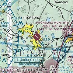
| Sectional chart |
|---|
|
| Airport distance calculator |
|---|
|
|
| Sunrise and sunset |
|---|
|
Times for 07-May-2026
| | Local
(UTC-4) | | Zulu
(UTC) |
|---|
| Morning civil twilight | | 05:04 | | 09:04 |
| Sunrise | | 05:35 | | 09:35 |
| Sunset | | 19:52 | | 23:52 |
| Evening civil twilight | | 20:24 | | 00:24 |
|
| Current date and time |
|---|
| Zulu (UTC) | 07-May-2026 21:26:02 |
|---|
| Local (UTC-4) | 07-May-2026 17:26:02 |
|---|
|
| METAR |
|---|
| KFIT | 072052Z AUTO 31015G22KT 10SM SCT080 16/M03 A2971 RMK AO2 SLP061 T01611033 56011
|
KASH
17nm NE | 072056Z 28011G18KT 10SM SCT080 17/M03 A2970 RMK AO2 SLP055 T01671033 56010
|
KORH
18nm S | 072054Z 28016G24KT 10SM CLR 14/M03 A2971 RMK AO2 PK WND 30026/2011 SLP064 T01391033 55008 $
|
KAFN
18nm NW | 072052Z AUTO 26010G20KT 10SM SCT070 13/M03 A2972 RMK AO2 SLP071 T01331033 56009
|
|
| TAF |
|---|
KORH
18nm S | 071720Z 0718/0818 30012G24KT P6SM FEW050 FM072300 29008KT P6SM SCT120 FM080500 29008KT P6SM FEW090 FM081100 28010KT P6SM FEW200 FM081400 28011G20KT P6SM FEW050
|
KBED
21nm E | 071720Z 0718/0818 29011G21KT P6SM SCT060 FM072300 29007KT P6SM SCT120 FM080700 00000KT P6SM SCT080 FM081400 27010KT P6SM SCT070
|
|
| NOTAMs |
|---|
NOTAMs are issued by the DoD/FAA and will open in a separate window not controlled by AirNav.
|
|


