FAA INFORMATION EFFECTIVE 14 MAY 2026
Location
| FAA Identifier: | FPR |
| Lat/Long: | 27-29-50.9000N 080-22-21.5000W
27-29.848333N 080-22.358333W
27.4974722,-80.3726389
(estimated) |
| Elevation: | 23.4 ft. / 7.1 m (surveyed) |
| Variation: | 07W (2015) |
| From city: | 3 miles NW of FORT PIERCE, FL |
| Time zone: | UTC -4 (UTC -5 during Standard Time) |
| Zip code: | 34946 |
Airport Operations
| Airport use: | Open to the public |
| Control tower: | yes |
| ARTCC: | MIAMI CENTER |
| FSS: | MIAMI FLIGHT SERVICE STATION |
| NOTAMs facility: | FPR (NOTAM-D service available) |
| Attendance: | 0700-2100 |
| Wind indicator: | lighted |
| Segmented circle: | yes |
| Lights: | ACTVT REIL RWY 10R & 28L; MIRL RWY 10L/28R, 10R/28L & 14/32 - CTAF. |
| Beacon: | white-green (lighted land airport)
Operates sunset to sunrise. |
| Fire and rescue: | ARFF index B |
| International operations: | customs landing rights airport |
Airport Communications
| CTAF: | 128.2 |
| ATIS: | 134.825 |
| WX ASOS: | PHONE 772-489-4281 |
| FT PIERCE GROUND: | 119.55 [0700-2100] |
| FT PIERCE TOWER: | 128.2 [0700-2100] |
| PALM BEACH APPROACH: | 132.8 ;SOUTH |
| PALM BEACH DEPARTURE: | 132.8 ;SOUTH |
| WX ASOS at VRB (10 nm N): | 120.575 (772-978-9535) |
Nearby radio navigation aids
| VOR radial/distance | | VOR name | | Freq | | Var |
|---|
| MLBr166/39.0 | | MELBOURNE VOR/DME | | 115.85 | | 07W |
| NDB name | | Hdg/Dist | | Freq | | Var | | ID |
|---|
| UNITED | | 002/35.4 | | 405 | | 05W | | UTX | ..- - -..- |
Airport Services
| Fuel available: | 100LL JET-A
100LL:100LL SELF SERVE |
| Parking: | hangars and tiedowns |
| Airframe service: | MAJOR |
| Powerplant service: | MAJOR |
| Bottled oxygen: | NONE |
| Bulk oxygen: | HIGH/LOW |
Runway Information
Runway 10R/28L
| Dimensions: | 6492 x 150 ft. / 1979 x 46 m
25' PAVED SHOULDERS. |
| Surface: | asphalt, in fair condition |
| Weight bearing capacity: | | Single wheel: | 50.0 | | Double wheel: | 110.0 | | Double tandem: | 230.0 |
|
| Runway edge lights: | medium intensity |
| RUNWAY 10R | | RUNWAY 28L |
| Latitude: | 27-29.835273N | | 27-29.826532N |
| Longitude: | 080-22.762568W | | 080-21.561082W |
| Elevation: | 23.0 ft. | | 21.1 ft. |
| Traffic pattern: | right | | left |
| Runway heading: | 097 magnetic, 090 true | | 277 magnetic, 270 true |
| Declared distances: | TORA:6492 TODA:6492 ASDA:6483 LDA:6483 | | TORA:6492 TODA:6492 ASDA:6434 LDA:6434 |
| Markings: | precision, in good condition | | precision, in good condition |
| Visual slope indicator: | 4-light PAPI on left (3.00 degrees glide path) | | 4-light PAPI on left (3.00 degrees glide path) |
| Runway end identifier lights: | yes | | yes |
| Touchdown point: | yes, no lights | | yes, no lights |
| Instrument approach: | ILS/DME | | |
| Obstructions: | 26 ft. trees, 1380 ft. from runway, 555 ft. left of centerline, 45:1 slope to clear
RWY 10R APCH SLP 50:1 TO AER. | | 35 ft. trees, 1160 ft. from runway, 400 ft. right of centerline, 27:1 slope to clear
RWY 28L APCH SLP 34:1 TO AER. |
Runway 14/32
| Dimensions: | 4755 x 100 ft. / 1449 x 30 m
50' PAVED SHOULDERS. |
| Surface: | asphalt, in excellent condition |
| Weight bearing capacity: | |
| Runway edge lights: | medium intensity |
| RUNWAY 14 | | RUNWAY 32 |
| Latitude: | 27-29.808310N | | 27-29.248938N |
| Longitude: | 080-22.315242W | | 080-21.698038W |
| Elevation: | 22.5 ft. | | 22.9 ft. |
| Traffic pattern: | right | | left |
| Runway heading: | 142 magnetic, 135 true | | 322 magnetic, 315 true |
| Markings: | nonprecision, in good condition | | nonprecision, in good condition |
| Visual slope indicator: | 4-light PAPI on left (3.00 degrees glide path) | | |
| Touchdown point: | yes, no lights | | yes, no lights |
| Obstructions: | 32 ft. trees, 1335 ft. from runway, 260 ft. right of centerline, 35:1 slope to clear | | 43 ft. trees, 1690 ft. from runway, 220 ft. left of centerline, 34:1 slope to clear |
Runway 10L/28R
| Dimensions: | 4000 x 75 ft. / 1219 x 23 m |
| Surface: | asphalt, in good condition |
| Weight bearing capacity: | |
| Runway edge lights: | medium intensity |
| RUNWAY 10L | | RUNWAY 28R |
| Latitude: | 27-30.261195N | | 27-30.255867N |
| Longitude: | 080-23.463908W | | 080-22.723585W |
| Elevation: | 22.9 ft. | | 23.0 ft. |
| Traffic pattern: | left | | right |
| Runway heading: | 097 magnetic, 090 true | | 277 magnetic, 270 true |
| Markings: | basic, in good condition | | basic, in good condition |
| Touchdown point: | yes, no lights | | yes, no lights |
| Obstructions: | 78 ft. pline, 1765 ft. from runway, 20:1 slope to clear | | 40 ft. trees, 840 ft. from runway, 105 ft. left of centerline, 16:1 slope to clear
RWY 28R APCH SLP 21:1 TO AER. |
Airport Ownership and Management from official FAA records
| Ownership: | Publicly-owned |
| Owner: | ST. LUCIE COUNTY
2300 VIRGINIA AVE
FT PIERCE, FL 34982-5652
Phone 772-462-1732 |
| Manager: | CAMERON HOWARD
3000 CURTIS KING BOULEVARD
FT PIERCE, FL 34946
Phone 772-462-1727 |
Additional Remarks
| A39-10L/28R | PCR VALUE: 130/F/A/Y/T |
| A39-14/32 | PCR VALUE: 620/F/A/X/T |
| A39-10R/28L | PCR VALUE: 310/F/A/X/T |
| - | 8 FT FENCE 400 FT FM CNTRLN ON NORTH SIDE OF RWY 10R/28L AND EAST OF RWY 14/32. |
| - | VOLUNTARY NOISE ABATEMENT PROCS IN EFCT, CTC ARPT MGMT AT 772-462-1732. |
| - | LGTD ARFF COM ANT 125 FT AGL (149 FT AMSL) LCTD 793 FT SSE OF RWY 27 THLD. |
| - | RWY 10L/28R VFR TRNG RWY. |
| - | HIGH TENSION PLINES 1/4 SM 'W' AER 10L UNMKD & UNLIGHTED. |
| - | DRAINAGE CHANNEL 80 FT WIDE, 10 FT DEEP, 600 FT FM AER 10L. |
| - | DRAINAGE CHANNEL 80 FT WIDE, 10 FT DEEP 530 FT AER 28R. 2 FT DRAINAGE DITCH 361 FT FR RY 10R THLD 259 FT RIGHT. |
| - | 2 FT DRAINAGE DITCH 797 FT FM THR RWY 28L 349 FT LEFT. |
| - | 2 FT DRAINAGE DITCH 367 FT 'W' OF TWY 'A1' BTWN TWY 'A' & RWY 10L/28R. |
| - | FOR CD, IF UNA VIA GCO, CTC PALM BEACH APCH AT 561-684-9047 OR 561-275-1430. |
| - | GCO AVBL ON FREQ 119.55 PALM BEACH CD. |
| - | EXTENSIVE FLIGHT TRAINING ON AND WITHIN 20 MILES OF ARPT BLO 6000 FT. VFR TRAINING ACFT OUTSIDE OF CLASS D AIRSPACE TRANSMIT INTENDED ACTIVITY ON 123.3. |
| - | NUMEROUS FLOCKS OF BIRDS & WILDLIFE ON AND INVOF ARPT. |
| - | TWY C1 RESTRICTED TO ACFT WITH A WING SPAN OF 105 FT OR LESS. |
Instrument Procedures
NOTE: All procedures below are presented as PDF files. If you need a reader for these files, you should download the free Adobe Reader.NOT FOR NAVIGATION. Please procure official charts for flight.
FAA instrument procedures published for use from 14 May 2026 at 0901Z to 11 June 2026 at 0900z.
IAPs - Instrument Approach Procedures |
|---|
| ILS OR LOC RWY 10R | |
download (239KB) |
| RNAV (GPS) RWY 10R | |
download (235KB) |
| RNAV (GPS) RWY 14 | |
download (265KB) |
| RNAV (GPS) RWY 28L | |
download (208KB) |
| RNAV (GPS) RWY 32 | |
download (284KB) |
| NOTE: Special Alternate Minimums apply | |
download (147KB) |
| NOTE: Special Take-Off Minimums/Departure Procedures apply | |
download (238KB) |
Other nearby airports with instrument procedures:
KVRB - Vero Beach Regional Airport (10 nm N)
X26 - Sebastian Municipal Airport (20 nm N)
KSUA - Witham Field Airport (21 nm SE)
KOBE - Okeechobee County Airport (29 nm SW)
X59 - Valkaria Airport (30 nm N)
|
|

Road maps at:
MapQuest
Bing
Google
| Aerial photo |
|---|
WARNING: Photo may not be current or correct
 Photo by 1st Lt Steven W. Pruitt
Photo taken 04-Dec-2009
looking east.
Photo by 1st Lt Steven W. Pruitt
Photo taken 04-Dec-2009
looking east.
Do you have a better or more recent aerial photo of Treasure Coast International Airport that you would like to share? If so, please send us your photo.
|
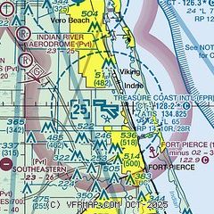
| Sectional chart |
|---|
|
CAUTION: Diagram may not be current
 Download PDF
of official airport diagram from the FAA
| Airport distance calculator |
|---|
|
|
| Sunrise and sunset |
|---|
|
Times for 15-May-2026
| | Local
(UTC-4) | | Zulu
(UTC) |
|---|
| Morning civil twilight | | 06:08 | | 10:08 |
| Sunrise | | 06:34 | | 10:34 |
| Sunset | | 20:02 | | 00:02 |
| Evening civil twilight | | 20:27 | | 00:27 |
|
| Current date and time |
|---|
| Zulu (UTC) | 15-May-2026 11:41:44 |
|---|
| Local (UTC-4) | 15-May-2026 07:41:44 |
|---|
|
| METAR |
|---|
| KFPR | 151053Z AUTO 00000KT 10SM SCT027 OVC060 23/22 A2997 RMK AO2 SLP148 T02280222
|
KVRB
9nm N | 151053Z 00000KT 10SM -RA BKN041 BKN050 OVC065 23/22 A2998 RMK AO2 RAE09B45 SLP151 P0003 T02330222
|
|
| TAF |
|---|
| KFPR | 151002Z 1510/1606 VRB03KT P6SM VCSH FEW035 BKN060 OVC080 FM151400 08008KT P6SM FEW025 SCT040 FM151900 11012G18KT P6SM SCT060 FM160000 12009KT P6SM SCT060
|
KVRB
9nm N | 141732Z 1418/1518 03010KT P6SM SCT035 SCT060 FM142000 05010KT P6SM SCT060 FM142230 08009KT P6SM FEW060 FM150100 VRB04KT P6SM FEW060 FM151500 08011KT P6SM FEW030 FEW060 FEW250
|
|
| NOTAMs |
|---|
NOTAMs are issued by the DoD/FAA and will open in a separate window not controlled by AirNav.
|
|


