FAA INFORMATION EFFECTIVE 16 APRIL 2026
Location
| FAA Identifier: | G05 |
| Lat/Long: | 40-14-43.6200N 080-00-35.3300W
40-14.727000N 080-00.588833W
40.2454500,-80.0098139
(estimated) |
| Elevation: | 1236 ft. / 377 m (estimated) |
| Variation: | 07W (1985) |
| From city: | 1 mile SW of FINLEYVILLE, PA |
| Time zone: | UTC -4 (UTC -5 during Standard Time) |
| Zip code: | 15332 |
Airport Operations
| Airport use: | Open to the public |
| Activation date: | 10/1947 |
| Control tower: | no |
| ARTCC: | CLEVELAND CENTER |
| FSS: | ALTOONA FLIGHT SERVICE STATION |
| NOTAMs facility: | AOO (NOTAM-D service available) |
| Attendance: | IREG |
| Pattern altitude: | TPA ULTRALIGHTS 500 FT AGL. |
| Wind indicator: | lighted |
| Segmented circle: | no |
| Lights: | ACTVT LIRL - CTAF. |
| Beacon: | white-green (lighted land airport)
DUSK - AFT 0000 ACTVT ROTG BCN - CTAF |
Airport Communications
| CTAF/UNICOM: | 123.0 |
| PITTSBURGH APPROACH: | 119.35 |
| PITTSBURGH DEPARTURE: | 119.35 |
| CLASS B: | 119.35 |
| WX ASOS at AGC (8 nm NE): | 120.55 (412-466-8968) |
| WX AWOS-3PT at FWQ (8 nm E): | 118.475 (724-379-5815) |
| WX AWOS-A at 42PN (13 nm N): | PHONE 412-442-2213 |
| WX AWOS-3PT at AFJ (14 nm SW): | 119.175 (724-228-3529) |
| WX ASOS at PIT (18 nm NW): | PHONE 215-798-0218 |
Nearby radio navigation aids
| VOR radial/distance | | VOR name | | Freq | | Var |
|---|
| AGCr153/2.4 | | ALLEGHENY VOR/DME | | 110.00 | | 09W |
| HLGr099/25.6 | | WHEELING VOR/DME | | 114.25 | | 07W |
| EWCr173/36.0 | | ELLWOOD CITY VOR/DME | | 115.80 | | 08W |
| AIRr077/39.5 | | BELLAIRE VOR/DME | | 117.10 | | 07W |
Airport Services
| Fuel available: | 100LL |
| Parking: | hangars and tiedowns |
| Airframe service: | MAJOR |
| Powerplant service: | MAJOR |
| Bottled oxygen: | NONE |
| Bulk oxygen: | NONE |
Runway Information
Runway 14/32
| Dimensions: | 2497 x 50 ft. / 761 x 15 m |
| Surface: | asphalt, in good condition |
| Runway edge lights: | low intensity |
| RUNWAY 14 | | RUNWAY 32 |
| Latitude: | 40-14.862000N | | 40-14.591833N |
| Longitude: | 080-00.791167W | | 080-00.386500W |
| Elevation: | 1236.0 ft. | | 1205.2 ft. |
| Traffic pattern: | left
RWY 14/32 ULTRALIGHTS FLY R TFC. | | left |
| Runway heading: | 138 magnetic, 131 true | | 318 magnetic, 311 true |
| Markings: | basic, in fair condition | | basic, in fair condition |
| Touchdown point: | yes, no lights | | yes, no lights |
| Obstructions: | none
CONTROLLING OBSTN GAS WELL 31 FT HIGH. | | 31 ft. other, lighted, 743 ft. from runway, 38 ft. right of centerline, 17:1 slope to clear |
Airport Ownership and Management from official FAA records
| Ownership: | Privately-owned |
| Owner: | FINLEYVILLE AIRPORT, INC
P.O. BOX 231
FINLEYVILLE, PA 15332
Phone 724-348-7202 |
| Manager: | BOB USNICK
PO BOX 231
FINLEYVILLE, PA 15332
Phone (412) 580-8932 |
Additional Remarks
| - | TRRN FALLS OFF RAPIDLY OFF AER 14; TRRN RISES OFF AER 32. |
| - | PARTIAL PARL TWY MKD WITH REFLECTORS. |
| - | RWY 14/32 ENDS NOT MUTUALLY VSB. |
| - | TRANSIENT PILOTS ADVISED TO CHECK RY COND PRIOR TO USE DURG WINTER MONTHS. |
| - | DEER ON & INVOF RY. |
| - | ULTRALIGHTS AVOID OVERFLYING HOUSES NORTHEAST OF ARPT. |
| - | HEL FOLLOW FIXED WING TFC PAT. |
| - | NO ACFT PRKG ON SE PORTION OF PARL TWY NEXT TO HANGARS 16, 17 & 18. |
| - | LMTD SIGHT DIST DOWN RWY DUE TO HUMP NEAR APP END RWY 14. |
| - | FOR CD CTC PITTSBURGH APCH AT 412-472-5591 |
Instrument Procedures
NOTE: All procedures below are presented as PDF files. If you need a reader for these files, you should download the free Adobe Reader.NOT FOR NAVIGATION. Please procure official charts for flight.
FAA instrument procedures published for use from 16 April 2026 at 0901Z to 14 May 2026 at 0900Z.
IAPs - Instrument Approach Procedures |
|---|
| RNAV (GPS)-A | |
download (186KB) |
| NOTE: Special Take-Off Minimums/Departure Procedures apply | |
download (932KB) |
Other nearby airports with instrument procedures:
KAGC - Allegheny County Airport (8 nm NE)
KFWQ - Rostraver Airport (8 nm E)
KAFJ - Washington County Airport (14 nm SW)
KPIT - Pittsburgh International Airport (18 nm NW)
KWAY - Greene County Airport (21 nm S)
|
|

Road maps at:
MapQuest
Bing
Google
| Aerial photo |
|---|
WARNING: Photo may not be current or correct
 Photo by A. Mattucci www.avphotographics.com
Photo taken 10-Jun-2007
Photo by A. Mattucci www.avphotographics.com
Photo taken 10-Jun-2007
Do you have a better or more recent aerial photo of Finleyville Airpark that you would like to share? If so, please send us your photo.
|
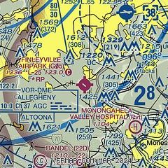
| Sectional chart |
|---|
|
| Airport distance calculator |
|---|
|
|
| Sunrise and sunset |
|---|
|
Times for 12-May-2026
| | Local
(UTC-4) | | Zulu
(UTC) |
|---|
| Morning civil twilight | | 05:38 | | 09:38 |
| Sunrise | | 06:08 | | 10:08 |
| Sunset | | 20:25 | | 00:25 |
| Evening civil twilight | | 20:55 | | 00:55 |
|
| Current date and time |
|---|
| Zulu (UTC) | 12-May-2026 08:31:52 |
|---|
| Local (UTC-4) | 12-May-2026 04:31:52 |
|---|
|
| METAR |
|---|
KAGC
8nm NE | 120753Z 01003KT 10SM FEW090 06/M03 A3019 RMK AO2 SLP230 T00611028
|
KP53
8nm E | 120756Z AUTO 19008KT 02/M04 A3011 RMK AO1 SLP202 T00171039 $
|
KAFJ
14nm SW | 120756Z AUTO 00000KT 10SM BKN090 04/03 A3022 RMK AO2 SLP236 T00440033 $
|
KPIT
19nm NW | 120751Z 00000KT 10SM BKN090 07/M03 A3020 RMK AO2 SLP234 T00721033
|
|
| TAF |
|---|
KAGC
8nm NE | 120520Z 1206/1306 VRB04KT P6SM SCT100 FM130100 20006KT P6SM BKN120
|
KPIT
19nm NW | 120520Z 1206/1312 VRB04KT P6SM SCT100 FM130100 20006KT P6SM BKN120
|
|
| NOTAMs |
|---|
NOTAMs are issued by the DoD/FAA and will open in a separate window not controlled by AirNav.
|
|

