FAA INFORMATION EFFECTIVE 14 MAY 2026
Location
| FAA Identifier: | AFJ |
| Lat/Long: | 40-08-11.3000N 080-17-24.7000W
40-08.188333N 080-17.411667W
40.1364722,-80.2901944
(estimated) |
| Elevation: | 1183.9 ft. / 360.9 m (surveyed) |
| Variation: | 08W (1990) |
| From city: | 3 miles SW of WASHINGTON, PA |
| Time zone: | UTC -4 (UTC -5 during Standard Time) |
| Zip code: | 15301 |
Airport Operations
| Airport use: | Open to the public |
| Activation date: | 10/1947 |
| Control tower: | no |
| ARTCC: | CLEVELAND CENTER |
| FSS: | ALTOONA FLIGHT SERVICE STATION |
| NOTAMs facility: | AFJ (NOTAM-D service available) |
| Attendance: | MON-FRI 0700-1900, ALL SAT-SUN 0700-1700 |
| Wind indicator: | lighted |
| Segmented circle: | yes |
| Lights: | ACTVT REIL RWY 27; HIRL RWY 09/27 - CTAF. |
| Beacon: | white-green (lighted land airport)
Operates sunset to sunrise. |
Airport Communications
| CTAF/UNICOM: | 122.975 |
| WX AWOS-3PT: | 119.175 (724-228-3529) |
| PITTSBURGH APPROACH: | 119.35 |
| PITTSBURGH DEPARTURE: | 119.35 |
| CLEARANCE DELIVERY: | 127.3 |
| CLASS B: | 119.35 |
| WX ASOS at HLG (16 nm W): | 127.375 (304-277-3504) |
Nearby radio navigation aids
| VOR radial/distance | | VOR name | | Freq | | Var |
|---|
| AGCr242/14.3 | | ALLEGHENY VOR/DME | | 110.00 | | 09W |
| HLGr127/14.8 | | WHEELING VOR/DME | | 114.25 | | 07W |
| AIRr081/25.2 | | BELLAIRE VOR/DME | | 117.10 | | 07W |
| NDB name | | Hdg/Dist | | Freq | | Var | | ID |
|---|
| CADIZ | | 107/33.7 | | 239 | | 07W | | CFX | -.-. ..-. -..- |
Airport Services
| Fuel available: | 100LL JET-A JET-A+ |
| Parking: | hangars and tiedowns |
| Airframe service: | MAJOR |
| Powerplant service: | MAJOR |
| Bottled oxygen: | HIGH |
| Bulk oxygen: | HIGH |
Runway Information
Runway 9/27
| Dimensions: | 5004 x 100 ft. / 1525 x 30 m |
| Surface: | asphalt, in good condition |
| Weight bearing capacity: | | Single wheel: | 40.0 | | Double wheel: | 60.0 | | Double tandem: | 90.0 |
|
| Runway edge lights: | high intensity |
| RUNWAY 9 | | RUNWAY 27 |
| Latitude: | 40-08.153088N | | 40-08.224535N |
| Longitude: | 080-17.946347W | | 080-16.876682W |
| Elevation: | 1177.7 ft. | | 1166.9 ft. |
| Traffic pattern: | left | | left |
| Runway heading: | 093 magnetic, 085 true | | 273 magnetic, 265 true |
| Markings: | nonprecision, in good condition | | precision, in good condition |
| Visual slope indicator: | 4-light PAPI on left (3.71 degrees glide path)
RWY 09 PAPI UNUSBL BYD 7.0 DEGS RIGHT OF CNTRLN. | | 4-light PAPI on left (3.09 degrees glide path) |
| Runway end identifier lights: | | | yes |
| Touchdown point: | yes, no lights | | yes, no lights |
| Instrument approach: | | | ILS/DME |
| Obstructions: | 84 ft. trees, 369 ft. from runway, 466 ft. left of centerline, 2:1 slope to clear | | 46 ft. trees, 1134 ft. from runway, 435 ft. right of centerline, 20:1 slope to clear |
Airport Ownership and Management from official FAA records
| Ownership: | Publicly-owned |
| Owner: | WASHINGTON COUNTY
100 WEST BEAU ST
WASHINGTON, PA 15301
Phone 724-228-6875 |
| Manager: | DANIEL SECRIST
600 AIRPORT RD,
WASHINGTON, PA 15301
Phone 724-228-5151 |
Additional Remarks
| - | BIRDS ON & INVOF RWY. |
| - | 208 FT HILL & TREES 2937 FT FM THR RWY END 09. 226 FT HILL & TREES 2941 FT FM THR RWY END 09. |
| - | 288 FT HILL & TREES 7238 FT FM THR RWY END 27. 268 FT HILL & TREES 8091 FT FM THR RWY END 27. |
| - | 158 FT OBSTR LIT POLE APPROX 3389 FT FM THR RWY END 09. 159 FT OBSTN LIT POLE APPROX 3055 FT FM THR RWY END 09. |
Instrument Procedures
NOTE: All procedures below are presented as PDF files. If you need a reader for these files, you should download the free Adobe Reader.NOT FOR NAVIGATION. Please procure official charts for flight.
FAA instrument procedures published for use from 14 May 2026 at 0901Z to 11 June 2026 at 0900Z.
IAPs - Instrument Approach Procedures |
|---|
| ILS OR LOC RWY 27 **CHANGED** | |
download (217KB) |
| RNAV (GPS) RWY 09 **CHANGED** | |
download (170KB) |
| RNAV (GPS) RWY 27 **CHANGED** | |
download (220KB) |
| NOTE: Special Alternate Minimums apply | |
download (122KB) |
| NOTE: Special Take-Off Minimums/Departure Procedures apply | |
download (435KB) |
Other nearby airports with instrument procedures:
G05 - Finleyville Airpark (14 nm NE)
KWAY - Greene County Airport (16 nm SE)
KHLG - Wheeling Ohio County Airport (16 nm W)
KAGC - Allegheny County Airport (21 nm NE)
KPIT - Pittsburgh International Airport (21 nm N)
|
|

Road maps at:
MapQuest
Bing
Google
| Aerial photo |
|---|
WARNING: Photo may not be current or correct
 Photo by William E. Casciola
Photo taken 16-Jul-2006
looking generally east-northeast
Photo by William E. Casciola
Photo taken 16-Jul-2006
looking generally east-northeast
Do you have a better or more recent aerial photo of Washington County Airport that you would like to share? If so, please send us your photo.
|
| Sectional chart |
|---|
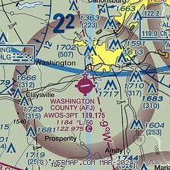
|
CAUTION: Diagram may not be current

| Airport distance calculator |
|---|
|
|
| Sunrise and sunset |
|---|
|
Times for 09-Jun-2026
| | Local
(UTC-4) | | Zulu
(UTC) |
|---|
| Morning civil twilight | | 05:20 | | 09:20 |
| Sunrise | | 05:53 | | 09:53 |
| Sunset | | 20:48 | | 00:48 |
| Evening civil twilight | | 21:21 | | 01:21 |
|
| Current date and time |
|---|
| Zulu (UTC) | 09-Jun-2026 13:49:40 |
|---|
| Local (UTC-4) | 09-Jun-2026 09:49:40 |
|---|
|
| METAR |
|---|
KAFJ
2nm SE | 091256Z AUTO 19005KT 10SM FEW080 24/19 A3019 RMK AO2 SLP214 T02440194 $
|
KHLG
17nm W | 091253Z 21008KT 10SM FEW040 24/19 A3015 RMK AO2 SLP202 T02390189
|
|
| TAF |
|---|
KHLG
17nm W | 091139Z 0912/1012 19005KT P6SM VCSH FEW070 OVC090 PROB30 0920/0924 5SM -TSRA BKN025CB FM100000 19008KT 6SM -TSRA BR SCT022 BKN027CB FM100500 20008KT 6SM -SHRA BR BKN007 BKN015
|
|
| NOTAMs |
|---|
NOTAMs are issued by the DoD/FAA and will open in a separate window not controlled by AirNav.
|
|


