FAA INFORMATION EFFECTIVE 25 DECEMBER 2025
Location
| FAA Identifier: | GAD |
| Lat/Long: | 33-58-13.4590N 086-05-28.6390W
33-58.224317N 086-05.477317W
33.9704053,-86.0912886
(estimated) |
| Elevation: | 569.2 ft. / 173.5 m (surveyed) |
| Variation: | 03W (2010) |
| From city: | 4 miles SW of GADSDEN, AL |
| Time zone: | UTC -6 (UTC -5 during Daylight Saving Time) |
| Zip code: | 35954 |
Airport Operations
| Airport use: | Open to the public |
| Activation date: | 01/1944 |
| Control tower: | no |
| ARTCC: | ATLANTA CENTER |
| FSS: | ANNISTON FLIGHT SERVICE STATION |
| NOTAMs facility: | GAD (NOTAM-D service available) |
| Attendance: | MON-FRI 0800-1800, ALL SAT 0900-1700
FOR AFT HRS SVC CALL 256-328-4700, 256-504-8109, OR 256-458-2736 |
| Wind indicator: | lighted |
| Segmented circle: | yes |
| Lights: | REACTVT REIL RWY 6 & 24; PAPI RWY 6 & 24; HIRL RWY 6/24; TWY LGTS - CTAF. |
| Beacon: | white-green (lighted land airport)
Operates sunset to sunrise. |
Airport Communications
| CTAF/UNICOM: | 122.725 |
| WX AWOS-3PT: | 127.825 (256-442-7094) |
| BIRMINGHAM APPROACH: | 125.45 |
| BIRMINGHAM DEPARTURE: | 125.45 |
| CLEARANCE DELIVERY: | 120.05 |
| WX AWOS-3PT at BFZ (18 nm NW): | 119.575 (256-891-8259) |
Nearby radio navigation aids
| VOR radial/distance | | VOR name | | Freq | | Var |
|---|
| GAD at field | | GADSDEN VOR/DME | | 112.30 | | 02E |
Airport Services
| Fuel available: | 100LL JET-A1+ |
| Parking: | hangars and tiedowns |
| Airframe service: | MAJOR |
| Powerplant service: | MAJOR |
Runway Information
Runway 6/24
| Dimensions: | 6802 x 150 ft. / 2073 x 46 m |
| Surface: | asphalt/grooved, in fair condition |
| Weight bearing capacity: | | Single wheel: | 90.0 | | Double wheel: | 115.0 | | Double tandem: | 195.0 |
|
| Runway edge lights: | high intensity |
| RUNWAY 6 | | RUNWAY 24 |
| Latitude: | 33-57.950313N | | 33-58.498280N |
| Longitude: | 086-06.064573W | | 086-04.890007W |
| Elevation: | 569.2 ft. | | 549.3 ft. |
| Traffic pattern: | left | | left |
| Runway heading: | 064 magnetic, 061 true | | 244 magnetic, 241 true |
| Markings: | precision, in fair condition | | precision, in fair condition |
| Visual slope indicator: | 4-light PAPI on left (3.00 degrees glide path) | | 4-light PAPI on left (3.00 degrees glide path) |
| Runway end identifier lights: | yes | | yes |
| Touchdown point: | yes, no lights | | yes, no lights |
| Instrument approach: | | | ILS/DME |
| Obstructions: | 52 ft. tree, 1621 ft. from runway, 222 ft. right of centerline, 27:1 slope to clear | | 55 ft. tree, 2724 ft. from runway, 172 ft. left of centerline, 45:1 slope to clear |
Airport Ownership and Management from official FAA records
| Ownership: | Publicly-owned |
| Owner: | GADSDEN AIRPORT AUTHORITY
185 IRA GRAY DR.
GADSDEN, AL 35904
Phone 256-442-3313 |
| Manager: | ANTHONY TARVER
185 IRA GRAY DRIVE
GADSDEN, AL 35904
Phone 256-328-4700 |
Instrument Procedures
NOTE: All procedures below are presented as PDF files. If you need a reader for these files, you should download the free Adobe Reader.NOT FOR NAVIGATION. Please procure official charts for flight.
FAA instrument procedures published for use from 25 December 2025 at 0901z to 22 January 2026 at 0900z.
IAPs - Instrument Approach Procedures |
|---|
| ILS OR LOC RWY 24 | |
download (300KB) |
| RNAV (GPS) RWY 06 | |
download (265KB) |
| RNAV (GPS) RWY 24 | |
download (284KB) |
| VOR RWY 06 | |
download (229KB) |
| NOTE: Special Alternate Minimums apply | |
download (157KB) |
| NOTE: Special Take-Off Minimums/Departure Procedures apply | |
download (522KB) |
Other nearby airports with instrument procedures:
20A - Robbins Field Airport (14 nm W)
KBFZ - Albertville Regional Airport-Thomas J Brumlik Field (18 nm NW)
KASN - Talladega Municipal Airport (24 nm S)
KPYP - Centre Piedmont/Cherokee County Regional Airport (25 nm E)
KANB - Anniston Regional Airport (26 nm SE)
|
|

Road maps at:
MapQuest
Bing
Google
| Aerial photo |
|---|
WARNING: Photo may not be current or correct
 Photo by Marty Sellers sellersphoto.com
Photo taken 22-Sep-2017
looking west.
Photo by Marty Sellers sellersphoto.com
Photo taken 22-Sep-2017
looking west.
Do you have a better or more recent aerial photo of Northeast Alabama Regional Airport that you would like to share? If so, please send us your photo.
|
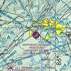
| Sectional chart |
|---|
|
CAUTION: Diagram may not be current

| Airport distance calculator |
|---|
|
|
| Sunrise and sunset |
|---|
|
Times for 07-Jan-2026
| | Local
(UTC-6) | | Zulu
(UTC) |
|---|
| Morning civil twilight | | 06:24 | | 12:24 |
| Sunrise | | 06:52 | | 12:52 |
| Sunset | | 16:50 | | 22:50 |
| Evening civil twilight | | 17:17 | | 23:17 |
|
| Current date and time |
|---|
| Zulu (UTC) | 07-Jan-2026 13:30:03 |
|---|
| Local (UTC-6) | 07-Jan-2026 07:30:03 |
|---|
|
| METAR |
|---|
| KGAD | 071256Z AUTO 00000KT 1/4SM FG OVC003 13/ A2999 RMK AO2 SLP157 T0133 $
|
KBFZ
18nm NW | 071315Z AUTO 21003KT 3/4SM BR OVC008 15/15 A2999 RMK AO2
|
|
| NOTAMs |
|---|
NOTAMs are issued by the DoD/FAA and will open in a separate window not controlled by AirNav.
|
|


