FAA INFORMATION EFFECTIVE 15 MAY 2025
Location
| FAA Identifier: | GDW |
| Lat/Long: | 43-58-14.1220N 084-28-30.0710W
43-58.235367N 084-28.501183W
43.9705894,-84.4750197
(estimated) |
| Elevation: | 774.1 ft. / 235.9 m (surveyed) |
| Variation: | 04W (1980) |
| From city: | 1 mile SE of GLADWIN, MI |
| Time zone: | UTC -4 (UTC -5 during Standard Time) |
| Zip code: | 48624 |
Airport Operations
| Airport use: | Open to the public |
| Activation date: | 04/1940 |
| Control tower: | no |
| ARTCC: | CLEVELAND CENTER |
| FSS: | LANSING FLIGHT SERVICE STATION |
| NOTAMs facility: | LAN (NOTAM-D service available) |
| Attendance: | 0900-1700
UNATNDD MAJOR HOLS. FOR SVC AFT HRS CALL AMGR CELL. |
| Wind indicator: | lighted |
| Segmented circle: | yes |
| Lights: | ACTVT REIL RWY 09 & 27; PAPI RWY 09 & 27; MIRL RWY 09/27 - CTAF. |
| Beacon: | white-green (lighted land airport)
Operates sunset to sunrise. |
Airport Communications
| CTAF/UNICOM: | 122.8 |
| GREAT LAKES APPROACH: | 126.45 |
| GREAT LAKES DEPARTURE: | 126.45 |
- APCH/DEP SVC PRVDD BY CLEVELAND ARTCC (ZOB) ON FREQS 127.7/290.425 (FREELAND RCAG) WHEN GREAT LAKES APCH CTL CLSD.
Nearby radio navigation aids
| VOR radial/distance | | VOR name | | Freq | | Var |
|---|
| MOPr034/23.8 | | MOUNT PLEASANT VOR/DME | | 110.60 | | 05W |
| MBSr330/31.5 | | SAGINAW VOR/DME | | 114.35 | | 03W |
Airport Services
| Fuel available: | 100LL JET-A+
100LL:100LL AVBL H24 SELF SVC VIA CREDIT CARD. JET A+ AVBL FULL SVC DURG BUS HRS OR BY ARNGMT. |
| Parking: | tiedowns |
Runway Information
Runway 9/27
| Dimensions: | 4699 x 75 ft. / 1432 x 23 m |
| Surface: | asphalt, in good condition |
| Weight bearing capacity: | | Single wheel: | 44.0 | | Double wheel: | 60.0 | | Double tandem: | 90.0 |
|
| Runway edge lights: | medium intensity |
| RUNWAY 9 | | RUNWAY 27 |
| Latitude: | 43-58.304540N | | 43-58.335602N |
| Longitude: | 084-28.971940W | | 084-27.901957W |
| Elevation: | 771.3 ft. | | 772.7 ft. |
| Traffic pattern: | left | | left |
| Runway heading: | 092 magnetic, 088 true | | 272 magnetic, 268 true |
| Markings: | nonprecision, in good condition | | nonprecision, in good condition |
| Visual slope indicator: | 4-light PAPI on left (3.75 degrees glide path) | | 4-light PAPI on left (3.00 degrees glide path) |
| Runway end identifier lights: | yes | | yes |
| Touchdown point: | yes, no lights | | yes, no lights |
| Obstructions: | 34 ft. tree, 856 ft. from runway, 343 ft. left of centerline, 19:1 slope to clear | | none |
Runway 15/33
| Dimensions: | 2580 x 150 ft. / 786 x 46 m |
| Surface: | turf, in fair condition |
| Runway edge markings: | 3 FT YELLOW CONES. |
| Operational restrictions: | CLSD WHEN SNOW COVD EXC FOR SKI EQUIPPED ACFT. |
| RUNWAY 15 | | RUNWAY 33 |
| Latitude: | 43-58.276013N | | 43-57.886140N |
| Longitude: | 084-28.734625W | | 084-28.501702W |
| Elevation: | 772.7 ft. | | 764.3 ft. |
| Traffic pattern: | left | | left |
| Runway heading: | 161 magnetic, 157 true | | 341 magnetic, 337 true |
| Touchdown point: | yes, no lights | | yes, no lights |
| Obstructions: | none | | 9 ft. tree, 93 ft. from runway, 133 ft. left of centerline, 10:1 slope to clear |
Airport Ownership and Management from official FAA records
| Ownership: | Publicly-owned |
| Owner: | CITY/CO OF GLADWIN
1000 W CEDAR AVE
GLADWIN, MI 48624-1814
Phone 989-426-9231
CITY HALL. |
| Manager: | MICHAEL HARGRAVE
735 S STATE ST
GLADWIN, MI 48624-2258
Phone 989-426-4201
CELL 989-578-2174. |
Additional Remarks
| - | DEER & LRG BIRDS ON & INVOF ARPT. |
| - | UAS OPR WEST OF RWY 15/33. |
| - | TRML BLDG ACES: 5-3-2-1-*. |
| - | FOR CD CTC GREAT LAKES APCH AT 269-459-3345, WHEN APCH CLSD CTC CLEVELAND ARTCC AT 440-774-0224/0490. |
Instrument Procedures
NOTE: All procedures below are presented as PDF files. If you need a reader for these files, you should download the free Adobe Reader.NOT FOR NAVIGATION. Please procure official charts for flight.
FAA instrument procedures published for use from 15 May 2025 at 0901Z to 13 June 2025 at 0900z.
IAPs - Instrument Approach Procedures |
|---|
| RNAV (GPS) RWY 09 | |
download (211KB) |
| RNAV (GPS) RWY 27 | |
download (225KB) |
| NOTE: Special Take-Off Minimums/Departure Procedures apply | |
download (327KB) |
Other nearby airports with instrument procedures:
48D - Clare Municipal Airport (14 nm SW)
KIKW - Jack Barstow Airport (21 nm SE)
Y31 - West Branch Community Airport (21 nm NE)
KMOP - Mount Pleasant Municipal Airport (24 nm SW)
KHTL - Roscommon County/Blodgett Memorial Airport (25 nm N)
|
|

Road maps at:
MapQuest
Bing
Google
| Aerial photo |
|---|
WARNING: Photo may not be current or correct
 Photo by Carol Batten
Do you have a better or more recent aerial photo of Gladwin Zettel Memorial Airport that you would like to share? If so, please send us your photo.
|
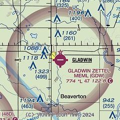
| Sectional chart |
|---|
|
| Airport distance calculator |
|---|
|
|
| Sunrise and sunset |
|---|
|
Times for 18-May-2025
| | Local
(UTC-4) | | Zulu
(UTC) |
|---|
| Morning civil twilight | | 05:36 | | 09:36 |
| Sunrise | | 06:10 | | 10:10 |
| Sunset | | 20:59 | | 00:59 |
| Evening civil twilight | | 21:33 | | 01:33 |
|
| Current date and time |
|---|
| Zulu (UTC) | 18-May-2025 09:24:25 |
|---|
| Local (UTC-4) | 18-May-2025 05:24:25 |
|---|
|
| METAR |
|---|
KY31
21nm NE | 180855Z AUTO 29014G20KT 10SM OVC010 07/07 A2974 RMK AO2 T00700068 PWINO
|
KMOP
24nm SW | 180855Z AUTO 30009KT 10SM OVC016 10/07 A2977 RMK AO2 T00990066
|
KHTL
24nm N | 180853Z AUTO 31013G18KT 10SM OVC005 06/04 A2978 RMK AO2 SLP089 60000 T00560039 51018
|
KMBS
31nm SE | 180900Z 31011G18KT 10SM BKN020 BKN075 OVC100 11/07 A2976 RMK AO2 T01110072
|
KAMN
40nm S | 180855Z AUTO 30009G17KT 10SM 11/08 A2977 RMK AO2 PWINO
|
|
| TAF |
|---|
KMBS
31nm SE | 180520Z 1806/1906 30013G20KT P6SM OVC015 TEMPO 1806/1808 BKN025 OVC040 FM181600 33013KT P6SM BKN025 OVC040 FM181900 36010KT P6SM OVC040 FM182300 04007KT P6SM BKN040
|
|
| NOTAMs |
|---|
NOTAMs are issued by the DoD/FAA and will open in a separate window not controlled by AirNav.
|
|


