FAA INFORMATION EFFECTIVE 14 MAY 2026
Location
| FAA Identifier: | GLR |
| Lat/Long: | 45-00-46.9000N 084-42-12.4000W
45-00.781667N 084-42.206667W
45.0130278,-84.7034444
(estimated) |
| Elevation: | 1328.1 ft. / 404.8 m (surveyed) |
| Variation: | 06W (2000) |
| From city: | 1 mile SW of GAYLORD, MI |
| Time zone: | UTC -4 (UTC -5 during Standard Time) |
| Zip code: | 49735 |
Airport Operations
| Airport use: | Open to the public |
| Activation date: | 08/1945 |
| Control tower: | no |
| ARTCC: | MINNEAPOLIS CENTER |
| FSS: | LANSING FLIGHT SERVICE STATION |
| NOTAMs facility: | GLR (NOTAM-D service available) |
| Attendance: | MAY-OCT 0730-1800, NOV-APR 0630-1700
FOR ATTENDANT AFT HRS CALL AMGR. UNATNDD THANKSGIVING, CHRISTMAS, & NEW YEARS DAY. |
| Wind indicator: | lighted |
| Segmented circle: | yes |
| Lights: | ACTVT MALSR RWY 09; REIL RWY 27, 18, & 36; PAPI RWY 09, 27, 18, & 36; HIRL RWY 09/27; MIRL RWY 18/36 - CTAF. |
| Beacon: | white-green (lighted land airport)
Operates sunset to sunrise. |
| Landing fee: | no, LDG FEE FOR TURBINE, JET, & TWIN-ENG ACFT WAIVED WITH MNM FUEL PURCHASE. OVNGT PRKG FEE. |
Airport Communications
| CTAF/UNICOM: | 122.8 |
| WX ASOS: | 118.375 (989-732-1571) |
| WX AWOS-3PT at BFA (13 nm NW): | 118.675 (231-330-8677) |
| WX ASOS at GOV (20 nm S): | PHONE 989-348-3127 |
- APCH/DEP SVC PRVDD BY MINNEAPOLIS ARTCC ON FREQS 134.6/354.05 (PELLSTON RCAG).
Nearby radio navigation aids
| VOR radial/distance | | VOR name | | Freq | | Var |
|---|
| CGGr009/(19.9) | | GRAYLING VOR | | 109.80 | | 06W |
| PLNr189/37.1 | | PELLSTON VORTAC | | 111.80 | | 06W |
| NDB name | | Hdg/Dist | | Freq | | Var | | ID |
|---|
| BANGU | | 097/4.4 | | 375 | | 06W | | GL | --. .-.. |
| GRAYLING | | 025/16.7 | | 359 | | 06W | | GYG | --. -.-- --. |
Airport Services
| Fuel available: | 100LL JET-A+
100LL:SUBJ AFT HRS CALL-IN FEE. |
| Parking: | hangars and tiedowns |
| Airframe service: | MAJOR |
| Powerplant service: | MAJOR |
| Bottled oxygen: | HIGH/LOW |
Runway Information
Runway 9/27
| Dimensions: | 6579 x 150 ft. / 2005 x 46 m |
| Surface: | asphalt, in good condition |
| Weight bearing capacity: | |
| Runway edge lights: | high intensity |
| RUNWAY 9 | | RUNWAY 27 |
| Latitude: | 45-00.870345N | | 45-00.868253N |
| Longitude: | 084-43.020840W | | 084-41.494650W |
| Elevation: | 1320.6 ft. | | 1328.1 ft. |
| Traffic pattern: | left | | left |
| Runway heading: | 096 magnetic, 090 true | | 276 magnetic, 270 true |
| Markings: | precision, in fair condition | | precision, in fair condition |
| Visual slope indicator: | 4-light PAPI on left (3.00 degrees glide path) | | 4-light PAPI on left (3.00 degrees glide path) |
| Approach lights: | MALSR: 1,400 foot medium intensity approach lighting system with runway alignment indicator lights | | |
| Runway end identifier lights: | | | yes |
| Touchdown point: | yes, no lights | | yes, no lights |
| Instrument approach: | ILS | | |
| Obstructions: | 58 ft. tree, 2040 ft. from runway, 213 ft. left of centerline, 31:1 slope to clear | | 38 ft. pole, 1117 ft. from runway, 278 ft. right of centerline, 24:1 slope to clear |
Runway 18/36
| Dimensions: | 4200 x 75 ft. / 1280 x 23 m |
| Surface: | asphalt, in good condition |
| Weight bearing capacity: | |
| Runway edge lights: | medium intensity |
| RUNWAY 18 | | RUNWAY 36 |
| Latitude: | 45-00.990858N | | 45-00.299783N |
| Longitude: | 084-42.127275W | | 084-42.129162W |
| Elevation: | 1321.9 ft. | | 1316.4 ft. |
| Traffic pattern: | left | | left |
| Runway heading: | 186 magnetic, 180 true | | 006 magnetic, 000 true |
| Markings: | precision, in fair condition | | precision, in fair condition |
| Visual slope indicator: | 4-light PAPI on left (3.00 degrees glide path) | | 4-light PAPI on left (3.00 degrees glide path)
PAPI UNUSBL BYD 8 DEGS LEFT & 7 DEGS RIGHT OF CNTRLN. |
| Runway end identifier lights: | yes | | yes |
| Touchdown point: | yes, no lights | | yes, no lights |
Airport Ownership and Management from official FAA records
| Ownership: | Publicly-owned |
| Owner: | OTSEGO COUNTY
225 W MAIN ST
GAYLORD, MI 49735-1881
Phone 989-731-7520 |
| Manager: | SHARI RIVEST
PO BOX 1396
GAYLORD, MI 49734-5396
Phone 989-732-4218
CELL 989-390-5980. |
Additional Remarks
| - | DEER & BIRDS ON & INVOF ARPT. |
| - | MIL TRG ACT INVOF ARPT ASSOCD WITH R-4201A/B. |
| - | ADMIN BLDG ACES 5-3-2-1. |
| - | FOR CD IF UNA TO CTC ON FSS FREQ, CTC MINNEAPOLIS ARTCC AT 651-463-5588. |
Instrument Procedures
NOTE: All procedures below are presented as PDF files. If you need a reader for these files, you should download the free Adobe Reader.NOT FOR NAVIGATION. Please procure official charts for flight.
FAA instrument procedures published for use from 14 May 2026 at 0901Z to 11 June 2026 at 0900Z.
IAPs - Instrument Approach Procedures |
|---|
| ILS OR LOC RWY 09 **CHANGED** | |
download (260KB) |
| RNAV (GPS) RWY 09 **CHANGED** | |
download (285KB) |
| RNAV (GPS) RWY 27 **CHANGED** | |
download (262KB) |
| NOTE: Special Alternate Minimums apply | |
download (140KB) |
| NOTE: Special Take-Off Minimums/Departure Procedures apply | |
download (371KB) |
Other nearby airports with instrument procedures:
KBFA - Boyne Mountain Airport (13 nm NW)
N98 - Boyne City Municipal Airport (17 nm NW)
KGOV - Grayling Army Airfield (20 nm S)
KACB - Antrim County Airport (21 nm W)
KMGN - Harbor Springs Airport (26 nm N)
|
|

Road maps at:
MapQuest
Bing
Google
| Aerial photo |
|---|
WARNING: Photo may not be current or correct
 looking North
Do you have a better or more recent aerial photo of Gaylord Regional Airport that you would like to share? If so, please send us your photo.
|
| Sectional chart |
|---|
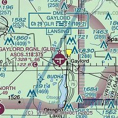
|
CAUTION: Diagram may not be current

| Airport distance calculator |
|---|
|
|
| Sunrise and sunset |
|---|
|
Times for 15-May-2026
| | Local
(UTC-4) | | Zulu
(UTC) |
|---|
| Morning civil twilight | | 05:36 | | 09:36 |
| Sunrise | | 06:11 | | 10:11 |
| Sunset | | 21:00 | | 01:00 |
| Evening civil twilight | | 21:34 | | 01:34 |
|
| Current date and time |
|---|
| Zulu (UTC) | 15-May-2026 17:17:33 |
|---|
| Local (UTC-4) | 15-May-2026 13:17:33 |
|---|
|
| METAR |
|---|
| KGLR | 151653Z AUTO 19011KT 10SM OVC080 15/01 A2991 RMK AO2 SLP134 T01500006
|
KBFA
13nm NW | 151655Z AUTO 18007KT 10SM OVC080 18/02 A2988 RMK AO2
|
KGOV
20nm S | 151555Z AUTO 21007KT 10SM OVC090 15/01 A2993 RMK AO2 SLP146 T01470009 $
|
|
| NOTAMs |
|---|
NOTAMs are issued by the DoD/FAA and will open in a separate window not controlled by AirNav.
|
|


