FAA INFORMATION EFFECTIVE 14 MAY 2026
Location
| FAA Identifier: | GPZ |
| Lat/Long: | 47-12-33.4220N 093-30-35.8010W
47-12.557033N 093-30.596683W
47.2092839,-93.5099447
(estimated) |
| Elevation: | 1355.7 ft. / 413.2 m (surveyed) |
| Variation: | 02E (1995) |
| From city: | 2 miles SE of GRAND RAPIDS, MN |
| Time zone: | UTC -5 (UTC -6 during Standard Time) |
| Zip code: | 55744 |
Airport Operations
| Airport use: | Open to the public |
| Activation date: | 04/1940 |
| Control tower: | no |
| ARTCC: | MINNEAPOLIS CENTER |
| FSS: | PRINCETON FLIGHT SERVICE STATION |
| NOTAMs facility: | GPZ (NOTAM-D service available) |
| Attendance: | APR-OCT 0700-2100, NOV-MAR 0700-2000 |
| Wind indicator: | lighted |
| Segmented circle: | yes |
| Lights: | ACTVT MALSR RWY 34; REIL RWY 05, 16, 23; PAPI RWY 05, 16, 23, 34; MIRL RWY 05/23; HIRL RWY 16/34 - CTAF. |
| Beacon: | white-green (lighted land airport)
Operates sunset to sunrise. |
Airport Communications
| CTAF/UNICOM: | 122.8 |
| WX AWOS-3PT: | 118.425 (218-326-8337) |
- APCH/DEP SVC PRVDD BY MINNEAPOLIS ARTCC ON FREQS 127.9/281.45 (DULUTH RCAG).
Nearby radio navigation aids
| VOR radial/distance | | VOR name | | Freq | | Var |
|---|
| GPZr337/2.9 | | GRAND RAPIDS VOR/DME | | 114.65 | | 06E |
| HIBr258/33.3 | | HIBBING VOR/DME | | 116.55 | | 02E |
Airport Services
| Fuel available: | 100LL JET-A |
| Parking: | hangars and tiedowns |
| Airframe service: | MAJOR |
| Powerplant service: | MAJOR |
| Bottled oxygen: | NONE |
| Bulk oxygen: | LOW |
Runway Information
Runway 16/34
| Dimensions: | 5756 x 100 ft. / 1754 x 30 m
228 FT PAVED AREA AT N END. |
| Surface: | asphalt/porous friction courses, in good condition |
| Weight bearing capacity: | | Single wheel: | 23.0 | | Double wheel: | 38.0 | | Double tandem: | 78.0 |
|
| Runway edge lights: | high intensity |
| RUNWAY 16 | | RUNWAY 34 |
| Latitude: | 47-12.880952N | | 47-11.963830N |
| Longitude: | 093-30.791610W | | 093-30.446365W |
| Elevation: | 1298.1 ft. | | 1355.7 ft. |
| Traffic pattern: | left | | left |
| Runway heading: | 164 magnetic, 166 true | | 344 magnetic, 346 true |
| Markings: | precision, in good condition | | precision, in good condition |
| Visual slope indicator: | 4-light PAPI on right (3.00 degrees glide path) | | 4-light PAPI on left (3.00 degrees glide path) |
| Approach lights: | | | MALSR: 1,400 foot medium intensity approach lighting system with runway alignment indicator lights |
| Runway end identifier lights: | yes | | no |
| Touchdown point: | yes, no lights | | yes, no lights |
| Instrument approach: | | | ILS |
| Obstructions: | none | | 37 ft. brush, 1378 ft. from runway, 562 ft. left of centerline, 31:1 slope to clear |
Runway 5/23
| Dimensions: | 3000 x 60 ft. / 914 x 18 m |
| Surface: | asphalt, in good condition |
| Weight bearing capacity: | |
| Runway edge lights: | medium intensity |
| RUNWAY 5 | | RUNWAY 23 |
| Latitude: | 47-12.648110N | | 47-12.982635N |
| Longitude: | 093-30.820088W | | 093-30.287730W |
| Elevation: | 1302.3 ft. | | 1294.3 ft. |
| Traffic pattern: | left | | left |
| Runway heading: | 045 magnetic, 047 true | | 225 magnetic, 227 true |
| Markings: | basic, in good condition | | basic, in good condition |
| Visual slope indicator: | 4-light PAPI on left (3.50 degrees glide path)
UNUSBL BYD 6 DEGS LEFT AND RIGHT OF CNTRLN. | | 4-light PAPI on left (3.00 degrees glide path) |
| Runway end identifier lights: | yes | | yes |
| Touchdown point: | yes, no lights | | yes, no lights |
Airport Ownership and Management from official FAA records
| Ownership: | Publicly-owned |
| Owner: | GRAND RAPIDS / ITASCA CO
420 N POKEGAMA AVE
GRAND RAPIDS, MN 55744
Phone 218-326-0893 |
| Manager: | MATT WEGWERTH
420 N POKEGAMA AVE
GRAND RAPIDS, MN 55744
Phone 218-326-7625
MWEGWERTH@CI.GRAND-RAPIDS.MN.US. |
Additional Remarks
| A30A-34 | CALM WIND RWY. |
| - | LILY LAKE SPB OPS N OF ARPT; PPR RQR CTC - (218) 326-1226. |
| - | DEER AND BIRDS ON & INVOF ARPT. |
| - | FOR CD IF UNA TO CTC ON FSS FREQ, CTC MINNEAPOLIS ARTCC AT 651-463-5588. |
Instrument Procedures
NOTE: All procedures below are presented as PDF files. If you need a reader for these files, you should download the free Adobe Reader.NOT FOR NAVIGATION. Please procure official charts for flight.
FAA instrument procedures published for use from 14 May 2026 at 0901Z to 11 June 2026 at 0900Z.
IAPs - Instrument Approach Procedures |
|---|
| ILS OR LOC RWY 34 | |
download (240KB) |
| RNAV (GPS) RWY 16 | |
download (241KB) |
| RNAV (GPS) RWY 34 | |
download (229KB) |
| NOTE: Special Alternate Minimums apply **CHANGED** | |
download (176KB) |
| NOTE: Special Take-Off Minimums/Departure Procedures apply | |
download (406KB) |
Other nearby airports with instrument procedures:
KHIB - Range Regional Airport (29 nm E)
KXVG - Longville Municipal Airport (31 nm SW)
KFOZ - Bigfork Municipal Airport (35 nm N)
KHZX - Isedor Iverson Airport (36 nm S)
KAIT - Aitkin Municipal Airport - Steve Kurtz Field (40 nm S)
|
|

Road maps at:
MapQuest
Bing
Google
| Aerial photo |
|---|
WARNING: Photo may not be current or correct

Do you have a better or more recent aerial photo of Grand Rapids/Itasca County Airport-Gordon Newstrom Field that you would like to share? If so, please send us your photo.
|
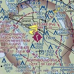
| Sectional chart |
|---|
|
| Airport distance calculator |
|---|
|
|
| Sunrise and sunset |
|---|
|
Times for 05-Jun-2026
| | Local
(UTC-5) | | Zulu
(UTC) |
|---|
| Morning civil twilight | | 04:41 | | 09:41 |
| Sunrise | | 05:21 | | 10:21 |
| Sunset | | 21:04 | | 02:04 |
| Evening civil twilight | | 21:44 | | 02:44 |
|
| Current date and time |
|---|
| Zulu (UTC) | 05-Jun-2026 09:15:05 |
|---|
| Local (UTC-5) | 05-Jun-2026 04:15:05 |
|---|
|
| METAR |
|---|
| KGPZ | 050856Z AUTO 15006KT 10SM BKN080 13/13 A2982 RMK AO2 SLP098 T01330133 51005 $
|
|
| TAF |
|---|
KHIB
29nm E | 050528Z 0506/0606 29006KT P6SM -RA FEW022 BKN100 FM050900 00000KT 3SM BR BKN050 FM051100 00000KT 5SM BR BKN035 FM051500 00000KT P6SM SCT190 FM051800 29006KT P6SM SCT080
|
|
| NOTAMs |
|---|
NOTAMs are issued by the DoD/FAA and will open in a separate window not controlled by AirNav.
|
|

