FAA INFORMATION EFFECTIVE 14 MAY 2026
Location
| FAA Identifier: | GQQ |
| Lat/Long: | 40-45-12.2000N 082-43-25.7000W
40-45.203333N 082-43.428333W
40.7533889,-82.7238056
(estimated) |
| Elevation: | 1224 ft. / 373.1 m (surveyed) |
| Variation: | 07W (2010) |
| From city: | 3 miles NE of GALION, OH |
| Time zone: | UTC -4 (UTC -5 during Standard Time) |
| Zip code: | 44833 |
Airport Operations
| Airport use: | Open to the public |
| Activation date: | 05/1949 |
| Control tower: | no |
| ARTCC: | CLEVELAND CENTER |
| FSS: | CLEVELAND FLIGHT SERVICE STATION |
| NOTAMs facility: | CLE (NOTAM-D service available) |
| Attendance: | MON-FRI 1000-1700 |
| Wind indicator: | lighted |
| Segmented circle: | no |
| Lights: | ACTVT REIL RWY 05 & 23; PAPI RWY 05 & 23; MIRL RWY 05/23 - CTAF. |
| Beacon: | white-green (lighted land airport)
Operates sunset to sunrise. |
Airport Communications
| CTAF/UNICOM: | 122.8 |
| CLEVELAND APPROACH: | 128.35 |
| CLEVELAND DEPARTURE: | 128.35 |
| CLEARANCE DELIVERY: | 126.8 |
| WX ASOS at MFD (10 nm NE): | 125.3 (419-520-7277) |
| WX AWOS-3 at 17G (12 nm W): | 126.625 (419-562-0279) |
| WX AWOS-3PT at 4I9 (15 nm SW): | 121.4 (419-947-1039) |
| WX ASOS at MNN (18 nm SW): | 119.975 (740-223-7502) |
- APCH/DEP SVC PRVDD BY CLEVELAND APCH (CLE) 0600-0100. APCH/DEP SVC PRVDD BY CLEVELAND ARTCC (ZOB) ON FREQS 134.9/269.475 (MANSFIELD RCAG) 0100-0600.
Nearby radio navigation aids
| VOR radial/distance | | VOR name | | Freq | | Var |
|---|
| BUDr067/(17.5) | | BUCKEYE VOR | | 109.80 | | 05W |
| APEr356/36.7 | | APPLETON VORTAC | | 116.70 | | 06W |
| NDB name | | Hdg/Dist | | Freq | | Var | | ID |
|---|
| MANNS | | 272/12.7 | | 372 | | 06W | | MF | -- ..-. |
| TIFFIN | | 138/30.3 | | 269 | | 05W | | TII | - .. .. |
Airport Services
| Fuel available: | 100LL JET-A
100LL:100LL AVBL H24 SELF SVC VIA CREDIT CARD.
A:FOR JET A AFT HRS CALL 419-565-3647. |
| Parking: | hangars and tiedowns |
| Airframe service: | MAJOR |
| Powerplant service: | MAJOR |
| Bottled oxygen: | NONE |
| Bulk oxygen: | NONE |
Runway Information
Runway 5/23
| Dimensions: | 3504 x 75 ft. / 1068 x 23 m |
| Surface: | asphalt, in excellent condition |
| Weight bearing capacity: | |
| Runway edge lights: | medium intensity |
| RUNWAY 5 | | RUNWAY 23 |
| Latitude: | 40-45.008383N | | 40-45.398363N |
| Longitude: | 082-43.707050W | | 082-43.147940W |
| Elevation: | 1222.1 ft. | | 1218.4 ft. |
| Traffic pattern: | left | | left |
| Runway heading: | 054 magnetic, 047 true | | 234 magnetic, 227 true |
| Displaced threshold: | 186 ft. | | no |
| Markings: | nonprecision, in good condition | | nonprecision, in good condition |
| Visual slope indicator: | 4-light PAPI on left (3.00 degrees glide path) | | 4-light PAPI on left (3.00 degrees glide path) |
| Runway end identifier lights: | yes | | yes |
| Touchdown point: | yes, no lights | | yes, no lights |
| Obstructions: | 35 ft. tree, 568 ft. from runway, 103 ft. left of centerline, 10:1 slope to clear
APCH RATIO 18:1 TO DTHR. | | 10 ft. crops, 201 ft. from runway
+10 CROPS, 172 FT DIST, 200 FT L/R. |
Airport Ownership and Management from official FAA records
| Ownership: | Publicly-owned |
| Owner: | CITY OF GALION
301 HARDING WAY E
GALION, OH 44833-2087
Phone 419-468-2818 |
| Manager: | DR HOLBROOK RILES JR
8240 STATE ROUTE 309
GALION, OH 44833-9712
Phone 419-295-1821
FBO 419-565-3647. |
Additional Remarks
| - | STUDENT TRAINING ACTIVITY. |
| - | FOR CD CTC CLEVELAND APCH AT 216-352-2323, WHEN APCH CLSD CTC CLEVELAND ARTCC AT 440-774-0223/0490. |
Instrument Procedures
NOTE: All procedures below are presented as PDF files. If you need a reader for these files, you should download the free Adobe Reader.NOT FOR NAVIGATION. Please procure official charts for flight.
FAA instrument procedures published for use from 14 May 2026 at 0901Z to 11 June 2026 at 0900Z.
IAPs - Instrument Approach Procedures |
|---|
| RNAV (GPS) RWY 05 | |
download (203KB) |
| RNAV (GPS) RWY 23 | |
download (183KB) |
| NOTE: Special Take-Off Minimums/Departure Procedures apply | |
download (164KB) |
Other nearby airports with instrument procedures:
12G - Shelby Community Airport (7 nm N)
KMFD - Mansfield Lahm Regional Airport (10 nm NE)
17G - Port Bucyrus/Crawford County Airport (12 nm W)
4I9 - Morrow County Airport (15 nm SW)
8G1 - Willard Airport (17 nm N)
KMNN - Marion Municipal Airport (18 nm SW)
|
|

Road maps at:
MapQuest
Bing
Google
| Aerial photo |
|---|
WARNING: Photo may not be current or correct
 Photo taken 07-Sep-2008
Do you have a better or more recent aerial photo of Galion Municipal Airport that you would like to share? If so, please send us your photo.
|
| Sectional chart |
|---|
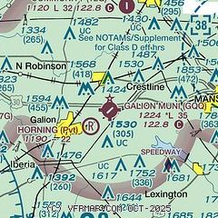
|
CAUTION: Diagram may not be current

| Airport distance calculator |
|---|
|
|
| Sunrise and sunset |
|---|
|
Times for 03-Jun-2026
| | Local
(UTC-4) | | Zulu
(UTC) |
|---|
| Morning civil twilight | | 05:29 | | 09:29 |
| Sunrise | | 06:02 | | 10:02 |
| Sunset | | 20:56 | | 00:56 |
| Evening civil twilight | | 21:29 | | 01:29 |
|
| Current date and time |
|---|
| Zulu (UTC) | 03-Jun-2026 11:06:47 |
|---|
| Local (UTC-4) | 03-Jun-2026 07:06:47 |
|---|
|
| METAR |
|---|
KMFD
10nm E | 031052Z 32006KT 10SM CLR 12/04 A3037 RMK AO2 SLP282 T01220044 $
|
KMNN
18nm SW | 031053Z AUTO 00000KT 10SM CLR 10/07 A3037 RMK AO2 SLP284 T01000072 $
|
|
| TAF |
|---|
KMFD
10nm E | 030536Z 0306/0406 VRB02KT P6SM FEW250 FM031500 01006KT P6SM SKC FM040100 VRB03KT P6SM FEW250
|
|
| NOTAMs |
|---|
NOTAMs are issued by the DoD/FAA and will open in a separate window not controlled by AirNav.
|
|


