FAA INFORMATION EFFECTIVE 30 OCTOBER 2025
Location
| FAA Identifier: | GRD |
| Lat/Long: | 34-15-01.4175N 082-09-28.1136W
34-15.023625N 082-09.468560W
34.2503938,-82.1578093
(estimated) |
| Elevation: | 631.2 ft. / 192.4 m (surveyed) |
| Variation: | 07W (2020) |
| From city: | 3 miles N of GREENWOOD, SC |
| Time zone: | UTC -5 (UTC -4 during Daylight Saving Time) |
| Zip code: | 29649 |
Airport Operations
| Airport use: | Open to the public |
| Activation date: | 11/1943 |
| Control tower: | no |
| ARTCC: | ATLANTA CENTER |
| FSS: | ANDERSON FLIGHT SERVICE STATION |
| NOTAMs facility: | GRD (NOTAM-D service available) |
| Attendance: | SAT 0800-1700, ALL MON-FRI 0730-1800, ALL SUN 1100-1700 |
| Wind indicator: | lighted |
| Segmented circle: | yes |
| Lights: | MIRL RY 09/27 PRESET ON MED INTST DUSK-2300; TO INCR INTST & ACTVT REIL RYS 09 & 27 - CTAF. AFTER 2300, ACTVT MIRL RY 09/27, REIL RYS 09 & 27 AND ODALS RY 27 - CTAF. |
| Beacon: | white-green (lighted land airport)
Operates sunset to sunrise. |
Airport Communications
| CTAF/UNICOM: | 122.975 |
| WX ASOS: | 121.125 (864-388-9115) |
| GREER APPROACH: | 120.6 |
| GREER DEPARTURE: | 120.6 |
| WX AWOS-3 at LUX (19 nm NE): | 123.975 (864-682-3639) |
- APCH/DEP SVC PRVDD BY ATLANTA ARTCC ON FREQS 135.35/263.125 (OWING RCAG) WHEN APCH CTL CLSD.
Nearby radio navigation aids
| VOR radial/distance | | VOR name | | Freq | | Var |
|---|
| IRQr004/32.6 | | COLLIERS VORTAC | | 113.90 | | 04W |
| ELWr108/32.7 | | ELECTRIC CITY VORTAC | | 108.60 | | 00E |
| NDB name | | Hdg/Dist | | Freq | | Var | | ID |
|---|
| ENOREE | | 269/26.1 | | 278 | | 07W | | EOE | . --- . |
| UNION COUNTY | | 230/36.4 | | 326 | | 06W | | UOT | ..- --- - |
Airport Services
| Fuel available: | 100LL JET-A |
| Parking: | tiedowns |
| Airframe service: | MAJOR |
| Powerplant service: | MINOR |
| Bottled oxygen: | NONE |
| Bulk oxygen: | NONE |
Runway Information
Runway 9/27
| Dimensions: | 5001 x 100 ft. / 1524 x 30 m |
| Surface: | concrete, in excellent condition |
| Weight bearing capacity: | | PCN 35 /F/C/X/T | | Single wheel: | 89.0 | | Double wheel: | 122.0 |
|
| Runway edge lights: | medium intensity |
| RUNWAY 9 | | RUNWAY 27 |
| Latitude: | 34-14.889478N | | 34-14.958432N |
| Longitude: | 082-10.039265W | | 082-09.049828W |
| Elevation: | 628.8 ft. | | 620.3 ft. |
| Traffic pattern: | left | | left |
| Runway heading: | 092 magnetic, 085 true | | 272 magnetic, 265 true |
| Markings: | nonprecision, in good condition | | nonprecision, in good condition |
| Visual slope indicator: | 2-light PAPI on left (3.00 degrees glide path) | | 2-light PAPI on left (3.00 degrees glide path) |
| Approach lights: | | | ODALS: omnidirectional approach lighting system |
| Runway end identifier lights: | yes | | yes |
| Touchdown point: | yes, no lights | | yes, no lights |
| Obstructions: | 45 ft. tree, 1223 ft. from runway, 32 ft. right of centerline, 22:1 slope to clear | | 49 ft. tree, 1614 ft. from runway, 71 ft. left of centerline, 28:1 slope to clear |
Runway 5/23
| Dimensions: | 3600 x 60 ft. / 1097 x 18 m |
| Surface: | asphalt/aggregate friction seal coat, in fair condition |
| RUNWAY 5 | | RUNWAY 23 |
| Latitude: | 34-14.948000N | | 34-15.376167N |
| Longitude: | 082-09.610667W | | 082-09.115333W |
| Elevation: | 627.6 ft. | | 617.7 ft. |
| Traffic pattern: | left | | left |
| Runway heading: | 051 magnetic, 044 true | | 231 magnetic, 224 true |
| Markings: | basic, in good condition | | basic, in good condition |
| Touchdown point: | yes, no lights | | yes, no lights |
| Obstructions: | 50 ft. tree, 1865 ft. from runway, 248 ft. left of centerline, 33:1 slope to clear | | 66 ft. tree, 1472 ft. from runway, 119 ft. right of centerline, 19:1 slope to clear |
Airport Ownership and Management from official FAA records
| Ownership: | Publicly-owned |
| Owner: | GREENWOOD COUNTY
600 MONUMENT STREET
GREENWOOD, SC 29646
Phone 864-942-8502 |
| Manager: | RETT TEMPLETON
528 MONUMENT STREET, ROOM B-03
GREENWOOD, SC 29649
Phone (864) 942-8556
FBO PHONE 864-942-9634 |
Additional Remarks
| - | TWY A PARALLEL TO RY 09/27; DROPOFFS EACH SIDE OF TWY BEYOND SHOULDER. |
| - | FOR CD IF UNA TO CTC ON FSS FREQ, CTC GREER APCH AT 864-877-8275, WHEN APCH CLSD CTC ATLANTA ARTCC AT 770-210-7692. |
Instrument Procedures
NOTE: All procedures below are presented as PDF files. If you need a reader for these files, you should download the free Adobe Reader.NOT FOR NAVIGATION. Please procure official charts for flight.
FAA instrument procedures published for use from 30 October 2025 at 0901Z to 27 November 2025 at 0900Z.
IAPs - Instrument Approach Procedures |
|---|
| RNAV (GPS) RWY 09 | |
download (257KB) |
| RNAV (GPS) RWY 27 | |
download (293KB) |
| NOTE: Special Alternate Minimums apply | |
download (167KB) |
| NOTE: Special Take-Off Minimums/Departure Procedures apply | |
download (218KB) |
Other nearby airports with instrument procedures:
KLUX - Laurens County Airport (19 nm NE)
KEOE - Newberry County Airport (26 nm E)
6J4 - Saluda County Airport (27 nm SE)
KAND - Anderson Regional Airport (31 nm NW)
KGYH - Donaldson Field Airport (32 nm N)
|
|

Road maps at:
MapQuest
Bing
Google
| Aerial photo |
|---|
WARNING: Photo may not be current or correct
 Photo by Kevin Bradley and Kevin Nielsen
Photo taken 08-Jan-2010
Photo by Kevin Bradley and Kevin Nielsen
Photo taken 08-Jan-2010
Do you have a better or more recent aerial photo of Greenwood County Airport that you would like to share? If so, please send us your photo.
|
| Sectional chart |
|---|
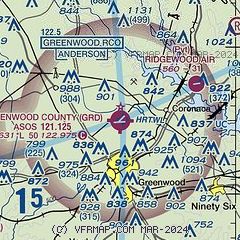
|
| Airport distance calculator |
|---|
|
|
| Sunrise and sunset |
|---|
|
Times for 05-Nov-2025
| | Local
(UTC-5) | | Zulu
(UTC) |
|---|
| Morning civil twilight | | 06:27 | | 11:27 |
| Sunrise | | 06:53 | | 11:53 |
| Sunset | | 17:31 | | 22:31 |
| Evening civil twilight | | 17:57 | | 22:57 |
|
| Current date and time |
|---|
| Zulu (UTC) | 05-Nov-2025 16:43:41 |
|---|
| Local (UTC-5) | 05-Nov-2025 11:43:41 |
|---|
|
| METAR |
|---|
| KGRD | 051556Z AUTO 23011KT 10SM CLR 18/08 A3028 RMK AO2 SLP252 T01830083
|
KLUX
19nm NE | 051615Z AUTO 24010G17KT 10SM CLR 18/07 A3025 RMK AO2
|
|
| TAF |
|---|
KAND
31nm NW | 051228Z 0512/0612 00000KT 1/4SM FG VV001 FM051400 22006KT P6SM SKC FM051800 23012G19KT P6SM SKC FM060200 25009KT P6SM SKC FM060600 27006KT P6SM SKC FM060900 32004KT P6SM SKC
|
KGMU
37nm N | 051123Z 0512/0612 23006KT P6SM SKC FM051300 23008KT P6SM SKC FM051600 23012G19KT P6SM SKC FM060100 25009KT P6SM FEW250 FM060500 29006KT P6SM SKC FM060900 01005KT P6SM SKC
|
KGSP
39nm N | 051123Z 0512/0612 23005KT P6SM SKC FM051300 23009KT P6SM SKC FM051600 23014G22KT P6SM SKC FM060100 25007KT P6SM FEW250 FM060600 30004KT P6SM SKC
|
|
| NOTAMs |
|---|
NOTAMs are issued by the DoD/FAA and will open in a separate window not controlled by AirNav.
|
|

