FAA INFORMATION EFFECTIVE 14 MAY 2026
Location
| FAA Identifier: | GRR |
| Lat/Long: | 42-52-51.0000N 085-31-22.1000W
42-52.850000N 085-31.368333W
42.8808333,-85.5228056
(estimated) |
| Elevation: | 793.6 ft. / 241.9 m (surveyed) |
| Variation: | 06W (2020) |
| From city: | 6 miles SE of GRAND RAPIDS, MI |
| Time zone: | UTC -4 (UTC -5 during Standard Time) |
| Zip code: | 49512 |
Airport Operations
| Airport use: | Open to the public |
| Activation date: | 05/1963 |
| Control tower: | yes |
| ARTCC: | CHICAGO CENTER |
| FSS: | LANSING FLIGHT SERVICE STATION |
| NOTAMs facility: | GRR (NOTAM-D service available) |
| Attendance: | CONTINUOUS |
| Wind indicator: | lighted |
| Segmented circle: | no |
| Lights: | WHEN ATCT CLSD ACTVT MALSR RWY 08R, 26L, & 35; REIL RWY 08L, 26R, & 17; HIRL RWY 08R/26L & 17/35; MIRL RWY 08L/26R - CTAF. |
| Beacon: | white-green (lighted land airport)
Operates sunset to sunrise. |
| Fire and rescue: | ARFF index C |
| International operations: | customs landing rights airport
MON-FRI TWO HRS PPR FOR CUSTOMS CALL 616-942-5245,
PAGER 616-249-5380. CALL PRIOR TO 1600 ON PRECEDING
FRIDAY FOR AFTER HOURS SVC. |
Airport Communications
| CTAF: | 135.65 |
| UNICOM: | 122.95 |
| ATIS: | 118.725 |
| WX ASOS: | PHONE 616-986-5029 |
| GRAND RAPIDS GROUND: | 121.8 [0530-0000] |
| GRAND RAPIDS TOWER: | 135.65 339.8 [0530-0000] |
| GREAT LAKES APPROACH: | 124.6 ;NORTH 128.4 ;SOUTH |
| GREAT LAKES DEPARTURE: | 124.6 ;NORTH 128.4 ;SOUTH |
| CLEARANCE DELIVERY: | 119.3 |
| CLASS C: | 124.6 ;NORTH 128.4 ;SOUTH |
| EMERG: | 121.5 243.0 |
| IC: | 128.4 ;SOUTH |
| WX AWOS-3PT at 8D4 (16 nm NW): | 126.650 (616-887-6314) |
- APCH/DEP SVC PRVDD BY CHICAGO ARTCC (ZAU) ON FREQS 128.4 (GRAND RAPIDS RCAG) WHEN GREAT LAKES APCH CTL CLSD.
Nearby radio navigation aids
| VOR radial/distance | | VOR name | | Freq | | Var |
|---|
| VIOr353/5.8 | | VICTORY VOR/DME | | 115.95 | | 04W |
| PMMr046/35.8 | | PULLMAN VOR/DME | | 112.10 | | 00E |
| NDB name | | Hdg/Dist | | Freq | | Var | | ID |
|---|
| KNOBS | | 268/6.4 | | 263 | | 06W | | GR | --. .-. |
Airport Services
| Fuel available: | 100LL JET-A |
| Parking: | hangars and tiedowns |
| Airframe service: | MAJOR |
| Powerplant service: | MAJOR |
| Bottled oxygen: | HIGH |
| Bulk oxygen: | HIGH |
Runway Information
Runway 8R/26L
| Dimensions: | 10001 x 150 ft. / 3048 x 46 m |
| Surface: | concrete/grooved, in good condition |
| Weight bearing capacity: | | Double wheel: | 190.0 | | Double tandem: | 350.0 |
|
| Runway edge lights: | high intensity |
| RUNWAY 8R | | RUNWAY 26L |
| Latitude: | 42-52.597993N | | 42-52.846827N |
| Longitude: | 085-32.531402W | | 085-30.318638W |
| Elevation: | 791.5 ft. | | 789.3 ft. |
| Traffic pattern: | left | | left |
| Runway heading: | 087 magnetic, 081 true | | 267 magnetic, 261 true |
| Declared distances: | TORA:10001 TODA:10001 ASDA:10001 LDA:10001 | | TORA:10001 TODA:10001 ASDA:10001 LDA:10001 |
| Markings: | precision, in good condition | | precision, in good condition |
| Visual slope indicator: | | | 4-light PAPI on left (3.00 degrees glide path) |
| RVR equipment: | touchdown, rollout | | touchdown, rollout |
| Approach lights: | MALSR: 1,400 foot medium intensity approach lighting system with runway alignment indicator lights | | MALSR: 1,400 foot medium intensity approach lighting system with runway alignment indicator lights |
| Runway end identifier lights: | no | | no |
| Touchdown point: | yes, no lights | | yes, no lights |
| Instrument approach: | ILS | | ILS |
| Obstructions: | none | | 24 ft. bldg, 1170 ft. from runway, 260 ft. left of centerline, 40:1 slope to clear |
Runway 17/35
| Dimensions: | 8501 x 150 ft. / 2591 x 46 m |
| Surface: | concrete/grooved, in good condition |
| Weight bearing capacity: | | Double wheel: | 190.0 | | Double tandem: | 350.0 |
|
| Runway edge lights: | high intensity |
| RUNWAY 17 | | RUNWAY 35 |
| Latitude: | 42-53.371842N | | 42-51.988455N |
| Longitude: | 085-31.155352W | | 085-30.867842W |
| Elevation: | 782.3 ft. | | 789.3 ft. |
| Traffic pattern: | left | | left |
| Runway heading: | 177 magnetic, 171 true | | 357 magnetic, 351 true |
| Declared distances: | TORA:8501 TODA:8501 ASDA:8501 LDA:8501 | | TORA:8501 TODA:8501 ASDA:8501 LDA:8501 |
| Markings: | nonprecision, in good condition | | precision, in good condition |
| Visual slope indicator: | 4-light PAPI on right (3.00 degrees glide path) | | 4-light PAPI on right (3.00 degrees glide path) |
| RVR equipment: | touchdown, rollout | | touchdown, rollout |
| Approach lights: | | | MALSR: 1,400 foot medium intensity approach lighting system with runway alignment indicator lights |
| Runway end identifier lights: | yes | | no |
| Touchdown point: | yes, no lights | | yes, no lights |
| Instrument approach: | | | ILS |
Runway 8L/26R
| Dimensions: | 5001 x 100 ft. / 1524 x 30 m |
| Surface: | asphalt/grooved, in good condition |
| Weight bearing capacity: | | Single wheel: | 110.0 | | Double wheel: | 160.0 |
|
| Runway edge lights: | medium intensity |
| RUNWAY 8L | | RUNWAY 26R |
| Latitude: | 42-53.329823N | | 42-53.454173N |
| Longitude: | 085-32.411565W | | 085-31.304908W |
| Elevation: | 786.2 ft. | | 783.8 ft. |
| Traffic pattern: | left | | left |
| Runway heading: | 087 magnetic, 081 true | | 267 magnetic, 261 true |
| Declared distances: | TORA:5001 TODA:5001 ASDA:5001 LDA:5001 | | TORA:5001 TODA:5001 ASDA:5001 LDA:5001 |
| Markings: | nonprecision, in good condition | | nonprecision, in good condition |
| Visual slope indicator: | 4-box VASI on left (3.00 degrees glide path) | | 4-box VASI on left (3.00 degrees glide path) |
| Runway end identifier lights: | yes | | yes |
| Touchdown point: | yes, no lights | | yes, no lights |
Airport Ownership and Management from official FAA records
| Ownership: | Publicly-owned |
| Owner: | GERALD R FORD INTL ARPT AUTH
5500 44TH ST SE
GRAND RAPIDS, MI 49512
Phone 616-233-6000 |
| Manager: | TORRANCE RICHARDSON
5500 44TH ST SE
GRAND RAPIDS, MI 49512
Phone 616-233-6000 |
Additional Remarks
| A39-08L/26R | PCR VALUE: 270/F/C/X/T |
| A39-17/35 | PCR VALUE: 660/R/C/W/T |
| A39-08R/26L | PCR VALUE: 470/R/D/W/T |
| - | TWY F NORTH OF TWY V, TWY J BTN TWY F & TWY J3 & TWY G CLSD TO AIRCRAFT OVER 100,000 LBS; TWY F SOUTH OF TWY V & TWY J EAST OF TWY F & WEST OF TWY J3 CLSD TO ACFT OVER 47,000 LBS. |
| - | TWY R NORTH OF TWY D, TWY Y NORTH OF TWY D, TWY Z NORTH OF TWY D AND TWY N ARE NON-MOVEMENT AREAS. |
| - | PUSHBACK ADVISORIES ON THE TERMINAL RAMP ARE NOT PRVDD BY ATC. |
| - | ARPT PSNL WILL MNT CTAF WHEN ATCT IS CLSD. |
| - | TWY Y 400 FT NORTH OF TWY D CLSD TO ACFT OVER 100,000 LBS.; TWY R NORTH OF TWY D CLSD TO ACFT OVER 175,000 LBS. |
| - | AIR CARRIER APRON CLOSED TO GA AIRCRAFT. |
| - | CTC FBO FOR THEIR HRS OF OPN. |
| - | FOR CD WHEN TWR CLSD CTC GREAT LAKES APCH AT 269-459-3344, WHEN APCH CLSD CTC CHICAGO ARTCC AT 630-906-8921. |
| - | TWY D HOLD PAD FOR RWY 26L CLSD TO ACFT WITH WINGSPAN GTR THAN 49 FT. |
| - | BIRDS ON & INVOF ARPT. |
| - | NOISE ABATEMENT PROCEDURES: RY 08R DEP ON RY HEADING UNTIL REACHING THE HWY EAST OF ARPT; RY 26L ON APCH TO ARPT TURN FINAL AT HWY EAST OF ARPT. |
| - | PPR FOR ACFT WITH 171 FT WINGSPAN OR LARGER. |
Instrument Procedures
NOTE: All procedures below are presented as PDF files. If you need a reader for these files, you should download the free Adobe Reader.NOT FOR NAVIGATION. Please procure official charts for flight.
FAA instrument procedures published for use from 14 May 2026 at 0901Z to 11 June 2026 at 0900Z.
IAPs - Instrument Approach Procedures |
|---|
| ILS OR LOC RWY 08R | |
download (244KB) |
| ILS OR LOC RWY 26L | |
download (286KB) |
| ILS OR LOC RWY 35 | |
download (301KB) |
| ILS RWY 35 (SA CAT I - II) | |
download (283KB) |
| RNAV (GPS) RWY 08L | |
download (225KB) |
| RNAV (GPS) RWY 08R | |
download (236KB) |
| RNAV (GPS) RWY 17 | |
download (227KB) |
| RNAV (GPS) RWY 26L | |
download (236KB) |
| RNAV (GPS) RWY 26R | |
download (227KB) |
| RNAV (GPS) RWY 35 | |
download (248KB) |
| VOR RWY 17 | |
download (232KB) |
| NOTE: Special Alternate Minimums apply | |
download (140KB) |
| NOTE: Special Take-Off Minimums/Departure Procedures apply | |
download (181KB) |
Other nearby airports with instrument procedures:
9D9 - Hastings Airport (15 nm SE)
8D4 - Paul C Miller/Sparta Airport (16 nm NW)
Z98 - Ottawa Executive Airport (18 nm W)
6D6 - Greenville Municipal Airport (20 nm NE)
Y70 - Ionia County Airport (21 nm E)
|
|

Road maps at:
MapQuest
Bing
Google
| Aerial photo |
|---|
WARNING: Photo may not be current or correct
 Photo taken 08-Sep-2017
looking north from 8,500 MSL.
Photo taken 08-Sep-2017
looking north from 8,500 MSL.
Do you have a better or more recent aerial photo of Gerald R Ford International Airport that you would like to share? If so, please send us your photo.
|
| Sectional chart |
|---|
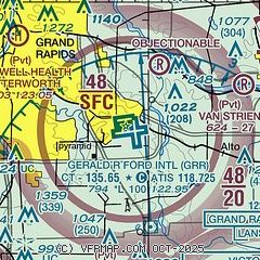
|
CAUTION: Diagram may not be current
 Download PDF
of official airport diagram from the FAA
| Airport distance calculator |
|---|
|
|
| Sunrise and sunset |
|---|
|
Times for 30-May-2026
| | Local
(UTC-4) | | Zulu
(UTC) |
|---|
| Morning civil twilight | | 05:34 | | 09:34 |
| Sunrise | | 06:08 | | 10:08 |
| Sunset | | 21:11 | | 01:11 |
| Evening civil twilight | | 21:45 | | 01:45 |
|
| Current date and time |
|---|
| Zulu (UTC) | 31-May-2026 02:01:18 |
|---|
| Local (UTC-4) | 30-May-2026 22:01:18 |
|---|
|
| METAR |
|---|
| KGRR | 310153Z 07011KT 10SM BKN250 17/05 A3017 RMK AO2 SLP215 T01670050 VISNO RWY 8R $
|
|
| TAF |
|---|
| KGRR | 301735Z 3018/3118 08012G20KT P6SM SCT250 FM302300 08008KT P6SM FEW250 FM311200 12007KT P6SM SCT250
|
|
| NOTAMs |
|---|
NOTAMs are issued by the DoD/FAA and will open in a separate window not controlled by AirNav.
|
|


