FAA INFORMATION EFFECTIVE 14 MAY 2026
Location
| FAA Identifier: | HDC |
| Lat/Long: | 30-31-18.0750N 090-25-06.1670W
30-31.301250N 090-25.102783W
30.5216875,-90.4183797
(estimated) |
| Elevation: | 46.1 ft. / 14 m (estimated) |
| Variation: | 00E (2010) |
| From city: | 3 miles NE of HAMMOND, LA |
| Time zone: | UTC -5 (UTC -6 during Standard Time) |
| Zip code: | 70401 |
Airport Operations
| Airport use: | Open to the public |
| Activation date: | 11/1941 |
| Control tower: | yes |
| ARTCC: | HOUSTON CENTER |
| FSS: | DE RIDDER FLIGHT SERVICE STATION |
| NOTAMs facility: | DRI (NOTAM-D service available) |
| Attendance: | MON-FRI 0600-2000, ALL SAT-SUN 0800-1800 |
| Pattern altitude: | 1002.1 ft. MSL |
| Wind indicator: | lighted |
| Segmented circle: | no |
| Lights: | ACTVT MALSR RWY 18; REIL RWY 13, 31, & 36; MIRL RWY 13/31 & 18/36; PRESET LOW INTST DUSK-DAWN; TO INCR INTST - CTAF. |
| Beacon: | white-green (lighted land airport)
Operates sunset to sunrise. |
Airport Communications
| CTAF: | 120.575 |
| ATIS: | 118.325 |
| WX AWOS-3PT: | PHONE 985-277-5670 |
| HAMMOND GROUND: | 119.85 [0800-1800] |
| HAMMOND TOWER: | 120.575 [0800-1800] |
| NEW ORLEANS APPROACH: | 119.3 125.5 |
| NEW ORLEANS DEPARTURE: | 119.3 125.5 |
| CLEARANCE DELIVERY: | 119.3 ;WHEN TWR CLSD |
Nearby radio navigation aids
| VOR radial/distance | | VOR name | | Freq | | Var |
|---|
| RQRr017/27.5 | | RESERVE VOR/DME | | 110.80 | | 02E |
| PCUr261/35.6 | | PICAYUNE VOR/DME | | 113.95 | | 05E |
| NDB name | | Hdg/Dist | | Freq | | Var | | ID |
|---|
| ANGER | | 178/5.1 | | 212 | | 00E | | HP | .... .--. |
| BOGALUSA | | 233/35.9 | | 353 | | 00W | | GVB | --. ...- -... |
Airport Services
| Fuel available: | 100LL JET-A |
| Parking: | hangars and tiedowns |
| Airframe service: | MAJOR |
| Powerplant service: | MAJOR |
| Bottled oxygen: | NONE |
| Bulk oxygen: | NONE |
Runway Information
Runway 13/31
| Dimensions: | 6502 x 100 ft. / 1982 x 30 m |
| Surface: | asphalt/concrete, in good condition |
| Weight bearing capacity: | | Single wheel: | 22.0 | | Double wheel: | 33.0 |
|
| Runway edge lights: | medium intensity |
| RUNWAY 13 | | RUNWAY 31 |
| Latitude: | 30-31.675627N | | 30-30.923717N |
| Longitude: | 090-25.508825W | | 090-24.625358W |
| Elevation: | 46.0 ft. | | 40.1 ft. |
| Traffic pattern: | left | | left |
| Runway heading: | 135 | | 315 |
| Displaced threshold: | no | | 690 ft. |
| Markings: | nonprecision, in good condition | | nonprecision, in good condition |
| Visual slope indicator: | 4-light PAPI on left (3.30 degrees glide path) | | 4-light PAPI on left (3.30 degrees glide path) |
| Runway end identifier lights: | yes | | yes
RWY 31 RIGHT SIDE REIL OTS. |
| Touchdown point: | yes, no lights | | yes, no lights |
| Obstructions: | none | | 91 ft. trees, 1700 ft. from runway, 17:1 slope to clear
APCH SLOPE 26:1 TO DSPLCD THLD. |
Runway 18/36
| Dimensions: | 5001 x 150 ft. / 1524 x 46 m |
| Surface: | concrete, in good condition |
| Weight bearing capacity: | | Single wheel: | 27.0 | | Double wheel: | 41.0 |
|
| Runway edge lights: | medium intensity |
| RUNWAY 18 | | RUNWAY 36 |
| Latitude: | 30-31.715780N | | 30-30.890802N |
| Longitude: | 090-25.153168W | | 090-25.145303W |
| Elevation: | 43.5 ft. | | 40.0 ft. |
| Traffic pattern: | left | | left |
| Runway heading: | 180 | | 360 |
| Markings: | precision, in good condition | | precision, in good condition |
| Visual slope indicator: | 4-light PAPI on left (3.00 degrees glide path) | | 4-light PAPI on left (3.00 degrees glide path) |
| Approach lights: | MALSR: 1,400 foot medium intensity approach lighting system with runway alignment indicator lights | | |
| Runway end identifier lights: | no | | yes |
| Touchdown point: | yes, no lights | | yes, no lights |
| Instrument approach: | ILS | | |
Airport Ownership and Management from official FAA records
| Ownership: | Publicly-owned |
| Owner: | CITY OF HAMMOND
PO BOX 2788
HAMMOND, LA 70404-2788
Phone (985) 277-5601 |
| Manager: | TONY MICHELLI
600 JUDGE LEON FORD DRIVE
HAMMOND, LA 70401
Phone 985-277-5667 |
Additional Remarks
| - | CTC APRT MGR FOR DSGND RAMP SPACE FOR PUB USE. |
| - | BIRDS, DEER & COYOTES ON & INVOF ARPT. |
| - | MIL & GOVT ACFT SVCD AT NW APN AT FBO. |
| - | FOR CD WHEN ATCT IS CLSD CTC MSY APCH AT 504-471-4350 OR 119.3. |
| - | CAUTION: TWY D UNMKD AND UNLGTD. |
| - | PILOTS CONDUCTING EFVS OPS; BE AWARE LED ALS IN USE RWY 18. |
Instrument Procedures
NOTE: All procedures below are presented as PDF files. If you need a reader for these files, you should download the free Adobe Reader.NOT FOR NAVIGATION. Please procure official charts for flight.
FAA instrument procedures published for use from 14 May 2026 at 0901Z to 11 June 2026 at 0900Z.
IAPs - Instrument Approach Procedures |
|---|
| ILS OR LOC RWY 18 | |
download (285KB) |
| RNAV (GPS) RWY 13 | |
download (208KB) |
| RNAV (GPS) RWY 18 | |
download (252KB) |
| RNAV (GPS) RWY 31 | |
download (205KB) |
| RNAV (GPS) RWY 36 | |
download (263KB) |
| NOTE: Special Alternate Minimums apply | |
download (163KB) |
| NOTE: Special Take-Off Minimums/Departure Procedures apply | |
download (116KB) |
Other nearby airports with instrument procedures:
KAPS - Port of South Louisiana Executive Regional Airport (27 nm S)
KASD - Slidell Airport (33 nm E)
KMSY - Louis Armstrong New Orleans International Airport (33 nm S)
KBXA - George R Carr Memorial Air Field (34 nm NE)
KREG - Louisiana Regional Airport (34 nm SW)
|
|

Road maps at:
MapQuest
Bing
Google
| Aerial photo |
|---|
WARNING: Photo may not be current or correct
 Photo by Jay Taffet / Courtesy of Hammond Air Center
Photo taken 25-Sep-2013
looking northwest.
Photo by Jay Taffet / Courtesy of Hammond Air Center
Photo taken 25-Sep-2013
looking northwest.
Do you have a better or more recent aerial photo of Hammond Northshore Regional Airport that you would like to share? If so, please send us your photo.
|
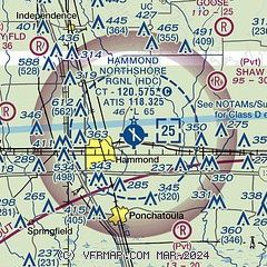
| Sectional chart |
|---|
|
CAUTION: Diagram may not be current

| Airport distance calculator |
|---|
|
|
| Sunrise and sunset |
|---|
|
Times for 06-Jun-2026
| | Local
(UTC-5) | | Zulu
(UTC) |
|---|
| Morning civil twilight | | 05:33 | | 10:33 |
| Sunrise | | 06:00 | | 11:00 |
| Sunset | | 20:01 | | 01:01 |
| Evening civil twilight | | 20:28 | | 01:28 |
|
| Current date and time |
|---|
| Zulu (UTC) | 06-Jun-2026 22:40:24 |
|---|
| Local (UTC-5) | 06-Jun-2026 17:40:24 |
|---|
|
| METAR |
|---|
| KHDC | 062215Z AUTO 00000KT 10SM SCT037 BKN045 OVC065 27/25 A2991 RMK AO2 T02690248
|
|
| TAF |
|---|
| KHDC | 061744Z 0618/0718 28006G15KT P6SM VCTS SCT018CB BKN070 OVC080 TEMPO 0618/0622 4SM -TSRA BKN018CB FM062200 17005KT P6SM VCSH SCT016 BKN035 PROB30 0622/0702 4SM -TSRA BKN018CB FM070200 00000KT P6SM FEW015 SCT027 FM071100 00000KT P6SM BKN015 BKN021 PROB30 0712/0715 4SM -SHRA BKN016 FM071600 17005KT P6SM SCT016 BKN027 PROB30 0717/0718 4SM -TSRA BKN021CB
|
|
| NOTAMs |
|---|
NOTAMs are issued by the DoD/FAA and will open in a separate window not controlled by AirNav.
|
|


