FAA INFORMATION EFFECTIVE 25 DECEMBER 2025
Location
| FAA Identifier: | HDE |
| Lat/Long: | 40-27-06.5070N 099-20-09.7000W
40-27.108450N 099-20.161667W
40.4518075,-99.3360278
(estimated) |
| Elevation: | 2313.7 ft. / 705.2 m (surveyed) |
| Variation: | 07E (2000) |
| From city: | 2 miles NE of HOLDREGE, NE |
| Time zone: | UTC -6 (UTC -5 during Daylight Saving Time) |
| Zip code: | 68949 |
Airport Operations
| Airport use: | Open to the public |
| Activation date: | 11/1946 |
| Control tower: | no |
| ARTCC: | DENVER CENTER |
| FSS: | COLUMBUS FLIGHT SERVICE STATION |
| NOTAMs facility: | HDE (NOTAM-D service available) |
| Attendance: | MON-FRI 0800-1700 |
| Wind indicator: | lighted |
| Segmented circle: | yes |
| Lights: | MIRL RWY 18/36 PRESET LOW INTST; TO INCR INTST & ACTVT REIL & PAPI RWYS 18 & 36 - CTAF. |
| Beacon: | white-green (lighted land airport)
Operates sunset to sunrise. |
Airport Communications
| CTAF/UNICOM: | 122.8 |
| WX AWOS-3: | 121.325 (308-995-6433) |
- APCH/DEP CTL SVC PRVDD BY DENVER ARTCC (ZDV) ON FREQS 132.7/226.675 (GRAND ISLAND WEST RCAG).
Nearby radio navigation aids
| VOR radial/distance | | VOR name | | Freq | | Var |
|---|
| EARr218/(22.3) | | KEARNEY VOR | | 111.20 | | 05E |
| OZBr121/(39.4) | | COZAD VOR | | 109.00 | | 09E |
Airport Services
| Fuel available: | 100LL JET-A
100LL:100LL 24 HR SELF SVC FUEL AVBL VIA CREDIT CARD SYSTEM.
A:CALL FOR JET A SERVICE. FOR SERVICE AND ATTENDANT AFTER HOURS CALL 308-995-7895. IF NO ANSWER, CALL 308-991-5803. |
| Parking: | hangars and tiedowns |
| Airframe service: | MAJOR |
| Powerplant service: | MAJOR |
| Bottled oxygen: | HIGH |
| Bulk oxygen: | NONE
AVIATORS BREATHING OXYGEN 2000 PSI - BOTTLES CAN BE TOPPED OFF |
Runway Information
Runway 18/36
| Dimensions: | 4701 x 75 ft. / 1433 x 23 m |
| Surface: | asphalt/concrete, in good condition
S 3100 FT & CENTER 50 FT ASPH. |
| Weight bearing capacity: | |
| Runway edge lights: | medium intensity |
| RUNWAY 18 | | RUNWAY 36 |
| Latitude: | 40-27.542898N | | 40-26.779630N |
| Longitude: | 099-20.155148W | | 099-20.324588W |
| Elevation: | 2305.9 ft. | | 2307.8 ft. |
| Traffic pattern: | left | | left |
| Runway heading: | 183 magnetic, 190 true | | 003 magnetic, 010 true |
| Markings: | nonprecision, in good condition | | nonprecision, in good condition |
| Visual slope indicator: | 2-light PAPI on left (3.00 degrees glide path) | | 2-light PAPI on left (3.00 degrees glide path) |
| Runway end identifier lights: | yes | | yes |
| Touchdown point: | yes, no lights | | yes, no lights |
Runway 11/29
| Dimensions: | 2429 x 300 ft. / 740 x 91 m |
| Surface: | turf, in fair condition |
| Runway edge markings: | RWY 11 /29 MKD; BOUNDARY CONES ON RWY ENDS. |
| RUNWAY 11 | | RUNWAY 29 |
| Latitude: | 40-27.124727N | | 40-26.887668N |
| Longitude: | 099-20.221107W | | 099-19.799460W |
| Elevation: | 2307.3 ft. | | 2312.9 ft. |
| Traffic pattern: | left | | left |
| Runway heading: | 119 magnetic, 126 true | | 299 magnetic, 306 true |
| Touchdown point: | yes, no lights | | yes, no lights |
Airport Ownership and Management from official FAA records
| Ownership: | Publicly-owned |
| Owner: | HOLDREGE AIRPORT AUTHORITY
1320 BREWSTER ROAD
HOLDREGE, NE 68949-1571
Phone 308-991-1455
DOROTHY ANDERSON CHAIRMAN. |
| Manager: | DAN POWERS
1320 BREWSTER ROAD
HOLDREGE, NE 68949-1571
Phone (308) 991-3641 |
Additional Remarks
| A53-18 | RWY 18 CNTR PIVOTS ROTN THRU APCH CAN CREATE SLOPE AS LOW AS 15:1 DURG IRRIGATION SEASON. |
| - | WATERFOWL INVOF ARPT. |
| - | EXTENSIVE CROP SPRAYING OPNS INVOF ARPT APR THRU AUG. |
| - | RWY 11/29 NOT PLOWED WINT MONTHS. |
| - | RWY 18 DSGND CALM WND RWY. |
| - | FOR CD CTC DENVER ARTCC AT 303-651-4257. |
| A52-18 | RWY 18 CTLG OBSTN CENTER PIVOT IRRIGATOR ROTATES THROUGH APCH DURING IRRIGATION SEASON |
Instrument Procedures
NOTE: All procedures below are presented as PDF files. If you need a reader for these files, you should download the free Adobe Reader.NOT FOR NAVIGATION. Please procure official charts for flight.
FAA instrument procedures published for use from 25 December 2025 at 0901z to 22 January 2026 at 0900z.
IAPs - Instrument Approach Procedures |
|---|
| RNAV (GPS) RWY 18 | |
download (219KB) |
| RNAV (GPS) RWY 36 | |
download (226KB) |
| VOR-A | |
download (187KB) |
| NOTE: Special Alternate Minimums apply | |
download (140KB) |
| NOTE: Special Take-Off Minimums/Departure Procedures apply | |
download (350KB) |
Other nearby airports with instrument procedures:
0V3 - Pioneer Village Field Airport (18 nm E)
4D9 - Alma Municipal Airport (20 nm S)
KEAR - Kearney Regional Airport (22 nm NE)
KLXN - Jim Kelly Field Airport (29 nm NW)
KCSB - Cambridge Municipal Airport (39 nm W)
|
|

Road maps at:
MapQuest
Bing
Google
| Aerial photo |
|---|
WARNING: Photo may not be current or correct

Do you have a better or more recent aerial photo of Brewster Field Airport that you would like to share? If so, please send us your photo.
|
| Sectional chart |
|---|
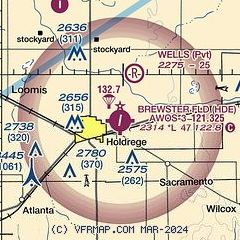
|
| Airport distance calculator |
|---|
|
|
| Sunrise and sunset |
|---|
|
Times for 15-Jan-2026
| | Local
(UTC-6) | | Zulu
(UTC) |
|---|
| Morning civil twilight | | 07:30 | | 13:30 |
| Sunrise | | 08:00 | | 14:00 |
| Sunset | | 17:34 | | 23:34 |
| Evening civil twilight | | 18:04 | | 00:04 |
|
| Current date and time |
|---|
| Zulu (UTC) | 15-Jan-2026 17:01:02 |
|---|
| Local (UTC-6) | 15-Jan-2026 11:01:02 |
|---|
|
| METAR |
|---|
| KHDE | 151635Z AUTO 27009KT 10SM CLR 03/M02 A2982 RMK AO2 T00281023
|
|
| TAF |
|---|
KEAR
22nm NE | 151120Z 1512/1612 21008KT P6SM FEW240 FM151600 26012G20KT P6SM BKN240 FM151800 31018G29KT P6SM BKN250 FM160000 32011KT P6SM FEW250 FM160200 34017G27KT P6SM VCSH SCT050 SCT180 FM160900 31020G34KT P6SM SCT150
|
|
| NOTAMs |
|---|
NOTAMs are issued by the DoD/FAA and will open in a separate window not controlled by AirNav.
|
|

