FAA INFORMATION EFFECTIVE 10 JULY 2025
Location
| FAA Identifier: | HDO |
| Lat/Long: | 29-21-32.8700N 099-10-38.9700W
29-21.547833N 099-10.649500W
29.3591306,-99.1774917
(estimated) |
| Elevation: | 930.1 ft. / 283.5 m (surveyed) |
| Variation: | 08E (1980) |
| From city: | 2 miles NW of HONDO, TX |
| Time zone: | UTC -5 (UTC -6 during Standard Time) |
| Zip code: | 78861 |
Airport Operations
| Airport use: | Open to the public |
| Activation date: | 07/1943 |
| Control tower: | no |
| ARTCC: | HOUSTON CENTER |
| FSS: | SAN ANGELO FLIGHT SERVICE STATION |
| NOTAMs facility: | HDO (NOTAM-D service available) |
| Attendance: | MON-FRI 0730-1700 |
| Pattern altitude: | 1730.1 ft. MSL |
| Wind indicator: | lighted |
| Segmented circle: | yes |
| Lights: | SS-SR |
| Beacon: | white-green (lighted land airport)
Operates sunset to sunrise. |
Airport Communications
| CTAF/UNICOM: | 122.725 |
| WX ASOS: | 119.675 (830-426-3060) |
| WX AWOS-3 at CVB (17 nm E): | 119.25 (830-931-0232) |
- APCH/DEP CTL SVC PRVDD BY HOUSTON ARTCC (ZHU) ON FREQS 134.95/ 269.4 (KERRVILLE RCAG).
Nearby radio navigation aids
| VOR radial/distance | | VOR name | | Freq | | Var |
|---|
| CSIr169/33.8 | | CENTER POINT VORTAC | | 117.50 | | 08E |
| SSFr270/(38.9) | | STINSON VOR | | 108.40 | | 09E |
| NDB name | | Hdg/Dist | | Freq | | Var | | ID |
|---|
| DEVINE | | 310/18.2 | | 359 | | 07E | | HHH | .... .... .... |
Airport Services
| Fuel available: | 100LL JET-A
100LL:FUEL 24 HR SELF SERVE. FULL SERVE JET A & AVGAS ON REQUEST, 830-426-3810. 2 HR PRIOR NOTICE, AFT HRS. |
| Parking: | hangars and tiedowns |
| Airframe service: | MINOR |
| Powerplant service: | MINOR |
Runway Information
Runway 17L/35R
| Dimensions: | 6002 x 100 ft. / 1829 x 30 m |
| Surface: | concrete, in good condition |
| Weight bearing capacity: | | PCN 103/R/C/W/T | | Single wheel: | 30.0 | | Double wheel: | 45.0 | | Double tandem: | 90.0 |
|
| Runway edge lights: | medium intensity |
| RUNWAY 17L | | RUNWAY 35R |
| Latitude: | 29-22.046650N | | 29-21.056400N |
| Longitude: | 099-10.321217W | | 099-10.320583W |
| Elevation: | 929.4 ft. | | 911.7 ft. |
| Traffic pattern: | left | | right |
| Runway heading: | 172 magnetic, 180 true | | 352 magnetic, 360 true |
| Markings: | nonprecision, in good condition | | nonprecision, in good condition |
| Visual slope indicator: | 4-light PAPI on left (3.00 degrees glide path) | | 4-light PAPI on left (3.00 degrees glide path) |
| Touchdown point: | yes, no lights | | yes, no lights |
Runway 13/31
| Dimensions: | 5545 x 150 ft. / 1690 x 46 m |
| Surface: | concrete, in excellent condition |
| Weight bearing capacity: | | Single wheel: | 30.0 | | Double wheel: | 45.0 | | Double tandem: | 90.0 |
|
| RUNWAY 13 | | RUNWAY 31 |
| Latitude: | 29-21.703000N | | 29-21.056500N |
| Longitude: | 099-11.097167W | | 099-10.358333W |
| Elevation: | 927.3 ft. | | 912.0 ft. |
| Traffic pattern: | right | | left |
| Runway heading: | 127 magnetic, 135 true | | 307 magnetic, 315 true |
| Displaced threshold: | 98 ft. | | no |
| Markings: | nonprecision, in good condition | | nonprecision, in good condition |
| Touchdown point: | yes, no lights | | yes, no lights |
Runway 8/26
| Dimensions: | 3451 x 75 ft. / 1052 x 23 m
RWY WID IS 75 FT AND UNMKD; OVERALL PAVEMENT WID IS 150 FT. |
| Surface: | concrete, in good condition |
| Weight bearing capacity: | | Single wheel: | 30.0 | | Double wheel: | 45.0 | | Double tandem: | 90.0 |
|
| RUNWAY 8 | | RUNWAY 26 |
| Latitude: | 29-21.842167N | | 29-21.842500N |
| Longitude: | 099-11.095000W | | 099-10.445000W |
| Elevation: | 930.1 ft. | | 926.0 ft. |
| Traffic pattern: | left | | left |
| Runway heading: | 082 magnetic, 090 true | | 262 magnetic, 270 true |
| Markings: | basic, in good condition | | basic, in good condition |
| Touchdown point: | yes, no lights | | yes, no lights |
Runway 17R/35L
| Dimensions: | 3224 x 140 ft. / 983 x 43 m |
| Surface: | asphalt, in good condition |
| Weight bearing capacity: | | Single wheel: | 30.0 | | Double wheel: | 45.0 | | Double tandem: | 90.0 |
|
| Operational restrictions: | CLSD TO ACFT OVER 12500 LBS. |
| RUNWAY 17R | | RUNWAY 35L |
| Latitude: | 29-21.780617N | | 29-21.248700N |
| Longitude: | 099-10.998000W | | 099-10.997800W |
| Elevation: | 927.9 ft. | | 916.9 ft. |
| Traffic pattern: | right | | left |
| Runway heading: | 172 magnetic, 180 true | | 352 magnetic, 360 true |
| Markings: | nonprecision, in good condition | | nonprecision, in good condition |
| Touchdown point: | yes, no lights | | yes, no lights |
Airport Ownership and Management from official FAA records
| Ownership: | Publicly-owned |
| Owner: | CITY OF HONDO
1600 AVENUE M
HONDO, TX 78861
Phone 830-426-3378 |
| Manager: | RYAN ELDER
700 VANDENBERG RD
HONDO, TX 78861
Phone 830-426-3810 |
Additional Remarks
| - | DEER ON & INVOF ARPT. |
| - | FOR CD CTC HOUSTON ARTCC AT 281-230-5622. |
Instrument Procedures
NOTE: All procedures below are presented as PDF files. If you need a reader for these files, you should download the free Adobe Reader.NOT FOR NAVIGATION. Please procure official charts for flight.
FAA instrument procedures published for use from 10 July 2025 at 0901Z to 07 August 2025 at 0900z.
IAPs - Instrument Approach Procedures |
|---|
| RNAV (GPS) RWY 17L | |
download (276KB) |
| RNAV (GPS) RWY 35R | |
download (249KB) |
| NOTE: Special Alternate Minimums apply | |
download (123KB) |
| NOTE: Special Take-Off Minimums/Departure Procedures apply | |
download (105KB) |
Other nearby airports with instrument procedures:
KCVB - Castroville Municipal Airport (17 nm E)
23R - Devine Municipal Airport (18 nm SE)
KUVA - Garner Field Airport (31 nm W)
KSKF - Kelly Field Airport (31 nm E)
T30 - Mc Kinley Field Airport (32 nm S)
|
|

Road maps at:
MapQuest
Bing
Google
| Aerial photo |
|---|
WARNING: Photo may not be current or correct
 Photo by John D. Trolinger
Photo taken 02-Nov-2018
looking north.
Photo by John D. Trolinger
Photo taken 02-Nov-2018
looking north.
Do you have a better or more recent aerial photo of South Texas Regional Airport at Hondo that you would like to share? If so, please send us your photo.
|
| Sectional chart |
|---|
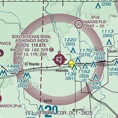
|
| Airport distance calculator |
|---|
|
|
| Sunrise and sunset |
|---|
|
Times for 15-Jul-2025
| | Local
(UTC-5) | | Zulu
(UTC) |
|---|
| Morning civil twilight | | 06:22 | | 11:22 |
| Sunrise | | 06:48 | | 11:48 |
| Sunset | | 20:37 | | 01:37 |
| Evening civil twilight | | 21:04 | | 02:04 |
|
| Current date and time |
|---|
| Zulu (UTC) | 15-Jul-2025 13:26:01 |
|---|
| Local (UTC-5) | 15-Jul-2025 08:26:01 |
|---|
|
| METAR |
|---|
| KHDO | 151251Z AUTO 14009KT 10SM OVC013 26/24 A3004 RMK AO2 SLP154 T02610239
|
KCVB
17nm E | 151255Z AUTO 12005KT 10SM SCT010 BKN017 27/25 A3003 RMK AO2
|
|
| TAF |
|---|
KSKF
32nm E | 151000Z 1510/1616 14007KT 9999 SCT012 SCT024 BKN080 QNH2996INS TEMPO 1510/1515 BKN012 OVC020 BECMG 1514/1515 17010G15KT 9999 SCT030 SCT150 QNH2990INS BECMG 1520/1521 15012G20KT 9999 BKN050 BKN150 QNH2985INS BECMG 1603/1604 14006KT 9999 FEW025 SCT050 SCT150 QNH2987INS BECMG 1605/1606 16006KT 9999 BKN013 OVC030 QNH2988INS BECMG 1613/1614 16009KT 9999 SCT030 QNH2991INS TX34/1522Z TN24/1511Z
|
KSSF
37nm E | 151130Z 1512/1612 15004KT P6SM BKN019 BKN080 FM151600 15010KT P6SM SCT050 SCT200 FM152200 14010G20KT P6SM SCT050 SCT200
|
KSAT
39nm E | 151130Z 1512/1618 14009KT P6SM BKN014 OVC070 FM151600 14011KT P6SM SCT050 SCT200 FM152100 15011G21KT P6SM SCT050 SCT200 FM160500 14012KT P6SM SCT050 SCT200 FM160800 15011KT P6SM OVC019
|
|
| NOTAMs |
|---|
NOTAMs are issued by the DoD/FAA and will open in a separate window not controlled by AirNav.
|
|


