FAA INFORMATION EFFECTIVE 14 MAY 2026
Location
| FAA Identifier: | HHG |
| Lat/Long: | 40-51-10.5000N 085-27-25.4000W
40-51.175000N 085-27.423333W
40.8529167,-85.4570556
(estimated) |
| Elevation: | 805.7 ft. / 245.6 m (surveyed) |
| Variation: | 06W (2025) |
| From city: | 3 miles SE of HUNTINGTON, IN |
| Time zone: | UTC -4 (UTC -5 during Standard Time) |
| Zip code: | 46750 |
Airport Operations
| Airport use: | Open to the public |
| Activation date: | 12/1942 |
| Control tower: | no |
| ARTCC: | CHICAGO CENTER |
| FSS: | TERRE HAUTE FLIGHT SERVICE STATION |
| NOTAMs facility: | HUF (NOTAM-D service available) |
| Attendance: | SUN 1200-1700, ALL MON - SAT 0800-1700
UNATNDD HOLIDAYS. |
| Wind indicator: | lighted |
| Segmented circle: | no |
| Lights: | ACTVT REIL RWY 10 & 28; MIRL RWY 1028 - CTAF. MIRL RWY 10/28 PRESET LOW INTST; INCR INTST - CTAF. |
| Beacon: | white-green (lighted land airport)
Operates sunset to sunrise. |
Airport Communications
| CTAF/UNICOM: | 122.8 |
| WX AWOS-3PT: | 126.575 (260-454-1927) |
| FORT WAYNE APPROACH: | 127.2 |
| FORT WAYNE DEPARTURE: | 127.2 |
| WX ASOS at FWA (14 nm NE): | PHONE 260-209-0224 |
Nearby radio navigation aids
| VOR radial/distance | | VOR name | | Freq | | Var |
|---|
| FWAr244/14.4 | | FORT WAYNE VORTAC | | 117.80 | | 06W |
| OLKr179/(23.7) | | WEBSTER LAKE VOR | | 110.40 | | 03W |
| MZZr028/23.8 | | MARION VOR/DME | | 108.60 | | 03W |
Airport Services
| Fuel available: | 100LL JET-A
100LL:SELF SVC AVBL. |
| Parking: | hangars and tiedowns |
| Airframe service: | MAJOR |
| Powerplant service: | MAJOR |
| Bottled oxygen: | NONE |
| Bulk oxygen: | NONE |
Runway Information
Runway 10/28
| Dimensions: | 5003 x 75 ft. / 1525 x 23 m |
| Surface: | asphalt/grooved, in good condition |
| Weight bearing capacity: | | Single wheel: | 38.0 | | Double wheel: | 50.0 |
|
| Runway edge lights: | medium intensity |
| RUNWAY 10 | | RUNWAY 28 |
| Latitude: | 40-51.190970N | | 40-51.159273N |
| Longitude: | 085-27.966082W | | 085-26.881865W |
| Elevation: | 804.8 ft. | | 804.2 ft. |
| Traffic pattern: | left | | left |
| Runway heading: | 098 magnetic, 092 true | | 278 magnetic, 272 true |
| Markings: | nonprecision, in good condition | | nonprecision, in good condition |
| Visual slope indicator: | 2-light PAPI on left (3.00 degrees glide path) | | 2-light PAPI on left (3.00 degrees glide path) |
| Runway end identifier lights: | yes | | yes |
| Touchdown point: | yes, no lights | | yes, no lights |
| Obstructions: | 33 ft. trees, 300 ft. from runway, 240 ft. right of centerline, 3:1 slope to clear | | 55 ft. trees, 1100 ft. from runway, 16:1 slope to clear |
Airport Ownership and Management from official FAA records
| Ownership: | Publicly-owned |
| Owner: | HUNTINGTON BOAC
1365 WARREN RD
HUNTINGTON, IN 46750
Phone 260-356-8515 |
| Manager: | SCOTT NICOLA
1365 WARREN RD
HUNTINGTON, IN 46750
Phone 260-356-8515 |
Additional Remarks
| - | DEER ON & INVOF ARPT SPCLY MORNING & EVE. |
| - | FOR CD CTC CHICAGO ARTCC AT 630-906-8921. |
Instrument Procedures
NOTE: All procedures below are presented as PDF files. If you need a reader for these files, you should download the free Adobe Reader.NOT FOR NAVIGATION. Please procure official charts for flight.
FAA instrument procedures published for use from 14 May 2026 at 0901Z to 11 June 2026 at 0900Z.
IAPs - Instrument Approach Procedures |
|---|
| RNAV (GPS) RWY 10 | |
download (172KB) |
| RNAV (GPS) RWY 28 **CHANGED** | |
download (183KB) |
| NOTE: Special Alternate Minimums apply **CHANGED** | |
download (150KB) |
| NOTE: Special Take-Off Minimums/Departure Procedures apply | |
download (467KB) |
Other nearby airports with instrument procedures:
KFWA - Fort Wayne International Airport (14 nm NE)
KIWH - Wabash Municipal Airport (16 nm W)
KSMD - Smith Field Airport (22 nm NE)
KMZZ - Marion Municipal Airport - McKinney Field (24 nm SW)
KASW - Warsaw Municipal Airport (31 nm NW)
|
|

Road maps at:
MapQuest
Bing
Google
| Aerial photo |
|---|
WARNING: Photo may not be current or correct
 Photo courtesy of AirNav, LLC
Photo taken 17-Oct-2011
looking west.
Photo courtesy of AirNav, LLC
Photo taken 17-Oct-2011
looking west.
Do you have a better or more recent aerial photo of Huntington Municipal Airport that you would like to share? If so, please send us your photo.
|
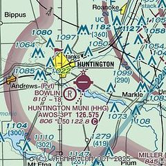
| Sectional chart |
|---|
|
| Airport distance calculator |
|---|
|
|
| Sunrise and sunset |
|---|
|
Times for 30-May-2026
| | Local
(UTC-4) | | Zulu
(UTC) |
|---|
| Morning civil twilight | | 05:42 | | 09:42 |
| Sunrise | | 06:14 | | 10:14 |
| Sunset | | 21:04 | | 01:04 |
| Evening civil twilight | | 21:37 | | 01:37 |
|
| Current date and time |
|---|
| Zulu (UTC) | 31-May-2026 02:01:45 |
|---|
| Local (UTC-4) | 30-May-2026 22:01:45 |
|---|
|
| METAR |
|---|
| KHHG | 310155Z AUTO 08005KT 10SM CLR 15/04 A3014 RMK AO2 T01490037
|
KFWA
14nm NE | 310154Z 07010KT 10SM BKN250 15/03 A3015 RMK AO2 SLP207 T01500033
|
|
| TAF |
|---|
KFWA
14nm NE | 301720Z 3018/3118 07014G22KT P6SM SCT250 FM310200 09007KT P6SM SCT250
|
|
| NOTAMs |
|---|
NOTAMs are issued by the DoD/FAA and will open in a separate window not controlled by AirNav.
|
|


