FAA INFORMATION EFFECTIVE 09 JULY 2026
Location
| FAA Identifier: | ASW |
| Lat/Long: | 41-16-28.9000N 085-50-24.3000W
41-16.481667N 085-50.405000W
41.2746944,-85.8400833
(estimated) |
| Elevation: | 849.7 ft. / 259.0 m (surveyed) |
| Variation: | 03W (1985) |
| From city: | 2 miles N of WARSAW, IN |
| Time zone: | UTC -4 (UTC -5 during Standard Time) |
| Zip code: | 46582 |
Airport Operations
| Airport use: | Open to the public |
| Activation date: | 09/1947 |
| Control tower: | no |
| ARTCC: | CHICAGO CENTER |
| FSS: | TERRE HAUTE FLIGHT SERVICE STATION |
| NOTAMs facility: | ASW (NOTAM-D service available) |
| Attendance: | MON-FRI 0700-1900, ALL SAT-SUN 0800-1800
AFT HR - 574-372-9541 |
| Wind indicator: | lighted |
| Segmented circle: | yes |
| Lights: | ACTVT REIL RWY 09 & 27; PAPI RWY 09 & 27; MIRL RWY 18/36 - CTAF. VASI RWY 18 OPR CONSLY. HIRL RWY 09/27 PRESET TO LOW INTST; INCR INTST - CTAF. |
| Beacon: | white-green (lighted land airport)
Operates sunset to sunrise. |
Airport Communications
| CTAF/UNICOM: | 122.7 |
| WX AWOS-3: | 121.125 (574-269-7035) |
| FORT WAYNE APPROACH: | 127.2 |
| FORT WAYNE DEPARTURE: | 127.2 |
| CLEARANCE DELIVERY: | 134.05 |
| WX ASOS at GSH (15 nm N): | 121.45 (574-642-4231) |
| WX AWOS-3 at RCR (20 nm SW): | 118.775 (574-223-3560) |
- APCH CTL SECTORIZATION BASED UPON FORT WAYNE RWY USAGE.
Nearby radio navigation aids
| VOR radial/distance | | VOR name | | Freq | | Var |
|---|
| OLKr279/(15.5) | | WEBSTER LAKE VOR | | 110.40 | | 03W |
| FWAr307/34.4 | | FORT WAYNE VORTAC | | 117.80 | | 06W |
| GIJr144/36.6 | | GIPPER VORTAC | | 115.40 | | 00E |
| NDB name | | Hdg/Dist | | Freq | | Var | | ID |
|---|
| STURGIS | | 213/37.1 | | 382 | | 04W | | IRS | .. .-. ... |
Airport Services
| Fuel available: | 100LL JET-A |
| Parking: | hangars and tiedowns |
| Airframe service: | MAJOR |
| Powerplant service: | MAJOR |
Runway Information
Runway 9/27
| Dimensions: | 6001 x 100 ft. / 1829 x 30 m |
| Surface: | asphalt/grooved, in good condition |
| Weight bearing capacity: | | Single wheel: | 46.0 | | Double wheel: | 75.0 |
|
| Runway edge lights: | high intensity |
| RUNWAY 9 | | RUNWAY 27 |
| Latitude: | 41-16.344467N | | 41-16.364858N |
| Longitude: | 085-50.773998W | | 085-49.464435W |
| Elevation: | 837.4 ft. | | 849.5 ft. |
| Traffic pattern: | left | | left |
| Runway heading: | 092 magnetic, 089 true | | 272 magnetic, 269 true |
| Displaced threshold: | no | | 901 ft. |
| Declared distances: | TORA:5100 TODA:5100 ASDA:5100 LDA:5100 | | TORA:6000 TODA:6000 ASDA:6000 LDA:5100 |
| Markings: | nonprecision, in fair condition | | precision, in fair condition |
| Visual slope indicator: | 2-light PAPI on left (3.00 degrees glide path) | | 4-light PAPI on left (3.00 degrees glide path) |
| Runway end identifier lights: | yes | | yes |
| Touchdown point: | yes, no lights | | yes, no lights |
| Instrument approach: | | | ILS/DME |
| Obstructions: | 41 ft. pole, 1460 ft. from runway, 10 ft. right of centerline, 30:1 slope to clear | | 166 ft. tower, lighted, 5600 ft. from runway, 200 ft. right of centerline, 32:1 slope to clear
6 FT FENCE 1045 FT FM RWY END; 15 FT ROAD 1070 FT FM RWY END. |
Runway 18/36
| Dimensions: | 4021 x 75 ft. / 1226 x 23 m |
| Surface: | asphalt, in fair condition |
| Weight bearing capacity: | |
| Runway edge lights: | medium intensity |
| RUNWAY 18 | | RUNWAY 36 |
| Latitude: | 41-17.003283N | | 41-16.341305N |
| Longitude: | 085-50.836305W | | 085-50.823785W |
| Elevation: | 839.7 ft. | | 836.5 ft. |
| Traffic pattern: | left | | left |
| Runway heading: | 182 magnetic, 179 true | | 002 magnetic, 359 true |
| Markings: | nonprecision, in fair condition | | nonprecision, in fair condition |
| Visual slope indicator: | 4-box VASI on left (3.50 degrees glide path) | | |
| Touchdown point: | yes, no lights | | yes, no lights |
| Obstructions: | 15 ft. road, 495 ft. from runway, 19:1 slope to clear | | 28 ft. tree, 1000 ft. from runway, 165 ft. left of centerline, 28:1 slope to clear |
Airport Ownership and Management from official FAA records
| Ownership: | Publicly-owned |
| Owner: | WARSAW BOAC
3000 AIRPORT DR
WARSAW, IN 46582
Phone 574-269-1337 |
| Manager: | NICHOLAS KING
3000 AIRPORT DR
WARSAW, IN 46582
Phone 574-269-1337 |
Additional Remarks
| - | FOR CD CTC CHICAGO ARTCC AT 630-906-8921. |
Instrument Procedures
NOTE: All procedures below are presented as PDF files. If you need a reader for these files, you should download the free Adobe Reader.NOT FOR NAVIGATION. Please procure official charts for flight.
FAA instrument procedures published for use from 09 July 2026 at 0901Z to 06 August 2026 at 0900Z.
IAPs - Instrument Approach Procedures |
|---|
| ILS OR LOC RWY 27 | |
download (191KB) |
| RNAV (GPS) RWY 09 | |
download (222KB) |
| RNAV (GPS) RWY 27 | |
download (212KB) |
| NOTE: Special Alternate Minimums apply | |
download (143KB) |
| NOTE: Special Take-Off Minimums/Departure Procedures apply | |
download (545KB) |
Other nearby airports with instrument procedures:
C03 - Nappanee Municipal Airport (11 nm NW)
KGSH - Goshen Municipal Airport (15 nm N)
KRCR - Fulton County Airport (20 nm SW)
C65 - Plymouth Municipal Airport (21 nm W)
KEKM - Elkhart Municipal Airport (28 nm N)
|
|

Road maps at:
MapQuest
Bing
Google
| Aerial photo |
|---|
WARNING: Photo may not be current or correct
 Photo by Pascal Nguyen
Photo taken 07-Mar-2006
Photo by Pascal Nguyen
Photo taken 07-Mar-2006
Do you have a better or more recent aerial photo of Warsaw Municipal Airport that you would like to share? If so, please send us your photo.
|
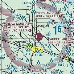
| Sectional chart |
|---|
|
| Airport distance calculator |
|---|
|
|
| Sunrise and sunset |
|---|
|
Times for 14-Jul-2026
| | Local
(UTC-4) | | Zulu
(UTC) |
|---|
| Morning civil twilight | | 05:51 | | 09:51 |
| Sunrise | | 06:23 | | 10:23 |
| Sunset | | 21:15 | | 01:15 |
| Evening civil twilight | | 21:48 | | 01:48 |
|
| Current date and time |
|---|
| Zulu (UTC) | 15-Jul-2026 03:03:12 |
|---|
| Local (UTC-4) | 14-Jul-2026 23:03:12 |
|---|
|
| METAR |
|---|
| KASW | 150255Z AUTO 00000KT 10SM CLR 25/21 A3014 RMK AO2 T02550216
|
KGSH
16nm N | 150253Z AUTO 00000KT 10SM CLR 25/23 A3013 RMK AO2 SLP196 60000 T02500233 53005
|
KRCR
20nm SW | 150235Z AUTO 9SM BKN060 27/23 A3013 RMK AO2
|
|
| TAF |
|---|
KSBN
33nm NW | 141720Z 1418/1518 29005KT P6SM SKC FM150000 VRB03KT P6SM SKC
|
KFWA
34nm SE | 141720Z 1418/1518 25006KT P6SM BKN300 FM150300 VRB03KT P6SM SKC
|
KGUS
41nm S | 142100Z 1421/1603 VRB06KT 9999 FEW040 SCT250 QNH3001INS TEMPO 1508/1512 3200 BR TX34/1521Z TN21/1510Z LAST NO AMDS AFT 1503 NEXT 1513
|
|
| NOTAMs |
|---|
NOTAMs are issued by the DoD/FAA and will open in a separate window not controlled by AirNav.
|
|

