FAA INFORMATION EFFECTIVE 09 JULY 2026
Location
| FAA Identifier: | I66 |
| Lat/Long: | 39-30-08.9210N 083-51-47.9190W
39-30.148683N 083-51.798650W
39.5024781,-83.8633108
(estimated) |
| Elevation: | 1033.1 ft. / 314.9 m (surveyed) |
| Variation: | 05W (2000) |
| From city: | 4 miles NW of WILMINGTON, OH |
| Time zone: | UTC -4 (UTC -5 during Standard Time) |
| Zip code: | 45177 |
Airport Operations
| Airport use: | Open to the public |
| Control tower: | no |
| ARTCC: | INDIANAPOLIS CENTER |
| FSS: | DAYTON FLIGHT SERVICE STATION |
| NOTAMs facility: | DAY (NOTAM-D service available) |
| Attendance: | UNATNDD |
| Wind indicator: | lighted |
| Segmented circle: | no |
| Lights: | ACTVT MIRL RWY 03/21 - CTAF. PAPI RWY 03 & 21 OPR CONSLY. |
| Beacon: | white-green (lighted land airport)
Operates sunset to sunrise. |
Airport Communications
| CTAF/UNICOM: | 122.725 |
| WX AWOS-3: | 124.175 (937-382-1376) |
| COLUMBUS APPROACH: | 118.85 |
| COLUMBUS DEPARTURE: | 118.85 |
| WX ASOS at ILN (6 nm SE): | PHONE 937-347-3258 |
| WX AWOS-3 at GDK (13 nm NW): | 118.525 (937-372-4668) |
| WX ASOS at MGY (18 nm W): | 118.375 (937-885-2171) |
| WX AWOS-3PT at I68 (18 nm W): | 120.55 (513-934-5500) |
Nearby radio navigation aids
| VOR radial/distance | | VOR name | | Freq | | Var |
|---|
| MXQr331/5.2 | | MIDWEST VOR/DME | | 112.90 | | 04W |
| DQNr142/39.5 | | DAYTON VOR/DME | | 114.50 | | 01W |
| NDB name | | Hdg/Dist | | Freq | | Var | | ID |
|---|
| AIRBO | | 283/5.8 | | 407 | | 07W | | IL | .. .-.. |
| CUBLA | | 011/9.0 | | 299 | | 07W | | HW | .... .-- |
| COURT HOUSE | | 261/22.6 | | 414 | | 06W | | CSS | -.-. ... ... |
| SPORTYS | | 037/30.3 | | 245 | | 04W | | PWF | .--. .-- ..-. |
Airport Services
| Fuel available: | 100LL
100LL:AVBL SELF SVC VIA CREDIT CARD ONLY. |
| Parking: | hangars and tiedowns |
| Airframe service: | NONE |
| Powerplant service: | NONE |
| Bottled oxygen: | NONE |
| Bulk oxygen: | NONE |
Runway Information
Runway 3/21
| Dimensions: | 3579 x 60 ft. / 1091 x 18 m |
| Surface: | asphalt, in excellent condition |
| Weight bearing capacity: | |
| Runway edge lights: | medium intensity |
| RUNWAY 3 | | RUNWAY 21 |
| Latitude: | 39-29.889113N | | 39-30.408257N |
| Longitude: | 083-51.978955W | | 083-51.618337W |
| Elevation: | 1025.2 ft. | | 1030.7 ft. |
| Traffic pattern: | left | | left |
| Runway heading: | 033 magnetic, 028 true | | 213 magnetic, 208 true |
| Markings: | nonprecision, in good condition | | nonprecision, in good condition |
| Visual slope indicator: | 2-light PAPI on left (3.00 degrees glide path) | | 2-light PAPI on left (3.75 degrees glide path) |
| Runway end identifier lights: | no | | no |
| Touchdown point: | yes, no lights | | yes, no lights |
| Obstructions: | 55 ft. trees, 460 ft. from runway, 256 ft. right of centerline, 4:1 slope to clear | | 30 ft. tree, 281 ft. from runway, 250 ft. left of centerline, 2:1 slope to clear
+70 FT TREE, 94 FT DIST, 220 FT L. |
Airport Ownership and Management from official FAA records
| Ownership: | Publicly-owned |
| Owner: | CLINTON CO BOARD OF COMM
1850 DAVIDS DR STE 208
WILMINGTON, OH 45177-7205
Phone 937-382-2103 |
| Manager: | MELODY WALDMANN
1581 N CURRY RD
WILMINGTON, OH 45177-9048
Phone 937-382-4638
CELL 937-725-1946. |
Additional Remarks
| - | DEER & BIRDS ON & INVOF ARPT. |
| - | FOR CD CTC COLUMBUS APCH AT 614-338-8537. |
Instrument Procedures
NOTE: All procedures below are presented as PDF files. If you need a reader for these files, you should download the free Adobe Reader.NOT FOR NAVIGATION. Please procure official charts for flight.
FAA instrument procedures published for use from 09 July 2026 at 0901Z to 06 August 2026 at 0900Z.
IAPs - Instrument Approach Procedures |
|---|
| RNAV (GPS) RWY 03 | |
download (200KB) |
| RNAV (GPS) RWY 21 | |
download (223KB) |
| NOTE: Special Take-Off Minimums/Departure Procedures apply | |
download (460KB) |
Other nearby airports with instrument procedures:
KILN - Wilmington Air Park (6 nm SE)
KGDK - Greene County/Lewis A Jackson Regional Airport (13 nm NW)
KMGY - Dayton/Wright Brothers Airport (18 nm W)
I68 - Warren County Airport/John Lane Field (18 nm W)
KSGH - Springfield/Beckley Municipal Airport (20 nm N)
|
|

Road maps at:
MapQuest
Bing
Google
| Aerial photo |
|---|
WARNING: Photo may not be current or correct
 Photo by Matthew T. Ross
Photo taken 20-Mar-2012
looking west from a Cessna 172F.
Photo by Matthew T. Ross
Photo taken 20-Mar-2012
looking west from a Cessna 172F.
Do you have a better or more recent aerial photo of Clinton Field Airport that you would like to share? If so, please send us your photo.
|
| Sectional chart |
|---|
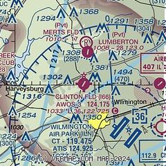
|
| Airport distance calculator |
|---|
|
|
| Sunrise and sunset |
|---|
|
Times for 26-Jul-2026
| | Local
(UTC-4) | | Zulu
(UTC) |
|---|
| Morning civil twilight | | 06:00 | | 10:00 |
| Sunrise | | 06:31 | | 10:31 |
| Sunset | | 20:53 | | 00:53 |
| Evening civil twilight | | 21:24 | | 01:24 |
|
| Current date and time |
|---|
| Zulu (UTC) | 26-Jul-2026 15:09:32 |
|---|
| Local (UTC-4) | 26-Jul-2026 11:09:32 |
|---|
|
| METAR |
|---|
KILN
5nm SE | 261454Z AUTO VRB03KT 10SM SCT015 BKN032 23/19 A2999 RMK AO2 SLP148 T02330194 58002
|
KMGY
18nm W | 261453Z AUTO 00000KT 10SM OVC018 22/19 A2999 RMK AO2 SLP148 T02220189 58004
|
KI68
18nm W | 261455Z AUTO 26004KT 10SM BKN014 OVC018 22/20 A2998 RMK AO2
|
KSGH
19nm N | 261456Z AUTO VRB04KT 10SM BKN014 OVC032 23/19 A2999 RMK AO2 SLP152 T02280189 58002
|
|
| TAF |
|---|
KILN
5nm SE | 261139Z 2612/2712 28005KT P6SM OVC035 TEMPO 2612/2616 OVC025 FM261600 28007KT P6SM BKN035 FM270200 24005KT P6SM SCT250 FM270800 00000KT 3SM BR SCT250 TEMPO 2708/2712 2SM BR
|
|
| NOTAMs |
|---|
NOTAMs are issued by the DoD/FAA and will open in a separate window not controlled by AirNav.
|
|


