FAA INFORMATION EFFECTIVE 16 APRIL 2026
Location
| FAA Identifier: | GDK |
| Lat/Long: | 39-41-26.6000N 083-59-34.0000W
39-41.443333N 083-59.566667W
39.6907222,-83.9927778
(estimated) |
| Elevation: | 948.5 ft. / 289.1 m (surveyed) |
| Variation: | 05W (1995) |
| From city: | 10 miles E of DAYTON, OH |
| Time zone: | UTC -4 (UTC -5 during Standard Time) |
| Zip code: | 45385 |
Airport Operations
| Airport use: | Open to the public |
| Activation date: | 10/1968 |
| Control tower: | no |
| ARTCC: | INDIANAPOLIS CENTER |
| FSS: | DAYTON FLIGHT SERVICE STATION |
| NOTAMs facility: | GDK (NOTAM-D service available) |
| Attendance: | NOV-MAR 0800-1800, APR-OCT 0800-2000
UNATNDD THANKSGIVING, CHRISTMAS, & NEW YEARS DAY. |
| Wind indicator: | lighted |
| Segmented circle: | no |
| Lights: | ACTVT REIL RWY 07 & 25; MIRL RWY 07/25 - CTAF. PAPI RWY 07 & 25 OPR CONSLY. |
| Beacon: | white-green (lighted land airport)
Operates sunset to sunrise. |
Airport Communications
| CTAF/UNICOM: | 122.725 |
| WX AWOS-3: | 118.525 (937-372-4668) |
| COLUMBUS APPROACH: | 118.85 |
| COLUMBUS DEPARTURE: | 118.85 |
| WX AWOS-3PT at SGH (11 nm NE): | 134.975 (937-324-4532) |
| WX ASOS at MGY (12 nm SW): | 118.375 (937-885-2171) |
| WX AWOS-3 at I66 (13 nm SE): | 124.175 (937-382-1376) |
| WX ASOS at DAY (16 nm NW): | PHONE 937-419-1421 |
| WX AWOS-3PT at I68 (18 nm SW): | 120.55 (513-934-5500) |
| WX ASOS at ILN (18 nm SE): | PHONE 937-383-7334 |
Nearby radio navigation aids
| VOR radial/distance | | VOR name | | Freq | | Var |
|---|
| MXQr335/18.0 | | MIDWEST VOR/DME | | 112.90 | | 04W |
| DQNr137/27.0 | | DAYTON VOR/DME | | 114.50 | | 01W |
| RODr181/35.9 | | ROSEWOOD VORTAC | | 117.50 | | 05W |
| NDB name | | Hdg/Dist | | Freq | | Var | | ID |
|---|
| COURT HOUSE | | 287/28.3 | | 414 | | 06W | | CSS | -.-. ... ... |
| SPORTYS | | 020/38.3 | | 245 | | 04W | | PWF | .--. .-- ..-. |
Airport Services
| Fuel available: | 100LL JET-A
100LL:100LL & JET A AVBL H24 SELF SVC VIA CREDIT CARD.
A:ANTI-ICING AVBL AT NOZZLE. |
| Parking: | hangars and tiedowns |
| Airframe service: | MAJOR |
| Powerplant service: | MAJOR |
| Bottled oxygen: | NONE |
| Bulk oxygen: | HIGH |
Runway Information
Runway 7/25
| Dimensions: | 5004 x 75 ft. / 1525 x 23 m |
| Surface: | asphalt, in good condition |
| Weight bearing capacity: | |
| Runway edge lights: | medium intensity |
| RUNWAY 7 | | RUNWAY 25 |
| Latitude: | 39-41.256342N | | 39-41.629478N |
| Longitude: | 084-00.042808W | | 083-59.091673W |
| Elevation: | 909.5 ft. | | 948.5 ft. |
| Traffic pattern: | left | | left |
| Runway heading: | 068 magnetic, 063 true | | 248 magnetic, 243 true |
| Markings: | nonprecision, in good condition | | nonprecision, in good condition |
| Visual slope indicator: | 2-light PAPI on left (3.50 degrees glide path) | | 2-light PAPI on left (3.50 degrees glide path) |
| Runway end identifier lights: | yes | | yes |
| Touchdown point: | yes, no lights | | yes, no lights |
Airport Ownership and Management from official FAA records
| Ownership: | Publicly-owned |
| Owner: | GREENE COUNTY RGNL ARPT AUTH
140 N VALLEY RD
XENIA, OH 45385-9301
Phone 937-376-8107 |
| Manager: | ALEXANDREA BARRETT
140 N VALLEY RD
XENIA, OH 45385-9301
Phone 937-376-8107 |
Additional Remarks
| A58-07 | 5-10 FT BRUSH, 0-150 FT DIST, 150 FT L; 5-10 FT BRUSH, 0-50 FT DIST, 230 FT R. |
| - | DEER, BIRDS, & OTR WILDLIFE ON & INVOF ARPT. |
| - | FOR CD CTC COLUMBUS APCH AT 614-338-8537. |
| - | EXTSV FLT TRG ACT. |
Instrument Procedures
NOTE: All procedures below are presented as PDF files. If you need a reader for these files, you should download the free Adobe Reader.NOT FOR NAVIGATION. Please procure official charts for flight.
FAA instrument procedures published for use from 16 April 2026 at 0901Z to 14 May 2026 at 0900Z.
IAPs - Instrument Approach Procedures |
|---|
| RNAV (GPS) RWY 07 | |
download (258KB) |
| RNAV (GPS) RWY 25 | |
download (251KB) |
| NOTE: Special Alternate Minimums apply | |
download (169KB) |
| NOTE: Special Take-Off Minimums/Departure Procedures apply **CHANGED** | |
download (495KB) |
Other nearby airports with instrument procedures:
KFFO - Wright-Patterson Air Force Base (8 nm N)
KSGH - Springfield/Beckley Municipal Airport (11 nm NE)
I73 - Moraine Air Park (11 nm W)
KMGY - Dayton/Wright Brothers Airport (12 nm SW)
I66 - Clinton Field Airport (13 nm SE)
KDAY - James M Cox Dayton International Airport (16 nm NW)
I68 - Warren County Airport/John Lane Field (18 nm SW)
KILN - Wilmington Air Park (18 nm SE)
|
|

Road maps at:
MapQuest
Bing
Google
| Aerial photo |
|---|
WARNING: Photo may not be current or correct
 Photo by Anthony Springer
Photo taken 13-Jun-2018
looking northeast.
Photo by Anthony Springer
Photo taken 13-Jun-2018
looking northeast.
Do you have a better or more recent aerial photo of Greene County/Lewis A Jackson Regional Airport that you would like to share? If so, please send us your photo.
|
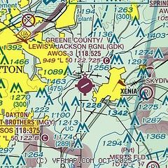
| Sectional chart |
|---|
|
| Airport distance calculator |
|---|
|
|
| Sunrise and sunset |
|---|
|
Times for 13-May-2026
| | Local
(UTC-4) | | Zulu
(UTC) |
|---|
| Morning civil twilight | | 05:54 | | 09:54 |
| Sunrise | | 06:24 | | 10:24 |
| Sunset | | 20:40 | | 00:40 |
| Evening civil twilight | | 21:11 | | 01:11 |
|
| Current date and time |
|---|
| Zulu (UTC) | 13-May-2026 07:34:47 |
|---|
| Local (UTC-4) | 13-May-2026 03:34:47 |
|---|
|
| METAR |
|---|
KFFO
8nm N | 130655Z 25006KT 10SM -RA SCT060 OVC085 16/11 A2989 RMK AO2A SLP121 P0001 T01640113
|
KMGY
12nm SW | 130653Z AUTO 24007KT 10SM -RA OVC080 17/09 A2991 RMK AO2 RAB19 SLP122 P0000 T01720094
|
KDAY
16nm NW | 130656Z 00000KT 10SM BKN060 OVC080 14/12 A2991 RMK AO2 RAE55 SLP124 P0003 T01440117
|
KILN
18nm SE | 130654Z AUTO 24010G19KT 10SM SCT080 17/07 A2991 RMK AO2 SLP126 T01720067
|
KI68
18nm SW | 130715Z AUTO 24006KT 9SM -RA FEW047 OVC065 16/13 A2990 RMK AO2
|
|
| TAF |
|---|
KFFO
8nm N | 130300Z 1303/1409 21009KT 9999 FEW060 BKN150 BKN200 QNH2989INS BECMG 1304/1306 22012KT 9000 -SHRA BKN050 OVC080 520103 QNH2982INS TEMPO 1306/1311 23015G25KT 3200 -SHRA BR BKN030 OVC050 WND 190V340 BECMG 1309/1311 24012KT 9999 VCSH BKN025 BKN050 520103 QNH2982INS TEMPO 1311/1315 24015G25KT BKN015 OVC030 WND 180V300 BECMG 1313/1315 29012G18KT 9999 NSW BKN040 QNH2983INS TEMPO 1315/1402 30015G25KT WND 210V330 BECMG 1401/1403 32009KT 9999 SCT040 510102 QNH2992INS TX20/1303Z TN10/1403Z
|
KDAY
16nm NW | 130531Z 1306/1406 22013KT P6SM -SHRA SCT050 OVC120 FM130900 23014KT P6SM SCT050 FM131400 30016G25KT P6SM BKN035 TEMPO 1315/1318 BKN030 FM131800 31020G30KT P6SM BKN035 FM140100 32015G25KT P6SM SCT035
|
KILN
18nm SE | 130531Z 1306/1406 21011KT P6SM OVC120 FM130700 22012KT P6SM -SHRA SCT060 OVC100 FM131000 23012KT P6SM SCT050 FM131400 29017G27KT P6SM BKN040 FM131900 32020G30KT P6SM BKN035 FM140100 32015G25KT P6SM SCT040
|
|
| NOTAMs |
|---|
NOTAMs are issued by the DoD/FAA and will open in a separate window not controlled by AirNav.
|
|


